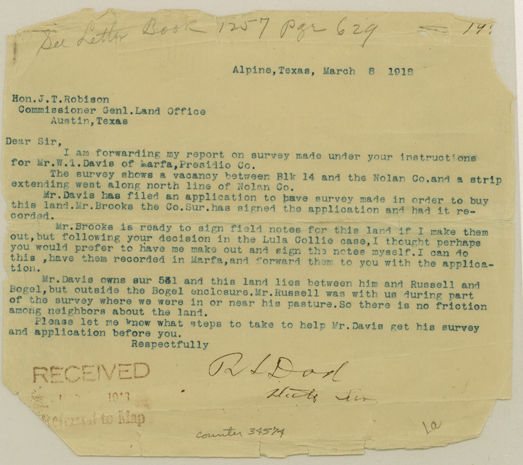
Presidio County Sketch File 47
[Field notes of survey 532, Block 249, and Block 14 G.H.&S.A.]
-
Map/Doc
34574
-
Collection
General Map Collection
-
Object Dates
3/8/1918 (Creation Date)
3/11/1918 (File Date)
3/8/1918 (Correspondence Date)
2/1918 (Survey Date)
3/6/1918 (Creation Date)
-
People and Organizations
R.S. Dod (Surveyor/Engineer)
Henry W. Brooks (Surveyor/Engineer)
Rial Barnet (Chainman/Field Personnel)
W.B. Russell (Chainman/Field Personnel)
S.A. Thompson (Surveyor/Engineer)
Tom Seay (Surveyor/Engineer)
J. Hoban (Surveyor/Engineer)
-
Counties
Presidio
-
Subjects
Surveying Sketch File
-
Height x Width
7.2 x 8.1 inches
18.3 x 20.6 cm
-
Medium
paper, manuscript
-
Comments
See Presidio County Sketch File 48 (34582) for sketch.
-
Features
Lone Peak
La Mota Mountain
Sierra Rica
Torneros Creek
Needle Peak
Conical Peak
Sierra Rica Mountains
Cuerva Larga Creek
Old Smugglers Trail
[Road from] Presidio to Lajitas
Canyon de Lyeba
Related maps
Presidio County Sketch File 48

Print $6.00
- Digital $50.00
Presidio County Sketch File 48
1918
Size 15.1 x 11.0 inches
Map/Doc 34582
Part of: General Map Collection
Schleicher County Sketch File 32

Print $22.00
- Digital $50.00
Schleicher County Sketch File 32
1941
Size 9.1 x 13.3 inches
Map/Doc 36532
Ft. W. & R. G. Ry. Right of Way Map, Chapin to Bluffdale, Hood County, Texas

Print $40.00
- Digital $50.00
Ft. W. & R. G. Ry. Right of Way Map, Chapin to Bluffdale, Hood County, Texas
1918
Size 36.5 x 50.5 inches
Map/Doc 64645
[Sketch for Mineral Application 27669 - Trinity River, Frank R. Graves]
![2861, [Sketch for Mineral Application 27669 - Trinity River, Frank R. Graves], General Map Collection](https://historictexasmaps.com/wmedia_w700/maps/2861-1.tif.jpg)
Print $40.00
- Digital $50.00
[Sketch for Mineral Application 27669 - Trinity River, Frank R. Graves]
1934
Size 27.4 x 61.6 inches
Map/Doc 2861
Van Zandt County Sketch File 37

Print $4.00
- Digital $50.00
Van Zandt County Sketch File 37
1861
Size 12.2 x 7.8 inches
Map/Doc 39480
Washington County

Print $20.00
- Digital $50.00
Washington County
1920
Size 32.5 x 47.2 inches
Map/Doc 16918
Map of the State of Texas [East Part]
![81920, Map of the State of Texas [East Part], General Map Collection](https://historictexasmaps.com/wmedia_w700/maps/81920.tif.jpg)
Print $40.00
- Digital $50.00
Map of the State of Texas [East Part]
1938
Size 67.8 x 37.3 inches
Map/Doc 81920
Jeff Davis County Sketch File 15

Print $20.00
- Digital $50.00
Jeff Davis County Sketch File 15
1883
Size 28.5 x 18.9 inches
Map/Doc 11859
Jeff Davis County Working Sketch 31

Print $20.00
- Digital $50.00
Jeff Davis County Working Sketch 31
1969
Size 41.6 x 43.3 inches
Map/Doc 66526
Val Verde County Working Sketch 34

Print $20.00
- Digital $50.00
Val Verde County Working Sketch 34
1940
Size 33.7 x 27.9 inches
Map/Doc 72169
Edwards County Working Sketch 82

Print $20.00
- Digital $50.00
Edwards County Working Sketch 82
1964
Size 31.0 x 35.1 inches
Map/Doc 68958
Map of Marion County

Print $20.00
- Digital $50.00
Map of Marion County
1920
Size 29.6 x 42.7 inches
Map/Doc 66917
Hardin County Working Sketch 44

Print $40.00
- Digital $50.00
Hardin County Working Sketch 44
1954
Size 53.1 x 39.5 inches
Map/Doc 69764
You may also like
Webb County Rolled Sketch EF4

Print $20.00
- Digital $50.00
Webb County Rolled Sketch EF4
1929
Size 33.2 x 24.4 inches
Map/Doc 8226
Coke County Rolled Sketch 8

Print $20.00
- Digital $50.00
Coke County Rolled Sketch 8
Size 26.5 x 34.8 inches
Map/Doc 5507
Falls County Sketch File 29

Print $40.00
- Digital $50.00
Falls County Sketch File 29
Size 19.9 x 23.5 inches
Map/Doc 75994

Hunt County Rolled Sketch 4

Print $209.00
- Digital $50.00
Hunt County Rolled Sketch 4
1959
Size 10.4 x 15.2 inches
Map/Doc 45992
Hood County Working Sketch 18

Print $40.00
- Digital $50.00
Hood County Working Sketch 18
1987
Size 38.8 x 59.0 inches
Map/Doc 66212
Flight Mission No. DCL-5C, Frame 48, Kenedy County

Print $20.00
- Digital $50.00
Flight Mission No. DCL-5C, Frame 48, Kenedy County
1943
Size 18.6 x 22.2 inches
Map/Doc 85844
Flight Mission No. DAG-22K, Frame 81, Matagorda County

Print $20.00
- Digital $50.00
Flight Mission No. DAG-22K, Frame 81, Matagorda County
1953
Size 18.6 x 22.4 inches
Map/Doc 86465
Rusk County Sketch File Z

Print $6.00
Rusk County Sketch File Z
1850
Size 15.8 x 9.0 inches
Map/Doc 35539
Parker County Sketch File 9a

Print $4.00
- Digital $50.00
Parker County Sketch File 9a
1859
Size 9.0 x 7.7 inches
Map/Doc 33540
Aransas County Rolled Sketch 16

Digital $50.00
Aransas County Rolled Sketch 16
Size 49.9 x 97.2 inches
Map/Doc 9004
Disputed Territory Between Mexico and the United States

Disputed Territory Between Mexico and the United States
2024
Size 10.7 x 7.9 inches
Map/Doc 97251