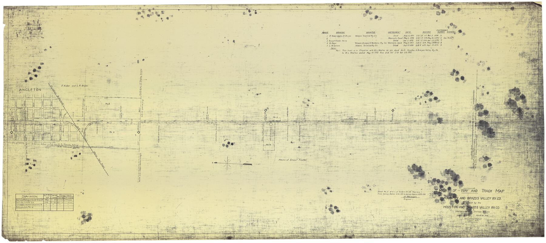
Right-of-Way and Track Map, Houston and Brazos Valley Ry. Co. operated by the Houston and Brazos Valley Ry. Co.
Station 218+08 to Station 426+00
Z-2-185
-
Map/Doc
64607
-
Collection
General Map Collection
-
Object Dates
3/30/1918 (Creation Date)
7/23/1929 (Revision Date)
12/23/1929 (Revision Date)
-
People and Organizations
A. Munson (Surveyor/Engineer)
J. H. Cain (Draftsman)
J. T. Alley (Draftsman)
-
Counties
Brazoria
-
Subjects
Railroads
-
Height x Width
24.9 x 56.5 inches
63.3 x 143.5 cm
-
Medium
blueprint/diazo
-
Scale
1" = 400 feet
-
Comments
See counter nos. 64602 through 64611 and 66713 for other sheets.
-
Features
H&BV
SLB&M
Angleton
Part of: General Map Collection
Hutchinson County Rolled Sketch 8

Print $20.00
- Digital $50.00
Hutchinson County Rolled Sketch 8
Size 32.0 x 29.1 inches
Map/Doc 6279
Presidio County Rolled Sketch 73

Print $40.00
- Digital $50.00
Presidio County Rolled Sketch 73
Size 58.8 x 29.5 inches
Map/Doc 8351
Dallam County

Print $40.00
- Digital $50.00
Dallam County
1926
Size 40.1 x 48.6 inches
Map/Doc 73125
Wharton County Working Sketch 13

Print $20.00
- Digital $50.00
Wharton County Working Sketch 13
1968
Size 38.5 x 36.3 inches
Map/Doc 72477
Montague County Rolled Sketch R

Print $20.00
- Digital $50.00
Montague County Rolled Sketch R
Size 44.3 x 29.8 inches
Map/Doc 6794
Webb County Rolled Sketch 58

Print $40.00
- Digital $50.00
Webb County Rolled Sketch 58
1946
Size 36.7 x 53.4 inches
Map/Doc 10127
[Cotton Belt, St. Louis Southwestern Railway of Texas, Alignment through Smith County]
![64382, [Cotton Belt, St. Louis Southwestern Railway of Texas, Alignment through Smith County], General Map Collection](https://historictexasmaps.com/wmedia_w700/maps/64382.tif.jpg)
Print $20.00
- Digital $50.00
[Cotton Belt, St. Louis Southwestern Railway of Texas, Alignment through Smith County]
1903
Size 21.8 x 29.1 inches
Map/Doc 64382
Current Miscellaneous File 69

Print $10.00
- Digital $50.00
Current Miscellaneous File 69
1916
Size 11.2 x 8.8 inches
Map/Doc 74145
Chambers County Sketch File 16

Print $4.00
- Digital $50.00
Chambers County Sketch File 16
Size 7.9 x 12.7 inches
Map/Doc 17566
Childress County Rolled Sketch 16B

Print $40.00
- Digital $50.00
Childress County Rolled Sketch 16B
Size 26.3 x 78.1 inches
Map/Doc 8600
Angelina County Sketch File 21c

Print $4.00
- Digital $50.00
Angelina County Sketch File 21c
1889
Size 14.1 x 8.7 inches
Map/Doc 13047
Rio Grande, Hargill Sheet

Print $20.00
- Digital $50.00
Rio Grande, Hargill Sheet
1937
Size 37.3 x 37.8 inches
Map/Doc 65109
You may also like
[Sketch for Mineral Application 33721 - 33725 Incl. - Padre and Mustang Island]
![2873, [Sketch for Mineral Application 33721 - 33725 Incl. - Padre and Mustang Island], General Map Collection](https://historictexasmaps.com/wmedia_w700/maps/2873.tif.jpg)
Print $20.00
- Digital $50.00
[Sketch for Mineral Application 33721 - 33725 Incl. - Padre and Mustang Island]
1942
Size 26.6 x 22.7 inches
Map/Doc 2873
Runnels County Sketch File 41

Print $20.00
Runnels County Sketch File 41
1892
Size 22.8 x 25.7 inches
Map/Doc 12271
Burnet County Sketch File 46

Print $4.00
- Digital $50.00
Burnet County Sketch File 46
1873
Size 12.8 x 8.5 inches
Map/Doc 16773
[Right of Way & Track Map, The Texas & Pacific Ry. Co. Main Line]
![64673, [Right of Way & Track Map, The Texas & Pacific Ry. Co. Main Line], General Map Collection](https://historictexasmaps.com/wmedia_w700/maps/64673.tif.jpg)
Print $20.00
- Digital $50.00
[Right of Way & Track Map, The Texas & Pacific Ry. Co. Main Line]
Size 11.2 x 18.6 inches
Map/Doc 64673
Stonewall County Sketch File 12 and 12a

Print $30.00
- Digital $50.00
Stonewall County Sketch File 12 and 12a
1900
Size 9.2 x 9.0 inches
Map/Doc 37240
Henderson County Working Sketch 8

Print $20.00
- Digital $50.00
Henderson County Working Sketch 8
1922
Size 15.9 x 16.1 inches
Map/Doc 66141
Travis County Boundary File 24

Print $4.00
- Digital $50.00
Travis County Boundary File 24
Size 8.3 x 7.2 inches
Map/Doc 59457
Brewster County Sketch File 20

Print $40.00
- Digital $50.00
Brewster County Sketch File 20
1946
Size 19.1 x 15.2 inches
Map/Doc 10979
Robertson County Sketch File 6

Print $4.00
Robertson County Sketch File 6
1870
Size 8.9 x 7.6 inches
Map/Doc 35362

General Highway Map, Austin County, Texas

Print $20.00
General Highway Map, Austin County, Texas
1961
Size 18.1 x 25.1 inches
Map/Doc 79357
Map of the United States and Texas Boundary Line and adjacent territory determined & surveyed in 1857-8-9-60 by J.H. Clark, U.S. Commissioner, &ca. &ca. under the direction of the Departement [sic] of the Interior
![94063, Map of the United States and Texas Boundary Line and adjacent territory determined & surveyed in 1857-8-9-60 by J.H. Clark, U.S. Commissioner, &ca. &ca. under the direction of the Departement [sic] of the Interior, General Map Collection](https://historictexasmaps.com/wmedia_w700/maps/94063.tif.jpg)
Print $20.00
- Digital $50.00
Map of the United States and Texas Boundary Line and adjacent territory determined & surveyed in 1857-8-9-60 by J.H. Clark, U.S. Commissioner, &ca. &ca. under the direction of the Departement [sic] of the Interior
1902
Size 27.9 x 41.8 inches
Map/Doc 94063