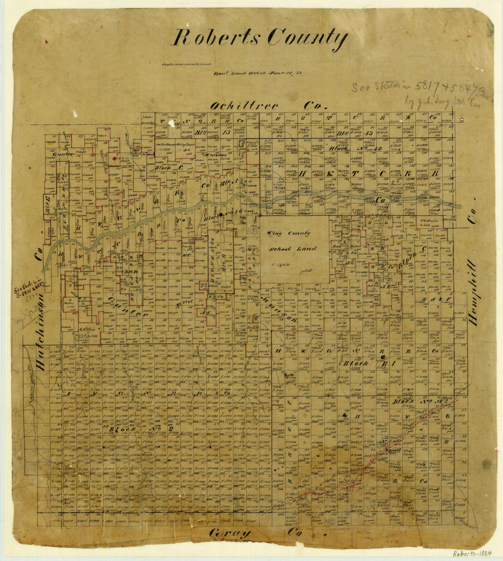
Roberts County
-
Map/Doc
3992
-
Collection
General Map Collection
-
Object Dates
1884/6/27 (Creation Date)
-
People and Organizations
Texas General Land Office (Publisher)
-
Counties
Roberts
-
Subjects
County
-
Height x Width
20.3 x 18.2 inches
51.6 x 46.2 cm
-
Features
Willow Creek
Walker Creek
Martins Creek
Timber Creek
Palaholie Creek
Dudley Creek
St. Clar [sic] Creek
Red Deer Creek
Walnut Creek
White Deer Creek
SKR
Miami
Brown's Creek
Concord
Part of: General Map Collection
Martin County Working Sketch 17

Print $20.00
- Digital $50.00
Martin County Working Sketch 17
1981
Size 32.4 x 41.4 inches
Map/Doc 70835
Orange County Sketch File 16

Print $20.00
- Digital $50.00
Orange County Sketch File 16
Size 18.1 x 32.8 inches
Map/Doc 12119
Soil Map, Texas, Titus County Sheet

Print $20.00
- Digital $50.00
Soil Map, Texas, Titus County Sheet
1909
Size 30.5 x 22.4 inches
Map/Doc 3080
Henderson County Working Sketch 39

Print $20.00
- Digital $50.00
Henderson County Working Sketch 39
1982
Size 24.3 x 19.0 inches
Map/Doc 66172
Henderson County Sketch File 13

Print $4.00
- Digital $50.00
Henderson County Sketch File 13
1876
Size 8.2 x 12.8 inches
Map/Doc 26353
Outer Continental Shelf Leasing Maps (Louisiana Offshore Operations)

Print $20.00
- Digital $50.00
Outer Continental Shelf Leasing Maps (Louisiana Offshore Operations)
1955
Size 16.2 x 13.0 inches
Map/Doc 76084
Rio Grande Rectification Project, El Paso and Juarez Valley

Print $20.00
- Digital $50.00
Rio Grande Rectification Project, El Paso and Juarez Valley
1935
Size 10.9 x 29.6 inches
Map/Doc 60868
North Part Brewster Co.

Print $40.00
- Digital $50.00
North Part Brewster Co.
1914
Size 40.4 x 49.3 inches
Map/Doc 66732
[Sketch for Mineral Application 16787 - Pecos River Bed, A. T. Freet]
![65632, [Sketch for Mineral Application 16787 - Pecos River Bed, A. T. Freet], General Map Collection](https://historictexasmaps.com/wmedia_w700/maps/65632-1.tif.jpg)
Print $40.00
- Digital $50.00
[Sketch for Mineral Application 16787 - Pecos River Bed, A. T. Freet]
Size 70.8 x 18.9 inches
Map/Doc 65632
Packery Channel

Print $20.00
- Digital $50.00
Packery Channel
1975
Size 26.2 x 21.5 inches
Map/Doc 2991
Hemphill County Working Sketch 14

Print $20.00
- Digital $50.00
Hemphill County Working Sketch 14
1969
Size 34.0 x 44.8 inches
Map/Doc 66109
Milam County Rolled Sketch 2

Print $20.00
- Digital $50.00
Milam County Rolled Sketch 2
1954
Size 21.9 x 24.8 inches
Map/Doc 6774
You may also like
Matagorda Light to Aransas Pass

Print $20.00
- Digital $50.00
Matagorda Light to Aransas Pass
1961
Size 35.9 x 44.7 inches
Map/Doc 73396
San Patricio County Working Sketch 23

Print $20.00
- Digital $50.00
San Patricio County Working Sketch 23
1984
Size 43.5 x 43.8 inches
Map/Doc 63785
Nolan County Boundary File 2

Print $52.00
- Digital $50.00
Nolan County Boundary File 2
Size 8.7 x 8.1 inches
Map/Doc 57649
Galveston County NRC Article 33.136 Location Key Sheet

Print $20.00
- Digital $50.00
Galveston County NRC Article 33.136 Location Key Sheet
1994
Size 27.0 x 21.8 inches
Map/Doc 77017
Live Oak County Boundary File 60d

Print $4.00
- Digital $50.00
Live Oak County Boundary File 60d
Size 14.2 x 8.8 inches
Map/Doc 56423
Cass County Working Sketch 7

Print $20.00
- Digital $50.00
Cass County Working Sketch 7
1937
Size 21.9 x 28.9 inches
Map/Doc 67910
Armstrong County Sketch File 9

Print $12.00
- Digital $50.00
Armstrong County Sketch File 9
1904
Size 11.6 x 9.1 inches
Map/Doc 41460
Map of the Territory of the United States from the Mississippi to the Pacific Ocean ordered by the Hon. Jeff'n Davis, Secretary of War to accompany the reports of the explorations for a railroad route

Print $40.00
- Digital $50.00
Map of the Territory of the United States from the Mississippi to the Pacific Ocean ordered by the Hon. Jeff'n Davis, Secretary of War to accompany the reports of the explorations for a railroad route
Size 48.6 x 50.7 inches
Map/Doc 94276
Galveston County Sketch File 5

Print $4.00
- Digital $50.00
Galveston County Sketch File 5
1848
Size 8.6 x 9.0 inches
Map/Doc 23358

Controlled Mosaic by Jack Amman Photogrammetric Engineers, Inc - Sheet 44

Print $20.00
- Digital $50.00
Controlled Mosaic by Jack Amman Photogrammetric Engineers, Inc - Sheet 44
1954
Size 20.0 x 24.0 inches
Map/Doc 83503
Flight Mission No. BRA-16M, Frame 132, Jefferson County

Print $20.00
- Digital $50.00
Flight Mission No. BRA-16M, Frame 132, Jefferson County
1953
Size 18.6 x 22.3 inches
Map/Doc 85742