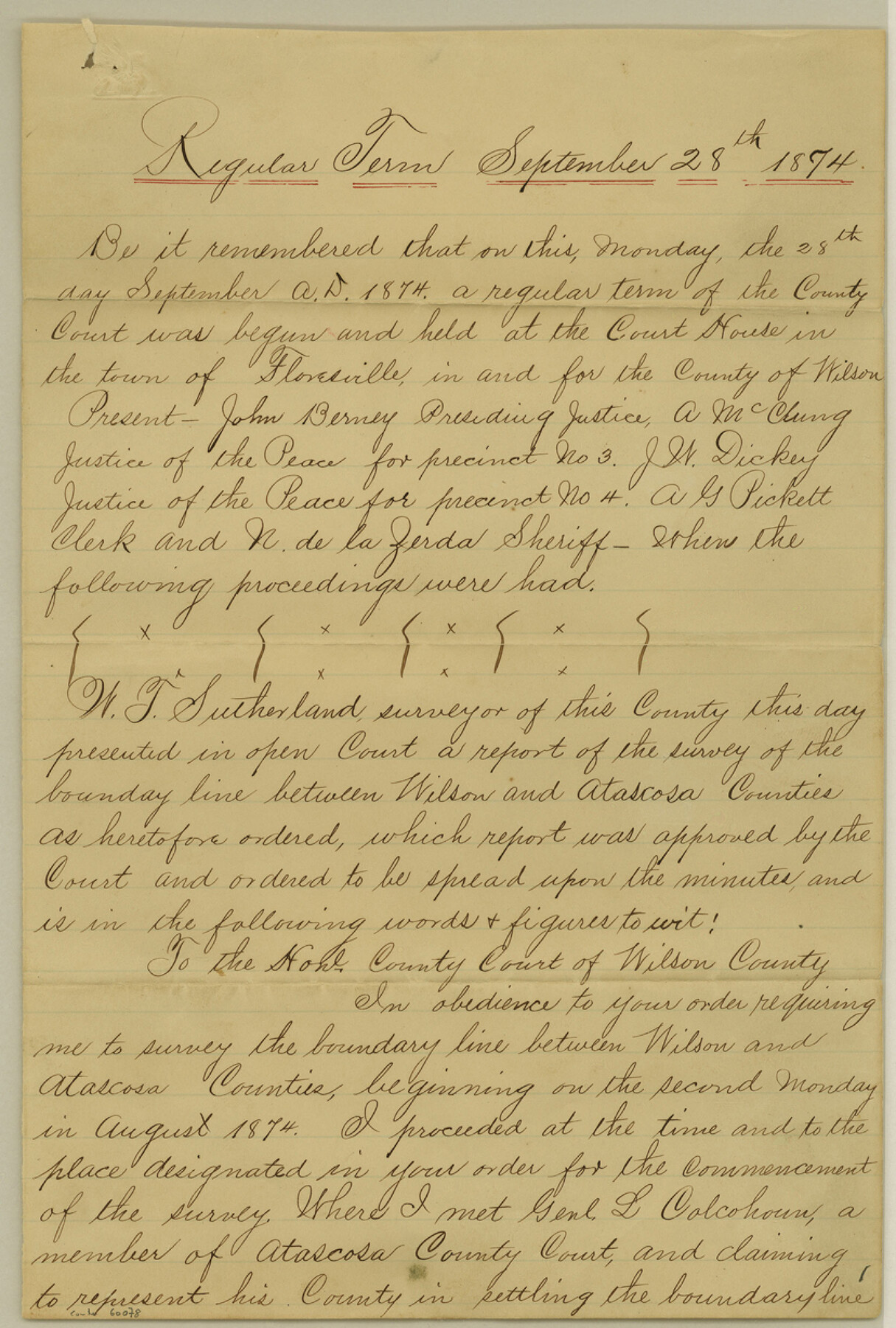
Wilson County Boundary File 2
County Line between Atascosa and Wilson
-
Map/Doc
60078
-
Collection
General Map Collection
-
Counties
Wilson
-
Subjects
County Boundaries
-
Height x Width
12.3 x 8.3 inches
31.2 x 21.1 cm
Part of: General Map Collection
Blanco County Working Sketch 10

Print $20.00
- Digital $50.00
Blanco County Working Sketch 10
1938
Size 28.3 x 25.8 inches
Map/Doc 67370
San Augustine Co.

Print $40.00
- Digital $50.00
San Augustine Co.
1949
Size 48.9 x 32.2 inches
Map/Doc 95632
Flight Mission No. DCL-7C, Frame 124, Kenedy County

Print $20.00
- Digital $50.00
Flight Mission No. DCL-7C, Frame 124, Kenedy County
1943
Size 18.6 x 22.2 inches
Map/Doc 86089
Montgomery County

Print $20.00
- Digital $50.00
Montgomery County
1895
Size 21.6 x 24.8 inches
Map/Doc 3897
Jasper County Working Sketch 12

Print $40.00
- Digital $50.00
Jasper County Working Sketch 12
1920
Size 50.6 x 38.3 inches
Map/Doc 66474
Outer Continental Shelf Leasing Maps (Louisiana Offshore Operations)

Print $20.00
- Digital $50.00
Outer Continental Shelf Leasing Maps (Louisiana Offshore Operations)
1959
Size 18.1 x 14.3 inches
Map/Doc 76110
Calhoun County Rolled Sketch 33

Print $73.00
- Digital $50.00
Calhoun County Rolled Sketch 33
1979
Size 10.0 x 15.2 inches
Map/Doc 43687
Flight Mission No. DAG-14K, Frame 43, Matagorda County

Print $20.00
- Digital $50.00
Flight Mission No. DAG-14K, Frame 43, Matagorda County
1952
Size 18.4 x 22.4 inches
Map/Doc 86301
Lamb County Boundary File 2

Print $102.00
- Digital $50.00
Lamb County Boundary File 2
Size 15.4 x 9.1 inches
Map/Doc 56057
Coryell County Working Sketch 24

Print $20.00
- Digital $50.00
Coryell County Working Sketch 24
1979
Size 35.5 x 34.5 inches
Map/Doc 68231
Hill County Sketch File 3

Print $2.00
- Digital $50.00
Hill County Sketch File 3
Size 8.3 x 10.4 inches
Map/Doc 26463
Foard County Sketch File 6

Print $4.00
- Digital $50.00
Foard County Sketch File 6
1875
Size 10.2 x 8.4 inches
Map/Doc 22808
You may also like
[H. & T. C. Block 47, H. & G. N. Block E]
![91259, [H. & T. C. Block 47, H. & G. N. Block E], Twichell Survey Records](https://historictexasmaps.com/wmedia_w700/maps/91259-1.tif.jpg)
Print $20.00
- Digital $50.00
[H. & T. C. Block 47, H. & G. N. Block E]
1874
Size 22.1 x 12.9 inches
Map/Doc 91259
Sutton County Sketch File JT

Print $12.00
- Digital $50.00
Sutton County Sketch File JT
Size 14.4 x 8.6 inches
Map/Doc 37453
Gray County Sketch File 5

Print $16.00
- Digital $50.00
Gray County Sketch File 5
1882
Size 12.8 x 8.3 inches
Map/Doc 24418
Kimble County Rolled Sketch 42

Print $20.00
- Digital $50.00
Kimble County Rolled Sketch 42
1995
Size 37.7 x 47.8 inches
Map/Doc 9341
[Sketch of area just south of Levi Pruitt survey]
![91854, [Sketch of area just south of Levi Pruitt survey], Twichell Survey Records](https://historictexasmaps.com/wmedia_w700/maps/91854-1.tif.jpg)
Print $20.00
- Digital $50.00
[Sketch of area just south of Levi Pruitt survey]
Size 24.9 x 18.6 inches
Map/Doc 91854
Flight Mission No. BQR-9K, Frame 7, Brazoria County

Print $20.00
- Digital $50.00
Flight Mission No. BQR-9K, Frame 7, Brazoria County
1952
Size 18.7 x 22.5 inches
Map/Doc 84036
Map of the Fort Worth & Denver City Railway

Print $40.00
- Digital $50.00
Map of the Fort Worth & Denver City Railway
1887
Size 19.9 x 57.9 inches
Map/Doc 64477
Irion County Rolled Sketch 10

Print $20.00
- Digital $50.00
Irion County Rolled Sketch 10
1942
Size 29.8 x 29.1 inches
Map/Doc 6322
Galveston County Sketch File 48

Print $44.00
- Digital $50.00
Galveston County Sketch File 48
1976
Size 14.3 x 8.8 inches
Map/Doc 23460
Wilbarger County Sketch File 22

Print $4.00
- Digital $50.00
Wilbarger County Sketch File 22
1889
Size 9.7 x 6.2 inches
Map/Doc 40221
Hall County Sketch File 28

Print $20.00
- Digital $50.00
Hall County Sketch File 28
1913
Size 18.0 x 21.5 inches
Map/Doc 11611
[Townships 1 & 2, Blocks 56, 57]
![92927, [Townships 1 & 2, Blocks 56, 57], Twichell Survey Records](https://historictexasmaps.com/wmedia_w700/maps/92927-1.tif.jpg)
Print $20.00
- Digital $50.00
[Townships 1 & 2, Blocks 56, 57]
Size 19.7 x 22.8 inches
Map/Doc 92927