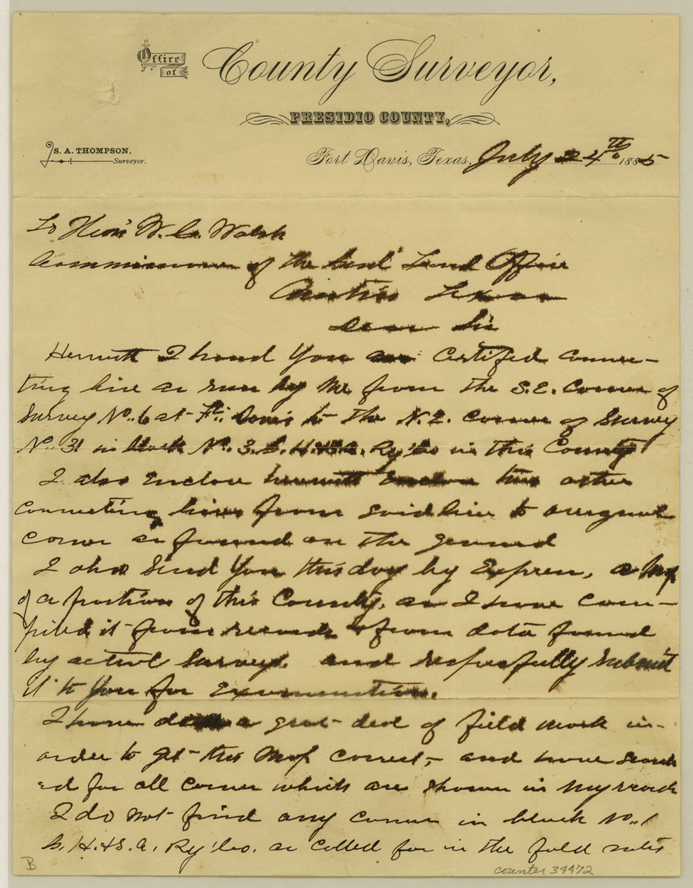
Presidio County Sketch File 32
[Letter regarding connection of southeast corner of survey 6 to Ft. Davis]
-
Map/Doc
34472
-
Collection
General Map Collection
-
Object Dates
7/24/1885 (Creation Date)
8/12/1911 (File Date)
7/24/1885 (Correspondence Date)
-
People and Organizations
S.A. Thompson (Surveyor/Engineer)
-
Counties
Presidio
-
Subjects
Surveying Sketch File
-
Height x Width
11.2 x 8.7 inches
28.4 x 22.1 cm
-
Medium
paper, manuscript
-
Features
Oak Creek
Ben Homus Creek
Cedar Creek
Part of: General Map Collection
El Paso County Working Sketch 44

Print $20.00
- Digital $50.00
El Paso County Working Sketch 44
1992
Size 25.6 x 25.4 inches
Map/Doc 69066
Plat of Resurvey of Sections 13, 24, 25 and 26, T. 5S., R. 12W., of the Indian Meridian, Oklahoma

Print $4.00
- Digital $50.00
Plat of Resurvey of Sections 13, 24, 25 and 26, T. 5S., R. 12W., of the Indian Meridian, Oklahoma
1917
Size 18.3 x 24.1 inches
Map/Doc 75158
Flight Mission No. CLL-4N, Frame 37, Willacy County

Print $20.00
- Digital $50.00
Flight Mission No. CLL-4N, Frame 37, Willacy County
1954
Size 18.4 x 22.1 inches
Map/Doc 87110
Hamilton County Sketch File 15

Print $2.00
- Digital $50.00
Hamilton County Sketch File 15
1882
Size 8.0 x 11.8 inches
Map/Doc 24941
Martha's Vineyard to Block Island Including Western Approach to Cape Cod Canal

Print $20.00
- Digital $50.00
Martha's Vineyard to Block Island Including Western Approach to Cape Cod Canal
1963
Size 51.1 x 36.9 inches
Map/Doc 73555
Matagorda County Sketch File 36

Print $6.00
- Digital $50.00
Matagorda County Sketch File 36
Size 12.1 x 8.3 inches
Map/Doc 30827
Edwards County Sketch File 23

Print $8.00
- Digital $50.00
Edwards County Sketch File 23
1881
Size 14.4 x 9.0 inches
Map/Doc 21747
Edwards County Sketch File 51

Print $32.00
- Digital $50.00
Edwards County Sketch File 51
1965
Size 11.6 x 9.0 inches
Map/Doc 21800
Red River County Working Sketch 43

Print $40.00
- Digital $50.00
Red River County Working Sketch 43
1968
Size 72.5 x 36.8 inches
Map/Doc 72026
Starr County Sketch File 13

Print $20.00
- Digital $50.00
Starr County Sketch File 13
1886
Size 12.4 x 19.5 inches
Map/Doc 12329
Pecos County Rolled Sketch 165

Print $20.00
- Digital $50.00
Pecos County Rolled Sketch 165
1966
Size 23.4 x 19.6 inches
Map/Doc 7290
Galveston County NRC Article 33.136 Sketch 59

Print $24.00
- Digital $50.00
Galveston County NRC Article 33.136 Sketch 59
2008
Size 11.5 x 17.0 inches
Map/Doc 94606
You may also like
General Highway Map, Gray County, Texas

Print $20.00
General Highway Map, Gray County, Texas
1940
Size 25.0 x 18.4 inches
Map/Doc 79103
St. Louis, Brownsville & Mexico Railway Location Map from Mile 80 to Mile 100

Print $40.00
- Digital $50.00
St. Louis, Brownsville & Mexico Railway Location Map from Mile 80 to Mile 100
1905
Size 19.4 x 60.9 inches
Map/Doc 64165
Aransas County Working Sketch 19

Print $20.00
- Digital $50.00
Aransas County Working Sketch 19
1978
Size 25.1 x 31.1 inches
Map/Doc 67186
La Salle County Rolled Sketch 10

Print $40.00
- Digital $50.00
La Salle County Rolled Sketch 10
1945
Size 48.1 x 33.5 inches
Map/Doc 6573
![91955, [PSL Block B19], Twichell Survey Records](https://historictexasmaps.com/wmedia_w700/maps/91955-1.tif.jpg)
Flight Mission No. CLL-1N, Frame 196, Willacy County

Print $20.00
- Digital $50.00
Flight Mission No. CLL-1N, Frame 196, Willacy County
1954
Size 18.5 x 22.2 inches
Map/Doc 87066
Maverick County Rolled Sketch 13

Print $20.00
- Digital $50.00
Maverick County Rolled Sketch 13
1848
Size 34.4 x 26.5 inches
Map/Doc 6706
Kaufman County Working Sketch 1

Print $20.00
- Digital $50.00
Kaufman County Working Sketch 1
1921
Size 21.4 x 47.6 inches
Map/Doc 66664
Maps of Gulf Intracoastal Waterway, Texas - Sabine River to the Rio Grande and connecting waterways including ship channels

Print $20.00
- Digital $50.00
Maps of Gulf Intracoastal Waterway, Texas - Sabine River to the Rio Grande and connecting waterways including ship channels
1966
Size 14.6 x 21.0 inches
Map/Doc 61988
Culberson County Working Sketch 71

Print $40.00
- Digital $50.00
Culberson County Working Sketch 71
1975
Size 48.4 x 32.9 inches
Map/Doc 68525
Flight Mission No. CUG-2P, Frame 88, Kleberg County

Print $20.00
- Digital $50.00
Flight Mission No. CUG-2P, Frame 88, Kleberg County
1956
Size 18.5 x 22.2 inches
Map/Doc 86220
Atascosa County Sketch File 22

Print $6.00
- Digital $50.00
Atascosa County Sketch File 22
Size 14.2 x 8.6 inches
Map/Doc 13789