Pecos County Rolled Sketch 165
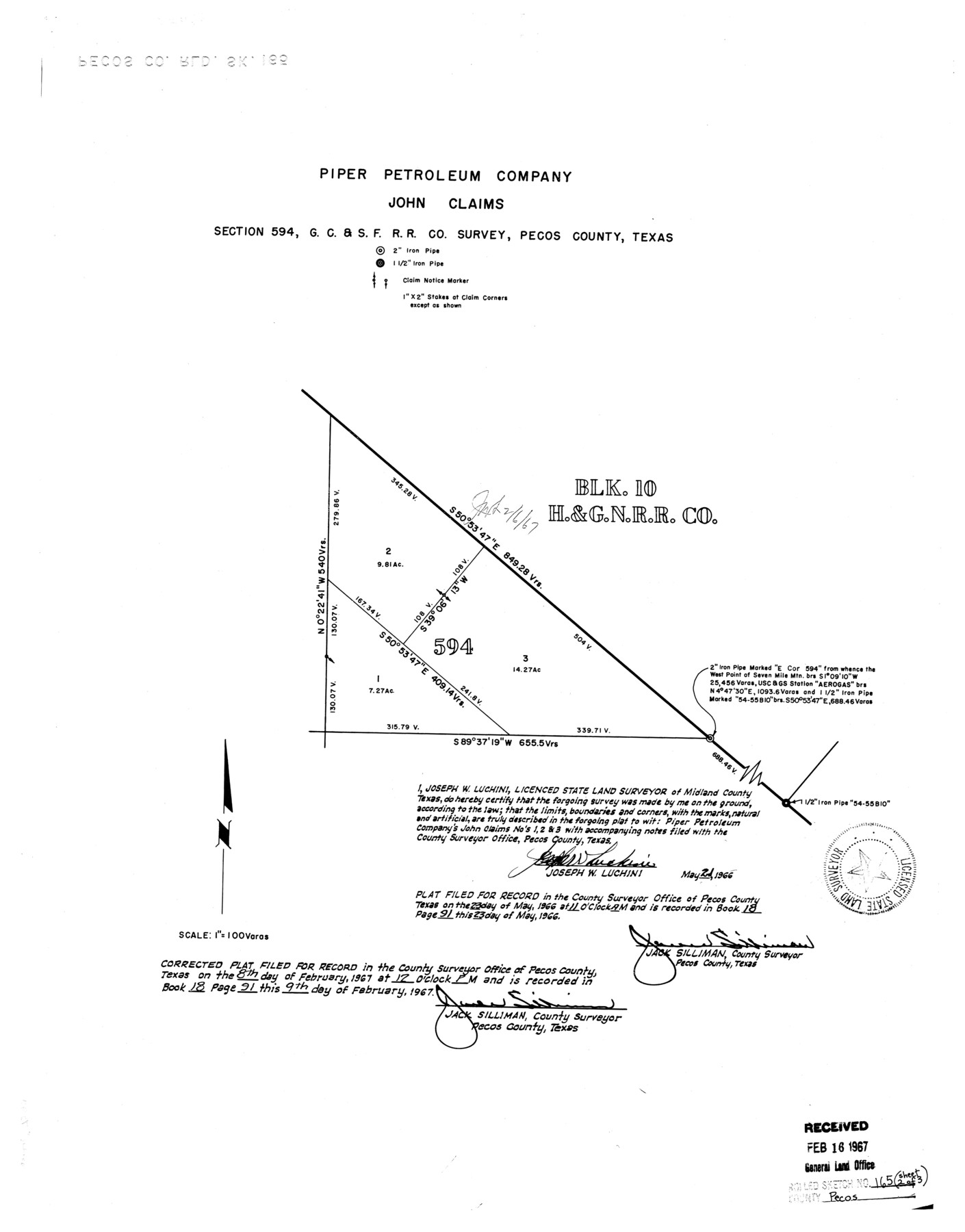
Piper Petroleum Company, John Claims, section 594, G. C. & S. F. R.R. Co. survey, Pecos County, Texas
-
Map/Doc
7290
-
Collection
General Map Collection
-
Object Dates
5/21/1966 (Creation Date)
2/16/1967 (File Date)
-
People and Organizations
Joseph W. Luchini (Surveyor/Engineer)
-
Counties
Pecos
-
Subjects
Surveying Rolled Sketch
-
Height x Width
23.4 x 19.6 inches
59.4 x 49.8 cm
-
Scale
1" = 100 varas
-
Comments
Sheet 3 of 3.
Part of: General Map Collection
Nueces County Sketch File 59

Print $23.00
- Digital $50.00
Nueces County Sketch File 59
1989
Size 11.2 x 8.6 inches
Map/Doc 32951
Presidio County Sketch File 1

Print $40.00
- Digital $50.00
Presidio County Sketch File 1
1857
Size 24.7 x 16.0 inches
Map/Doc 11703
Liberty County Rolled Sketch J

Print $20.00
- Digital $50.00
Liberty County Rolled Sketch J
1943
Size 29.1 x 38.0 inches
Map/Doc 10646
Brazoria County Working Sketch 42

Print $20.00
- Digital $50.00
Brazoria County Working Sketch 42
1984
Size 43.5 x 47.1 inches
Map/Doc 67527
Roberts County Working Sketch 34

Print $20.00
- Digital $50.00
Roberts County Working Sketch 34
1978
Size 26.6 x 22.5 inches
Map/Doc 63560
McMullen County Sketch File 44

Print $6.00
- Digital $50.00
McMullen County Sketch File 44
1942
Size 14.2 x 8.8 inches
Map/Doc 31426
Cameron County Rolled Sketch 19

Print $20.00
- Digital $50.00
Cameron County Rolled Sketch 19
Size 25.8 x 23.6 inches
Map/Doc 5465
Maverick County Working Sketch 6

Print $40.00
- Digital $50.00
Maverick County Working Sketch 6
1944
Size 55.9 x 42.4 inches
Map/Doc 70898
Maverick County Sketch File 28

Print $4.00
- Digital $50.00
Maverick County Sketch File 28
1893
Size 11.0 x 8.9 inches
Map/Doc 31163
Map of Chicago, Rock Island & Texas Railway through Wise and Tarrant County, Texas

Print $20.00
- Digital $50.00
Map of Chicago, Rock Island & Texas Railway through Wise and Tarrant County, Texas
1893
Size 19.6 x 43.7 inches
Map/Doc 64429
El Paso County Rolled Sketch 52

Print $20.00
- Digital $50.00
El Paso County Rolled Sketch 52
1929
Size 18.4 x 24.4 inches
Map/Doc 5842
Childress County

Print $20.00
- Digital $50.00
Childress County
1921
Size 44.1 x 32.2 inches
Map/Doc 4746
You may also like
Anderson County Sketch File 7

Print $4.00
- Digital $50.00
Anderson County Sketch File 7
Size 7.9 x 10.0 inches
Map/Doc 12757
Flight Mission No. DIX-10P, Frame 177, Aransas County

Print $20.00
- Digital $50.00
Flight Mission No. DIX-10P, Frame 177, Aransas County
1956
Size 18.6 x 22.3 inches
Map/Doc 83967
Map of Angelina County

Print $20.00
- Digital $50.00
Map of Angelina County
1862
Size 19.1 x 27.0 inches
Map/Doc 3233
Texas - Rand McNally Indexed Pocket Map - Tourists' and Shippers' Guide - Main Highways, Railroads, and Electric Lines, Counties, Cities, Towns, Villages, Post Offices, Lakes, Rivers, etc.

Texas - Rand McNally Indexed Pocket Map - Tourists' and Shippers' Guide - Main Highways, Railroads, and Electric Lines, Counties, Cities, Towns, Villages, Post Offices, Lakes, Rivers, etc.
1924
Map/Doc 95854
Gaines County Sketch File 25

Print $4.00
- Digital $50.00
Gaines County Sketch File 25
2002
Size 11.0 x 8.5 inches
Map/Doc 82618
Hudspeth County Sketch File 53

Print $6.00
- Digital $50.00
Hudspeth County Sketch File 53
1993
Size 14.3 x 8.9 inches
Map/Doc 27076
Kinney County Sketch File 24

Print $6.00
- Digital $50.00
Kinney County Sketch File 24
1928
Size 14.2 x 8.8 inches
Map/Doc 29164
Houston County Working Sketch 5

Print $20.00
- Digital $50.00
Houston County Working Sketch 5
Size 24.9 x 28.1 inches
Map/Doc 66235
A Map of Dallas County

Print $20.00
- Digital $50.00
A Map of Dallas County
1855
Size 18.4 x 18.8 inches
Map/Doc 3465
Edwards County Working Sketch 19

Print $20.00
- Digital $50.00
Edwards County Working Sketch 19
1934
Size 24.1 x 24.6 inches
Map/Doc 68895
Gulf of Mexico

Print $20.00
- Digital $50.00
Gulf of Mexico
1908
Size 18.4 x 27.0 inches
Map/Doc 72657
Wood County Working Sketch 7

Print $20.00
- Digital $50.00
Wood County Working Sketch 7
1942
Size 41.0 x 37.7 inches
Map/Doc 62007