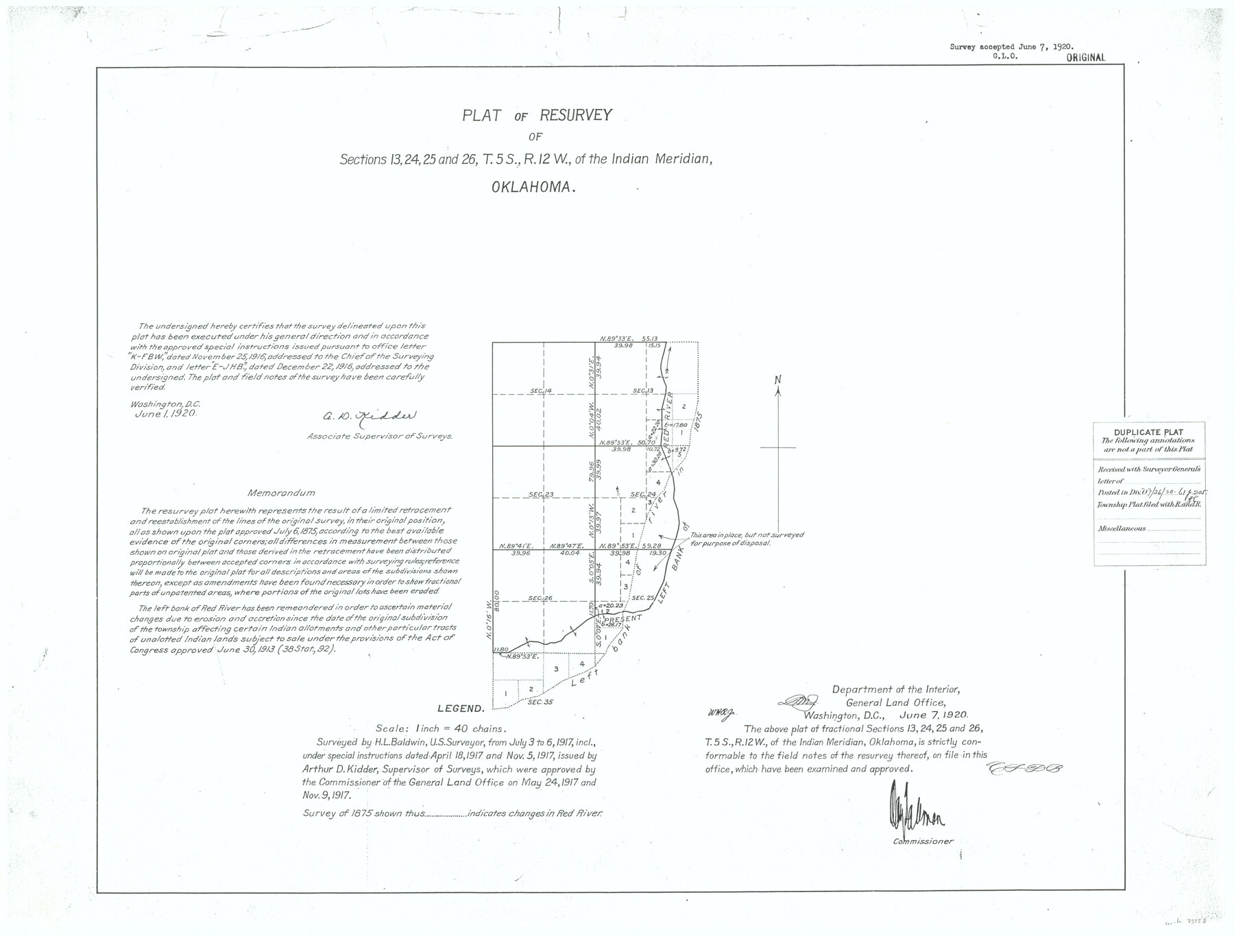
Plat of Resurvey of Sections 13, 24, 25 and 26, T. 5S., R. 12W., of the Indian Meridian, Oklahoma
-
Map/Doc
75158
-
Collection
General Map Collection
-
Object Dates
1917/7/6 (Creation Date)
-
Subjects
Texas Boundaries
-
Height x Width
18.3 x 24.1 inches
46.5 x 61.2 cm
Part of: General Map Collection
Starr County Sketch File 1

Print $4.00
- Digital $50.00
Starr County Sketch File 1
Size 10.3 x 5.1 inches
Map/Doc 36854
Flight Mission No. DAG-26K, Frame 81, Matagorda County

Print $20.00
- Digital $50.00
Flight Mission No. DAG-26K, Frame 81, Matagorda County
1953
Size 18.5 x 22.2 inches
Map/Doc 86586
Hutchinson County Rolled Sketch 44-16

Print $20.00
- Digital $50.00
Hutchinson County Rolled Sketch 44-16
2002
Size 24.0 x 36.0 inches
Map/Doc 77552
Brazoria County Rolled Sketch CL

Print $20.00
- Digital $50.00
Brazoria County Rolled Sketch CL
1934
Size 22.0 x 32.8 inches
Map/Doc 8463
Anderson County

Print $40.00
- Digital $50.00
Anderson County
1942
Size 54.2 x 47.3 inches
Map/Doc 66701
Nueces County Rolled Sketch 47

Print $20.00
- Digital $50.00
Nueces County Rolled Sketch 47
1953
Size 31.3 x 44.6 inches
Map/Doc 6886
Sabine Pass and Lake

Print $20.00
- Digital $50.00
Sabine Pass and Lake
1961
Size 46.7 x 28.1 inches
Map/Doc 69824
Montague County Working Sketch 25

Print $20.00
- Digital $50.00
Montague County Working Sketch 25
1955
Size 42.4 x 28.4 inches
Map/Doc 71091
Kinney County Working Sketch 50

Print $20.00
- Digital $50.00
Kinney County Working Sketch 50
1980
Size 19.4 x 26.9 inches
Map/Doc 70232
Val Verde County Working Sketch 26

Print $20.00
- Digital $50.00
Val Verde County Working Sketch 26
1936
Size 22.9 x 31.5 inches
Map/Doc 72161
Concho County Sketch File 24

Print $12.00
- Digital $50.00
Concho County Sketch File 24
1885
Size 11.1 x 8.4 inches
Map/Doc 19149
Montague County Rolled Sketch 9

Print $20.00
- Digital $50.00
Montague County Rolled Sketch 9
Size 29.1 x 39.4 inches
Map/Doc 6793
You may also like
Flight Mission No. CRK-5P, Frame 130, Refugio County

Print $20.00
- Digital $50.00
Flight Mission No. CRK-5P, Frame 130, Refugio County
1956
Size 18.6 x 22.5 inches
Map/Doc 86933
Flight Mission No. DCL-6C, Frame 53, Kenedy County

Print $20.00
- Digital $50.00
Flight Mission No. DCL-6C, Frame 53, Kenedy County
1943
Size 18.6 x 22.4 inches
Map/Doc 85895
Lee County Working Sketch 17

Print $20.00
- Digital $50.00
Lee County Working Sketch 17
1988
Size 31.8 x 32.2 inches
Map/Doc 70396
Marion County Rolled Sketch 2

Print $40.00
- Digital $50.00
Marion County Rolled Sketch 2
1954
Size 82.7 x 43.2 inches
Map/Doc 76446
Val Verde County Sketch File XXX1

Print $20.00
- Digital $50.00
Val Verde County Sketch File XXX1
Size 18.8 x 24.0 inches
Map/Doc 12547
[Block K5, Section 13]
![91451, [Block K5, Section 13], Twichell Survey Records](https://historictexasmaps.com/wmedia_w700/maps/91451-1.tif.jpg)
Print $3.00
- Digital $50.00
[Block K5, Section 13]
Size 11.4 x 10.4 inches
Map/Doc 91451
Roberts County Working Sketch 16

Print $20.00
- Digital $50.00
Roberts County Working Sketch 16
1975
Size 37.1 x 39.8 inches
Map/Doc 63542
Brewster County Rolled Sketch 114

Print $20.00
- Digital $50.00
Brewster County Rolled Sketch 114
1964
Size 11.0 x 18.3 inches
Map/Doc 5269
[G. & M. Block 5]
![91796, [G. & M. Block 5], Twichell Survey Records](https://historictexasmaps.com/wmedia_w700/maps/91796-1.tif.jpg)
Print $20.00
- Digital $50.00
[G. & M. Block 5]
Size 22.6 x 18.9 inches
Map/Doc 91796
General Highway Map, Houston County, Texas

Print $20.00
General Highway Map, Houston County, Texas
1961
Size 24.7 x 18.2 inches
Map/Doc 79525
[Map of Texas and Pacific Blocks from Brazos River westward through Palo Pinto, Stephens, Shackelford, Jones, Callahan, Taylor, Fisher, Nolan and Mitchell Counties]
![93460, [Map of Texas and Pacific Blocks from Brazos River westward through Palo Pinto, Stephens, Shackelford, Jones, Callahan, Taylor, Fisher, Nolan and Mitchell Counties], General Map Collection](https://historictexasmaps.com/wmedia_w700/maps/93460.tif.jpg)
Print $40.00
- Digital $50.00
[Map of Texas and Pacific Blocks from Brazos River westward through Palo Pinto, Stephens, Shackelford, Jones, Callahan, Taylor, Fisher, Nolan and Mitchell Counties]
Size 87.1 x 18.8 inches
Map/Doc 93460
Medina County Rolled Sketch 1

Print $20.00
- Digital $50.00
Medina County Rolled Sketch 1
Size 46.2 x 43.3 inches
Map/Doc 9503