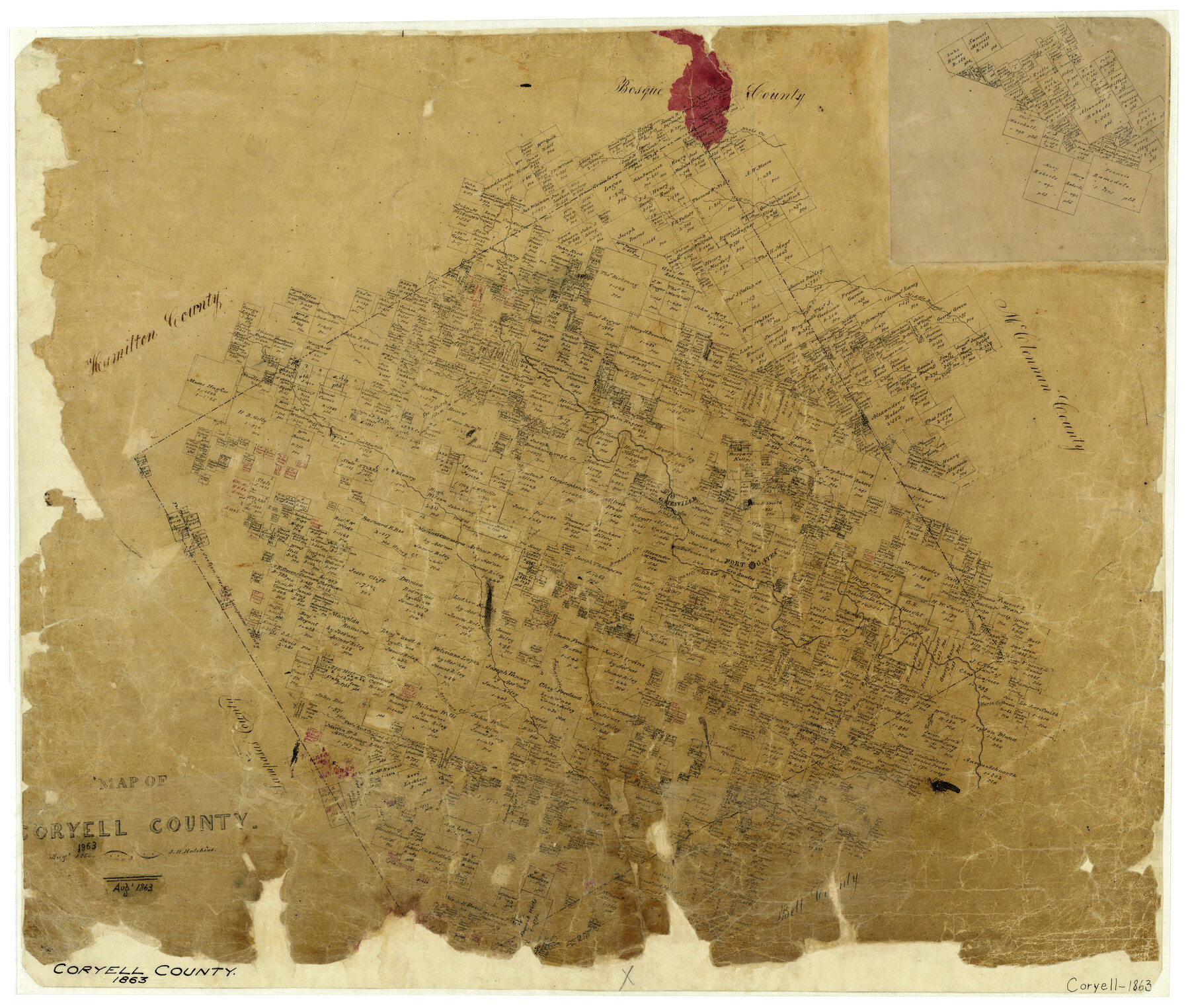
Map of Coryell County
-
Map/Doc
3443
-
Collection
General Map Collection
-
Object Dates
8/1863 (Creation Date)
-
People and Organizations
J.H. Hutchins (Draftsman)
-
Counties
Coryell
-
Subjects
County
-
Height x Width
23.1 x 27.4 inches
58.7 x 69.6 cm
-
Features
Dodd's Creek
Owl Creek
Cowhouse Creek
Beehouse Creek
Table Rock Creek
Louder's Creek
Henson's Creek
Holbert's Creek
Horse Creek
Fort Gates
Leon River
Snake Creek
Neel's Creek
Draper's Creek
Honey Creek
Gray's Creek
Gatesville
Coryell Creek
Bluff Creek
Plum Creek
Eagle Creek
Cave Creek
Middle Bosque River
Hog Creek
Part of: General Map Collection
Reagan County Rolled Sketch 38

Print $20.00
- Digital $50.00
Reagan County Rolled Sketch 38
1964
Size 39.2 x 40.5 inches
Map/Doc 9830
Burnet County Sketch File 18

Print $4.00
- Digital $50.00
Burnet County Sketch File 18
1873
Size 8.3 x 6.5 inches
Map/Doc 16708

Flight Mission No. CGI-4N, Frame 179, Cameron County

Print $20.00
- Digital $50.00
Flight Mission No. CGI-4N, Frame 179, Cameron County
1955
Size 18.5 x 22.2 inches
Map/Doc 84682
Starr County Sketch File 48

Print $20.00
- Digital $50.00
Starr County Sketch File 48
1950
Size 22.3 x 10.8 inches
Map/Doc 12345
Menard County Boundary File 2a

Print $80.00
- Digital $50.00
Menard County Boundary File 2a
Size 36.4 x 12.2 inches
Map/Doc 57065
Flight Mission No. BRA-7M, Frame 10, Jefferson County

Print $20.00
- Digital $50.00
Flight Mission No. BRA-7M, Frame 10, Jefferson County
1953
Size 18.7 x 22.4 inches
Map/Doc 85461
Reagan County Working Sketch 14a

Print $20.00
- Digital $50.00
Reagan County Working Sketch 14a
1949
Size 25.9 x 15.2 inches
Map/Doc 71854
Uvalde County Rolled Sketch 24

Print $20.00
- Digital $50.00
Uvalde County Rolled Sketch 24
2014
Size 16.2 x 16.1 inches
Map/Doc 93722
Brazoria County Working Sketch 8

Print $20.00
- Digital $50.00
Brazoria County Working Sketch 8
1932
Size 25.9 x 21.5 inches
Map/Doc 67493
Pecos County Rolled Sketch 100

Print $20.00
- Digital $50.00
Pecos County Rolled Sketch 100
1936
Size 45.2 x 25.2 inches
Map/Doc 9712
Right of Way and Track Map, Texas & New Orleans R.R. Co. operated by the T. & N. O. R.R. Co., Dallas-Sabine Branch

Print $40.00
- Digital $50.00
Right of Way and Track Map, Texas & New Orleans R.R. Co. operated by the T. & N. O. R.R. Co., Dallas-Sabine Branch
1918
Size 24.9 x 56.9 inches
Map/Doc 64630
You may also like
Oldham County Sketch File 15

Print $6.00
- Digital $50.00
Oldham County Sketch File 15
1904
Size 11.2 x 8.5 inches
Map/Doc 33261
Trinity County Sketch File 34

Print $20.00
- Digital $50.00
Trinity County Sketch File 34
Size 15.9 x 20.3 inches
Map/Doc 12491
Miller-Stevens Subdivision Section 16, Block B

Print $20.00
- Digital $50.00
Miller-Stevens Subdivision Section 16, Block B
1944
Size 24.2 x 39.8 inches
Map/Doc 92401
San Saba County

Print $20.00
- Digital $50.00
San Saba County
1987
Size 46.3 x 42.5 inches
Map/Doc 73284
Burleson County Working Sketch 18

Print $20.00
- Digital $50.00
Burleson County Working Sketch 18
1980
Size 17.6 x 7.8 inches
Map/Doc 67737
Panola County Working Sketch 10

Print $20.00
- Digital $50.00
Panola County Working Sketch 10
1943
Map/Doc 71419
Starr County Working Sketch 1

Print $40.00
- Digital $50.00
Starr County Working Sketch 1
Size 26.7 x 65.5 inches
Map/Doc 63917
Frio County Working Sketch 13

Print $20.00
- Digital $50.00
Frio County Working Sketch 13
1954
Size 23.3 x 35.5 inches
Map/Doc 69287
Flight Mission No. CRC-3R, Frame 210, Chambers County

Print $20.00
- Digital $50.00
Flight Mission No. CRC-3R, Frame 210, Chambers County
1956
Size 18.6 x 22.3 inches
Map/Doc 84865
Liberty County Working Sketch 88

Print $20.00
- Digital $50.00
Liberty County Working Sketch 88
1991
Size 19.6 x 38.8 inches
Map/Doc 70548
Travis County Working Sketch 43

Print $20.00
- Digital $50.00
Travis County Working Sketch 43
1974
Size 24.1 x 24.6 inches
Map/Doc 69427
Fort Bend County Working Sketch 4

Print $20.00
- Digital $50.00
Fort Bend County Working Sketch 4
1909
Size 23.5 x 34.8 inches
Map/Doc 69210