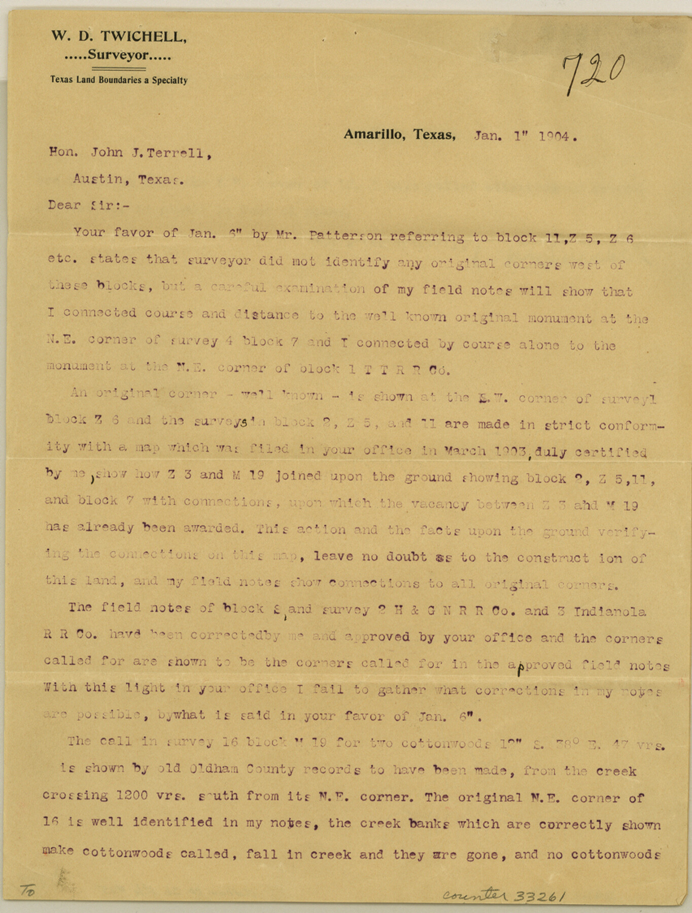
Oldham County Sketch File 15
[Letter regarding multiple Blocks in the county]
-
Map/Doc
33261
-
Collection
General Map Collection
-
Object Dates
1/1/1904 (Creation Date)
-
People and Organizations
W.D. Twichell (Surveyor/Engineer)
-
Counties
Oldham
-
Subjects
Surveying Sketch File
-
Height x Width
11.2 x 8.5 inches
28.5 x 21.6 cm
-
Medium
paper, print
Part of: General Map Collection
Brewster County Rolled Sketch 57

Print $20.00
- Digital $50.00
Brewster County Rolled Sketch 57
1937
Size 43.1 x 37.8 inches
Map/Doc 8482
Lampasas County Sketch File 16 1/2

Print $4.00
- Digital $50.00
Lampasas County Sketch File 16 1/2
Size 8.4 x 8.6 inches
Map/Doc 29428
Calhoun County Rolled Sketch 12

Print $40.00
- Digital $50.00
Calhoun County Rolled Sketch 12
1940
Size 37.9 x 54.6 inches
Map/Doc 66845
Brooks County Rolled Sketch 29

Print $20.00
- Digital $50.00
Brooks County Rolled Sketch 29
1947
Size 31.3 x 22.9 inches
Map/Doc 5347
San Jacinto River, Water Sheds of the San Jacinto River and Buffalo Bayou

Print $4.00
- Digital $50.00
San Jacinto River, Water Sheds of the San Jacinto River and Buffalo Bayou
Size 28.8 x 20.0 inches
Map/Doc 65149

Johnson County Rolled Sketch B

Print $20.00
- Digital $50.00
Johnson County Rolled Sketch B
1891
Size 28.2 x 38.9 inches
Map/Doc 6449
Baylor County Working Sketch 2

Print $20.00
- Digital $50.00
Baylor County Working Sketch 2
1919
Size 22.4 x 24.1 inches
Map/Doc 67287
Eastland County Boundary File 26

Print $24.00
- Digital $50.00
Eastland County Boundary File 26
Size 7.8 x 3.5 inches
Map/Doc 52801
Dickens County Rolled Sketch P

Print $20.00
- Digital $50.00
Dickens County Rolled Sketch P
1917
Size 41.2 x 36.9 inches
Map/Doc 8782
Map of City of Lampasas, Texas

Print $20.00
- Digital $50.00
Map of City of Lampasas, Texas
1935
Size 26.1 x 17.6 inches
Map/Doc 4827
Williamson County Sketch File 11

Print $4.00
- Digital $50.00
Williamson County Sketch File 11
Size 8.2 x 9.2 inches
Map/Doc 40324
You may also like
Montgomery County Working Sketch 3

Print $20.00
- Digital $50.00
Montgomery County Working Sketch 3
1918
Size 16.5 x 14.1 inches
Map/Doc 71109
[Floyd County School Land Lgs. 180-183, Fisher County School Land Lgs. 105-108, and part of Blk. V]
![90191, [Floyd County Schoo Land Lgs. 180-183, Fisher County School Land Lgs. 105-108, and part of Blk. V], Twichell Survey Records](https://historictexasmaps.com/wmedia_w700/maps/90191-1.tif.jpg)
Print $2.00
- Digital $50.00
[Floyd County School Land Lgs. 180-183, Fisher County School Land Lgs. 105-108, and part of Blk. V]
Size 8.8 x 10.3 inches
Map/Doc 90191
[E. L. & R. R. RR. Co. Block D7 and G. H. & H. RR. Co. Block A1]
![91859, [E. L. & R. R. RR. Co. Block D7 and G. H. & H. RR. Co. Block A1], Twichell Survey Records](https://historictexasmaps.com/wmedia_w700/maps/91859-1.tif.jpg)
Print $20.00
- Digital $50.00
[E. L. & R. R. RR. Co. Block D7 and G. H. & H. RR. Co. Block A1]
Size 19.0 x 25.2 inches
Map/Doc 91859
Erath County Working Sketch 9

Print $20.00
- Digital $50.00
Erath County Working Sketch 9
1939
Size 18.6 x 14.8 inches
Map/Doc 69090
Dawson County Rolled Sketch 10

Print $20.00
- Digital $50.00
Dawson County Rolled Sketch 10
1954
Size 44.5 x 37.9 inches
Map/Doc 8774
Montague County Working Sketch 3

Print $20.00
- Digital $50.00
Montague County Working Sketch 3
1912
Size 20.5 x 15.4 inches
Map/Doc 71069
San Augustine County Working Sketch 13

Print $20.00
- Digital $50.00
San Augustine County Working Sketch 13
1952
Size 34.0 x 27.6 inches
Map/Doc 63701
Visitors' Map of Galveston also showing County Shell Road to Houston

Print $20.00
- Digital $50.00
Visitors' Map of Galveston also showing County Shell Road to Houston
Size 19.6 x 23.9 inches
Map/Doc 95319
The Judicial District/County of Neches. Abolished, Spring 1842

Print $20.00
The Judicial District/County of Neches. Abolished, Spring 1842
2020
Size 15.5 x 21.7 inches
Map/Doc 96339
Map of Mason County, Texas

Print $20.00
- Digital $50.00
Map of Mason County, Texas
Size 26.0 x 19.2 inches
Map/Doc 404
El Paso County Rolled Sketch 51

Print $40.00
- Digital $50.00
El Paso County Rolled Sketch 51
Size 42.9 x 75.3 inches
Map/Doc 8877
Aransas County Rolled Sketch 1

Print $40.00
- Digital $50.00
Aransas County Rolled Sketch 1
1930
Size 54.3 x 17.0 inches
Map/Doc 8914