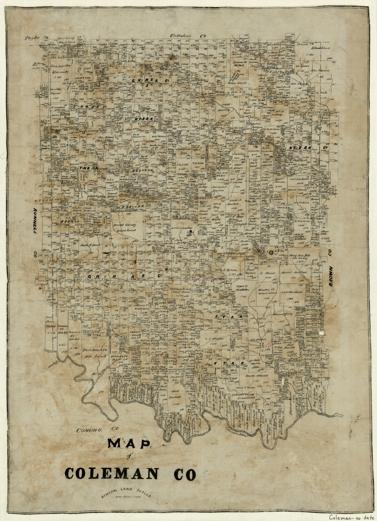
Map of Coleman County
-
Map/Doc
3408
-
Collection
General Map Collection
-
Counties
Coleman
-
Subjects
County
-
Height x Width
26.8 x 19.8 inches
68.1 x 50.3 cm
-
Features
Bluff Creek
Cow Creek
Indian Creek
Hog Creek
Jim Ned Creek
Hord's Creek
Coleman City
Santa Anna's Peak
Polk Creek
Mukewater Creek
Camp Creek
Davids Creek
Elm Creek
Concho River
Colorado River
Robinson's Mountain
Part of: General Map Collection
Jefferson County Working Sketch 13

Print $20.00
- Digital $50.00
Jefferson County Working Sketch 13
1948
Size 13.5 x 20.1 inches
Map/Doc 66556
McMullen County Sketch File 13

Print $4.00
- Digital $50.00
McMullen County Sketch File 13
1876
Size 10.0 x 8.0 inches
Map/Doc 31359
Haskell County Sketch File 25

Print $20.00
- Digital $50.00
Haskell County Sketch File 25
1888
Size 16.8 x 21.8 inches
Map/Doc 11748
Jasper County Working Sketch 29

Print $20.00
- Digital $50.00
Jasper County Working Sketch 29
1956
Size 20.6 x 31.4 inches
Map/Doc 66491
Webb County Sketch File 6-1

Print $6.00
- Digital $50.00
Webb County Sketch File 6-1
1877
Size 9.8 x 12.7 inches
Map/Doc 39737
Flight Mission No. CUG-3P, Frame 20, Kleberg County

Print $20.00
- Digital $50.00
Flight Mission No. CUG-3P, Frame 20, Kleberg County
1956
Size 18.4 x 22.3 inches
Map/Doc 86230
Bowles's New Pocket Map of North America, divided into it's Provinces, Colonies, &c.

Print $20.00
- Digital $50.00
Bowles's New Pocket Map of North America, divided into it's Provinces, Colonies, &c.
1776
Size 21.8 x 29.0 inches
Map/Doc 93732
Erath County Working Sketch 45

Print $20.00
- Digital $50.00
Erath County Working Sketch 45
1982
Size 25.5 x 24.8 inches
Map/Doc 69126
[Surveys along Seco Creek]
![268, [Surveys along Seco Creek], General Map Collection](https://historictexasmaps.com/wmedia_w700/maps/268.tif.jpg)
Print $3.00
- Digital $50.00
[Surveys along Seco Creek]
1847
Size 14.6 x 9.8 inches
Map/Doc 268
Marion County Sketch File 18

Print $77.00
- Digital $50.00
Marion County Sketch File 18
1913
Size 10.3 x 12.3 inches
Map/Doc 30590
Swisher County Sketch File 10

Print $6.00
- Digital $50.00
Swisher County Sketch File 10
1936
Size 11.0 x 15.9 inches
Map/Doc 37631
Mills County Boundary File 7

Print $2.00
- Digital $50.00
Mills County Boundary File 7
Size 14.2 x 8.6 inches
Map/Doc 57312
You may also like
Panola County Rolled Sketch 7

Print $20.00
- Digital $50.00
Panola County Rolled Sketch 7
Size 18.6 x 23.4 inches
Map/Doc 7200
[SW Corner of Lynn County]
![92903, [SW Corner of Lynn County], Twichell Survey Records](https://historictexasmaps.com/wmedia_w700/maps/92903-1.tif.jpg)
Print $20.00
- Digital $50.00
[SW Corner of Lynn County]
1954
Size 32.2 x 31.1 inches
Map/Doc 92903
Hood County Sketch File 12

Print $35.00
- Digital $50.00
Hood County Sketch File 12
Size 9.0 x 9.7 inches
Map/Doc 26590

Aransas County NRC Article 33.136 Sketch 13

Print $24.00
- Digital $50.00
Aransas County NRC Article 33.136 Sketch 13
Size 24.0 x 36.0 inches
Map/Doc 94514
Cottle County Sketch File AA1

Print $95.00
- Digital $50.00
Cottle County Sketch File AA1
1895
Size 9.4 x 4.2 inches
Map/Doc 19398
Dimmit County Sketch File 22

Print $47.00
- Digital $50.00
Dimmit County Sketch File 22
1906
Size 9.3 x 8.6 inches
Map/Doc 21129
Baylor County Sketch File 17

Print $4.00
- Digital $50.00
Baylor County Sketch File 17
1872
Size 12.8 x 8.5 inches
Map/Doc 14189
Resurvey of H.L. Upshur's April 23, 1853 meanders of the Colorado River from the NE corner of Isaac Decker league to the Congress Avenue Bridge

Print $20.00
- Digital $50.00
Resurvey of H.L. Upshur's April 23, 1853 meanders of the Colorado River from the NE corner of Isaac Decker league to the Congress Avenue Bridge
1915
Size 24.0 x 16.3 inches
Map/Doc 75773
Ellis County Boundary File 6

Print $22.00
- Digital $50.00
Ellis County Boundary File 6
Size 8.6 x 6.0 inches
Map/Doc 52992
Travis County State Real Property Sketch 9

Print $20.00
- Digital $50.00
Travis County State Real Property Sketch 9
2002
Size 30.6 x 42.5 inches
Map/Doc 82560
Sabine County Working Sketch 6

Print $20.00
- Digital $50.00
Sabine County Working Sketch 6
1918
Size 17.5 x 17.6 inches
Map/Doc 63677