Webb County Sketch File 6-1
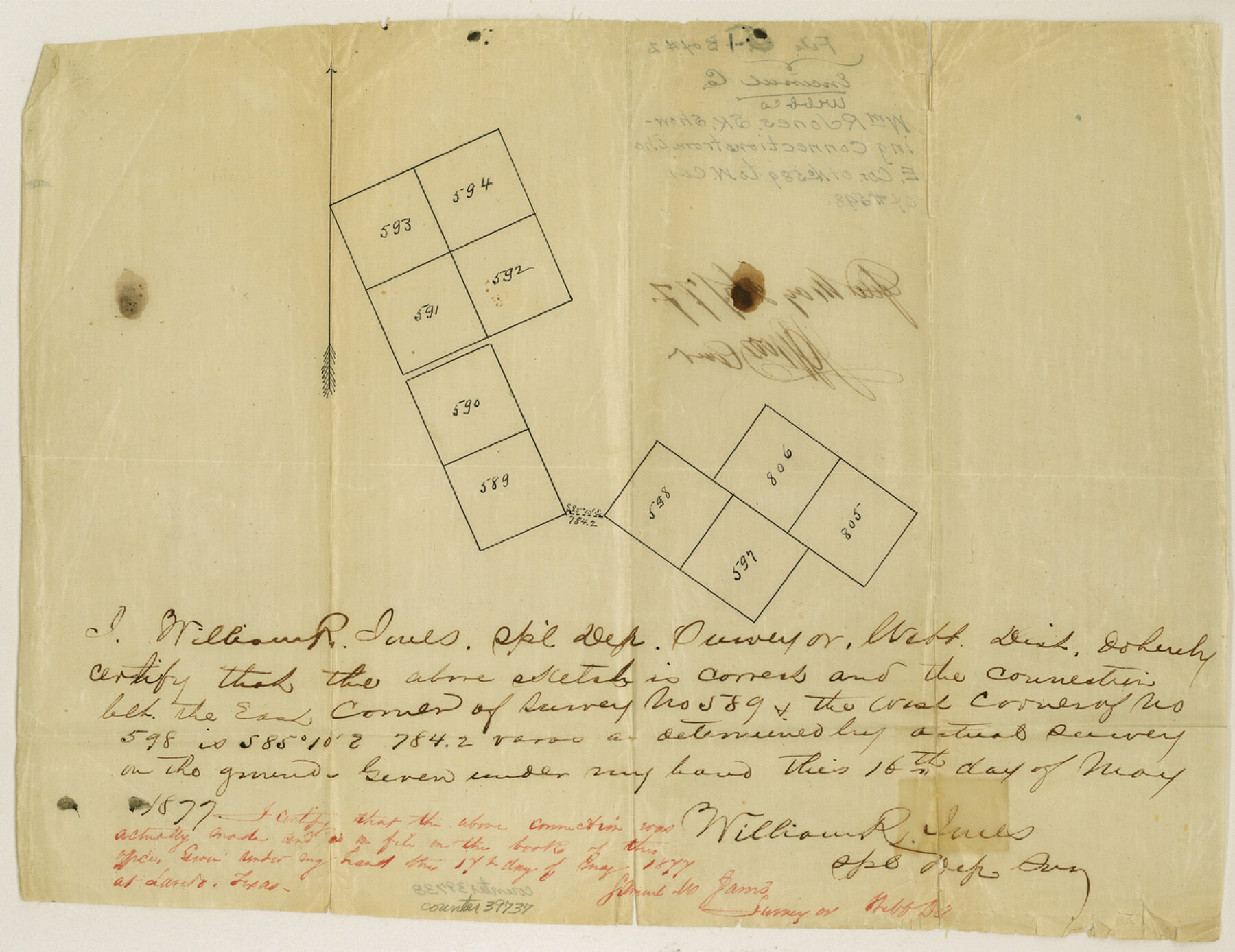
[Sketch showing connection from the east corner of survey no. 589 to the west corner of survey no. 598]
-
Map/Doc
39737
-
Collection
General Map Collection
-
Object Dates
5/16/1877 (Creation Date)
5/26/1877 (File Date)
-
People and Organizations
William R. Jones (Surveyor/Engineer)
-
Counties
Webb
-
Subjects
Surveying Sketch File
-
Height x Width
9.8 x 12.7 inches
24.9 x 32.3 cm
-
Medium
paper, print
Part of: General Map Collection
Hudspeth County Rolled Sketch 66

Print $20.00
- Digital $50.00
Hudspeth County Rolled Sketch 66
1973
Size 11.7 x 18.2 inches
Map/Doc 6263
Harris County Rolled Sketch P57

Print $20.00
- Digital $50.00
Harris County Rolled Sketch P57
1929
Size 29.6 x 37.5 inches
Map/Doc 9118
Hudspeth County Rolled Sketch 33

Print $40.00
- Digital $50.00
Hudspeth County Rolled Sketch 33
Size 59.0 x 24.9 inches
Map/Doc 8345
Schleicher County Rolled Sketch 17

Print $20.00
- Digital $50.00
Schleicher County Rolled Sketch 17
Size 27.9 x 20.6 inches
Map/Doc 7759
Flight Mission No. CLL-1N, Frame 84, Willacy County

Print $20.00
- Digital $50.00
Flight Mission No. CLL-1N, Frame 84, Willacy County
1954
Size 18.5 x 22.2 inches
Map/Doc 87030
Austin Street Map & Guide

Digital $50.00
Austin Street Map & Guide
Size 35.3 x 23.2 inches
Map/Doc 94434
Crosby County Rolled Sketch D

Print $20.00
- Digital $50.00
Crosby County Rolled Sketch D
Size 23.9 x 23.6 inches
Map/Doc 5643
Bandera County Working Sketch 30

Print $20.00
- Digital $50.00
Bandera County Working Sketch 30
1969
Size 29.9 x 37.4 inches
Map/Doc 67626
Jefferson Co.

Print $40.00
- Digital $50.00
Jefferson Co.
1978
Size 48.2 x 42.7 inches
Map/Doc 73196
Sabine County

Print $20.00
- Digital $50.00
Sabine County
1920
Size 44.6 x 35.1 inches
Map/Doc 16805
Real County Rolled Sketch 13

Print $20.00
- Digital $50.00
Real County Rolled Sketch 13
Size 23.0 x 34.0 inches
Map/Doc 9838
Upton County Sketch File 22

Print $4.00
- Digital $50.00
Upton County Sketch File 22
1927
Size 11.2 x 8.5 inches
Map/Doc 38877
You may also like
[Gonzales District]
![16837, [Gonzales District], General Map Collection](https://historictexasmaps.com/wmedia_w700/maps/16837.tif.jpg)
Print $20.00
- Digital $50.00
[Gonzales District]
1840
Size 42.8 x 37.0 inches
Map/Doc 16837
[Blocks T1, T2, T3, and Vicinity]
![90982, [Blocks T1, T2, T3, and Vicinity], Twichell Survey Records](https://historictexasmaps.com/wmedia_w700/maps/90982-1.tif.jpg)
Print $20.00
- Digital $50.00
[Blocks T1, T2, T3, and Vicinity]
Size 30.6 x 32.7 inches
Map/Doc 90982
Hardeman County Sketch File 7

Print $10.00
- Digital $50.00
Hardeman County Sketch File 7
Size 8.9 x 14.1 inches
Map/Doc 24997
Lampasas County Working Sketch 24

Print $20.00
- Digital $50.00
Lampasas County Working Sketch 24
Size 14.3 x 13.3 inches
Map/Doc 61796
Gaines County Rolled Sketch 15B

Print $40.00
- Digital $50.00
Gaines County Rolled Sketch 15B
Size 207.7 x 26.0 inches
Map/Doc 9037
Neches River, City of Lufkin

Print $20.00
- Digital $50.00
Neches River, City of Lufkin
1940
Size 37.5 x 29.7 inches
Map/Doc 65081
Flight Mission No. BQY-4M, Frame 59, Harris County

Print $20.00
- Digital $50.00
Flight Mission No. BQY-4M, Frame 59, Harris County
1953
Size 18.5 x 22.3 inches
Map/Doc 85268
Calhoun County Working Sketch Graphic Index

Print $40.00
- Digital $50.00
Calhoun County Working Sketch Graphic Index
1948
Size 48.2 x 40.1 inches
Map/Doc 76484
Refugio County Texas

Print $20.00
- Digital $50.00
Refugio County Texas
1896
Size 20.3 x 26.9 inches
Map/Doc 3985

Galveston Bay, Texas

Print $20.00
- Digital $50.00
Galveston Bay, Texas
1905
Size 22.1 x 18.5 inches
Map/Doc 65389
Ft. Worth & Rio Grande Ry. west from Whiteland in McCulloch County

Print $20.00
- Digital $50.00
Ft. Worth & Rio Grande Ry. west from Whiteland in McCulloch County
Size 35.0 x 46.3 inches
Map/Doc 66908