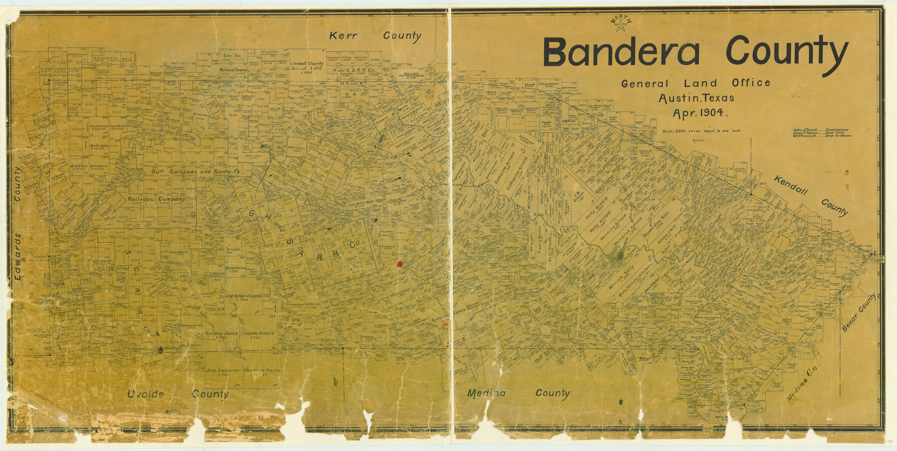
Bandera County
-
Map/Doc
3274
-
Collection
General Map Collection
-
Object Dates
1904 (Creation Date)
-
People and Organizations
Texas General Land Office (Publisher)
Morris (Compiler)
Morris (Draftsman)
-
Counties
Bandera
-
Subjects
County
-
Height x Width
30.7 x 61.0 inches
78.0 x 154.9 cm
-
Features
Hondo River
East Verde Creek
Middle Verde Creek
Cañon Creek
Old San Antonio Road
San Julian Creek
Leakey
Bandera Creek
Medina River
Coker Creek
Wards Creek
Commissioners Creek
Thomas Creek
Williams Creek
Verde Creek
Secco Creek
Turkey Creek
Sabinal River
Winans Creek
Bandera
Masons Creek
Privilege Creek
Spires Creek
Medina
West Prong of Medina River
Rio Frio
C&M
Part of: General Map Collection
Map of the State of Texas published by the International and Gt. Northern Railroad

Print $20.00
- Digital $50.00
Map of the State of Texas published by the International and Gt. Northern Railroad
1881
Size 16.0 x 22.2 inches
Map/Doc 94092
Val Verde County Working Sketch 7

Print $20.00
- Digital $50.00
Val Verde County Working Sketch 7
1915
Size 21.9 x 19.5 inches
Map/Doc 72142
Flight Mission No. DQN-7K, Frame 37, Calhoun County

Print $20.00
- Digital $50.00
Flight Mission No. DQN-7K, Frame 37, Calhoun County
1953
Size 18.4 x 22.1 inches
Map/Doc 84475
Brazoria County NRC Article 33.136 Sketch 7

Print $21.00
- Digital $50.00
Brazoria County NRC Article 33.136 Sketch 7
2004
Size 23.7 x 33.3 inches
Map/Doc 82907
Amistad International Reservoir on Rio Grande 66

Print $20.00
- Digital $50.00
Amistad International Reservoir on Rio Grande 66
1949
Size 28.5 x 39.6 inches
Map/Doc 73351
Flight Mission No. DQN-3K, Frame 36, Calhoun County

Print $20.00
- Digital $50.00
Flight Mission No. DQN-3K, Frame 36, Calhoun County
1953
Size 18.6 x 22.2 inches
Map/Doc 84349
Ochiltree County Boundary File 8

Print $8.00
- Digital $50.00
Ochiltree County Boundary File 8
Size 11.2 x 8.7 inches
Map/Doc 57716
Starr County Working Sketch 6

Print $20.00
- Digital $50.00
Starr County Working Sketch 6
Size 24.3 x 16.2 inches
Map/Doc 63922
Jackson County Working Sketch 8

Print $20.00
- Digital $50.00
Jackson County Working Sketch 8
1980
Size 30.4 x 29.0 inches
Map/Doc 66456
United States - Gulf Coast - From Latitude 26° 33' to the Rio Grande Texas

Print $20.00
- Digital $50.00
United States - Gulf Coast - From Latitude 26° 33' to the Rio Grande Texas
1919
Size 27.5 x 18.4 inches
Map/Doc 72854
Stonewall County Working Sketch 25

Print $20.00
- Digital $50.00
Stonewall County Working Sketch 25
1973
Size 29.5 x 23.4 inches
Map/Doc 62332
Hudspeth County Working Sketch 11a

Print $20.00
- Digital $50.00
Hudspeth County Working Sketch 11a
1947
Size 40.9 x 37.9 inches
Map/Doc 66293
You may also like
Carte Nouvelle de la Mer du Sud

Print $20.00
- Digital $50.00
Carte Nouvelle de la Mer du Sud
1730
Size 25.8 x 39.6 inches
Map/Doc 93824
[Sketch showing I. & G. N. Block 8]
![91798, [Sketch showing I. & G. N. Block 8], Twichell Survey Records](https://historictexasmaps.com/wmedia_w700/maps/91798-1.tif.jpg)
Print $2.00
- Digital $50.00
[Sketch showing I. & G. N. Block 8]
1919
Size 7.6 x 12.6 inches
Map/Doc 91798
Gaines County Working Sketch 26

Print $20.00
- Digital $50.00
Gaines County Working Sketch 26
1983
Size 34.1 x 39.7 inches
Map/Doc 69326
Menard County Sketch File 14

Print $4.00
- Digital $50.00
Menard County Sketch File 14
1892
Size 12.8 x 8.2 inches
Map/Doc 31508
Map of Tascosa, Oldham County, Texas

Print $20.00
- Digital $50.00
Map of Tascosa, Oldham County, Texas
1886
Size 28.2 x 14.6 inches
Map/Doc 83011
Reagan County Rolled Sketch 21A

Print $20.00
- Digital $50.00
Reagan County Rolled Sketch 21A
1950
Size 34.8 x 43.4 inches
Map/Doc 9816
Dallas County Boundary File 8 and 8a

Print $4.00
- Digital $50.00
Dallas County Boundary File 8 and 8a
Size 11.2 x 8.7 inches
Map/Doc 52311
Flight Mission No. DCL-6C, Frame 78, Kenedy County

Print $20.00
- Digital $50.00
Flight Mission No. DCL-6C, Frame 78, Kenedy County
1943
Size 17.5 x 20.7 inches
Map/Doc 85920
La Salle County Sketch File 32

Print $16.00
- Digital $50.00
La Salle County Sketch File 32
1883
Size 14.3 x 8.8 inches
Map/Doc 29576
Goliad County Sketch File 13

Print $8.00
- Digital $50.00
Goliad County Sketch File 13
1856
Size 12.4 x 8.0 inches
Map/Doc 24239
Somervell County Sketch File 5

Print $95.00
- Digital $50.00
Somervell County Sketch File 5
1871
Size 8.8 x 7.7 inches
Map/Doc 36802
The University of Texas at Austin

The University of Texas at Austin
Size 16.0 x 17.1 inches
Map/Doc 94388