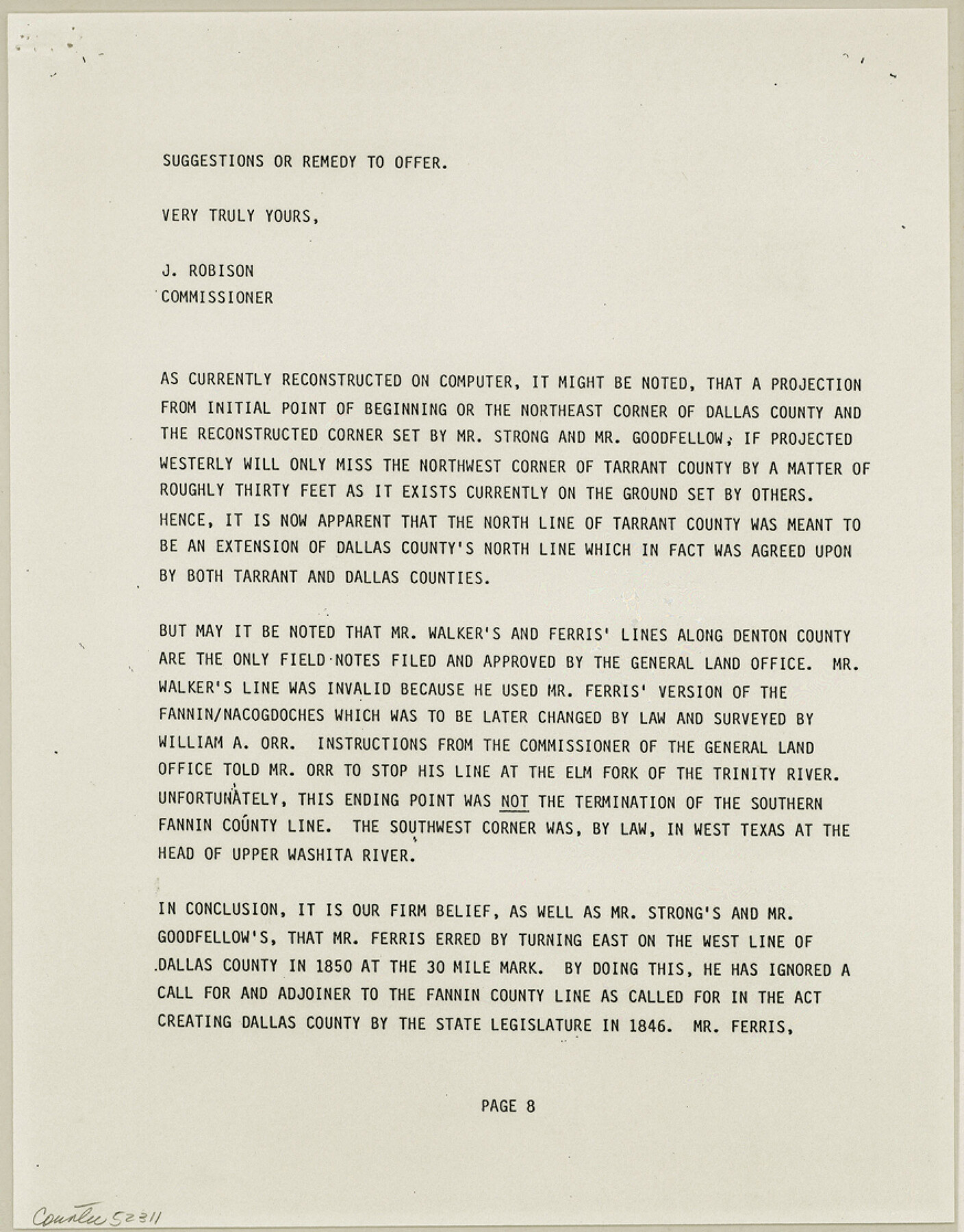
Dallas County Boundary File 8 and 8a
[Report on Dallas County North Line]
-
Map/Doc
52311
-
Collection
General Map Collection
-
Counties
Dallas
-
Subjects
County Boundaries
-
Height x Width
11.2 x 8.7 inches
28.5 x 22.1 cm
Part of: General Map Collection
Harris County NRC Article 33.136 Sketch 5

Print $20.00
- Digital $50.00
Harris County NRC Article 33.136 Sketch 5
2002
Size 22.2 x 34.1 inches
Map/Doc 77047
Blanco River, Austin Girl Scouts Council

Print $6.00
- Digital $50.00
Blanco River, Austin Girl Scouts Council
1938
Size 18.5 x 31.6 inches
Map/Doc 65058
Pecos County Working Sketch 53

Print $20.00
- Digital $50.00
Pecos County Working Sketch 53
1948
Size 37.6 x 25.8 inches
Map/Doc 71525
Flight Mission No. BQR-20K, Frame 14, Brazoria County

Print $20.00
- Digital $50.00
Flight Mission No. BQR-20K, Frame 14, Brazoria County
1952
Size 18.6 x 22.3 inches
Map/Doc 84116
Flight Mission No. DCL-5C, Frame 66, Kenedy County

Print $20.00
- Digital $50.00
Flight Mission No. DCL-5C, Frame 66, Kenedy County
1943
Size 18.4 x 22.3 inches
Map/Doc 85849
Intracoastal Waterway in Texas - Corpus Christi to Point Isabel including Arroyo Colorado to Mo. Pac. R.R. Bridge Near Harlingen

Print $20.00
- Digital $50.00
Intracoastal Waterway in Texas - Corpus Christi to Point Isabel including Arroyo Colorado to Mo. Pac. R.R. Bridge Near Harlingen
1934
Size 22.0 x 32.7 inches
Map/Doc 61880
Map of Uvalde Co.

Print $20.00
- Digital $50.00
Map of Uvalde Co.
1893
Size 42.7 x 42.5 inches
Map/Doc 16911

Flight Mission No. CGI-4N, Frame 174, Cameron County

Print $20.00
- Digital $50.00
Flight Mission No. CGI-4N, Frame 174, Cameron County
1955
Size 18.7 x 22.3 inches
Map/Doc 84677
Cass County Rolled Sketch 5B

Print $20.00
- Digital $50.00
Cass County Rolled Sketch 5B
1949
Size 23.5 x 16.4 inches
Map/Doc 5412
Matagorda County NRC Article 33.136 Sketch 5

Print $28.00
- Digital $50.00
Matagorda County NRC Article 33.136 Sketch 5
2009
Size 24.2 x 35.0 inches
Map/Doc 95006
Gaines County Sketch File 6

Print $20.00
- Digital $50.00
Gaines County Sketch File 6
1924
Size 20.9 x 21.3 inches
Map/Doc 11523
You may also like
Crosby County Boundary File 3

Print $2.00
- Digital $50.00
Crosby County Boundary File 3
Size 11.2 x 8.7 inches
Map/Doc 52002
Jeff Davis County Sketch File 22

Print $20.00
- Digital $50.00
Jeff Davis County Sketch File 22
1923
Size 19.4 x 25.0 inches
Map/Doc 11860
Rusk County Working Sketch 37c

Print $20.00
- Digital $50.00
Rusk County Working Sketch 37c
2007
Size 21.2 x 36.0 inches
Map/Doc 87498
Flight Mission No. DCL-6C, Frame 13, Kenedy County

Print $20.00
- Digital $50.00
Flight Mission No. DCL-6C, Frame 13, Kenedy County
1943
Size 18.6 x 22.3 inches
Map/Doc 85870
San Patricio County Rolled Sketch 43

Print $1233.00
- Digital $50.00
San Patricio County Rolled Sketch 43
Size 8.8 x 14.2 inches
Map/Doc 41814
Jeff Davis County Working Sketch 7

Print $20.00
- Digital $50.00
Jeff Davis County Working Sketch 7
1938
Size 30.4 x 39.9 inches
Map/Doc 66502
Coryell County Working Sketch 11

Print $20.00
- Digital $50.00
Coryell County Working Sketch 11
1949
Size 29.7 x 27.5 inches
Map/Doc 68218
Refugio County Boundary File 6a

Print $20.00
- Digital $50.00
Refugio County Boundary File 6a
Size 14.4 x 9.0 inches
Map/Doc 58262

Wilbarger County Boundary File 1b

Print $40.00
- Digital $50.00
Wilbarger County Boundary File 1b
Size 14.3 x 8.8 inches
Map/Doc 59943
University Land Field Notes for Block 13 in Crockett County, Block 11 in Reagan County, Block 12 in Crockett and Reagan Counties, Block 14 in Crockett and Upton Counties, and Block 15 in Upton County

University Land Field Notes for Block 13 in Crockett County, Block 11 in Reagan County, Block 12 in Crockett and Reagan Counties, Block 14 in Crockett and Upton Counties, and Block 15 in Upton County
Map/Doc 81717
Seagraves Chamber of Commerce Subdivision of Northeast Quarter of Southeast Quarter of Section 9, Block C-34, Gaines County, Texas

Print $20.00
- Digital $50.00
Seagraves Chamber of Commerce Subdivision of Northeast Quarter of Southeast Quarter of Section 9, Block C-34, Gaines County, Texas
1955
Size 16.7 x 18.2 inches
Map/Doc 92684