The University of Texas at Austin
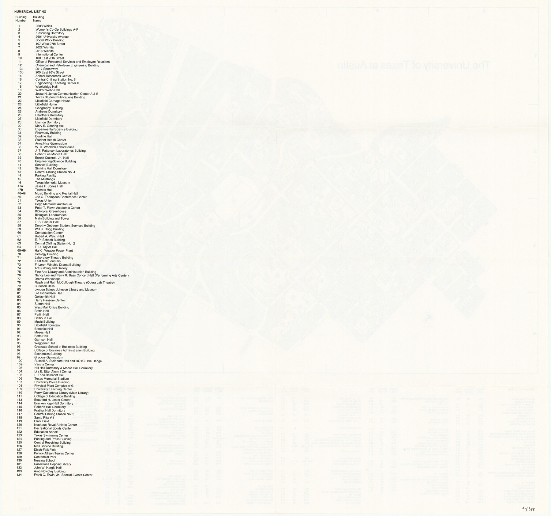
[Verso - campus building list]
-
Map/Doc
94388
-
Collection
General Map Collection
-
Counties
Travis
-
Height x Width
16.0 x 17.1 inches
40.6 x 43.4 cm
-
Medium
paper, etching/engraving/lithograph
-
Comments
For map of campus on recto, see 94387. For research only.
Related maps
The University of Texas at Austin

The University of Texas at Austin
Size 16.1 x 17.1 inches
Map/Doc 94387
Part of: General Map Collection
North Part of El Paso Co.

Print $20.00
- Digital $50.00
North Part of El Paso Co.
1977
Size 35.7 x 46.3 inches
Map/Doc 73141
Hidalgo County Sketch File 15

Print $12.00
- Digital $50.00
Hidalgo County Sketch File 15
1878
Size 10.1 x 7.9 inches
Map/Doc 26431
Red River County Working Sketch 36

Print $20.00
- Digital $50.00
Red River County Working Sketch 36
1964
Size 42.4 x 42.7 inches
Map/Doc 72019
Bexar County Rolled Sketch 1

Print $20.00
- Digital $50.00
Bexar County Rolled Sketch 1
Size 23.1 x 26.2 inches
Map/Doc 5134
La Salle County Sketch File 18

Print $4.00
- Digital $50.00
La Salle County Sketch File 18
1885
Size 8.5 x 15.5 inches
Map/Doc 29507

Flight Mission No. BRA-6M, Frame 89, Jefferson County

Print $20.00
- Digital $50.00
Flight Mission No. BRA-6M, Frame 89, Jefferson County
1953
Size 18.6 x 22.4 inches
Map/Doc 85432
Runnels County Rolled Sketch 31

Print $20.00
- Digital $50.00
Runnels County Rolled Sketch 31
Size 32.4 x 24.1 inches
Map/Doc 7519
Henderson County Sketch File 8

Print $6.00
- Digital $50.00
Henderson County Sketch File 8
1853
Size 9.8 x 8.2 inches
Map/Doc 26331
Hays County Sketch File 30

Print $12.00
- Digital $50.00
Hays County Sketch File 30
1938
Size 14.3 x 9.0 inches
Map/Doc 26255
Matagorda County Rolled Sketch 37A

Print $40.00
- Digital $50.00
Matagorda County Rolled Sketch 37A
Size 48.7 x 41.1 inches
Map/Doc 10195
Coleman County Sketch File 21

Print $4.00
- Digital $50.00
Coleman County Sketch File 21
1871
Size 12.7 x 8.3 inches
Map/Doc 18696
You may also like
Oldham County Working Sketch 10

Print $20.00
- Digital $50.00
Oldham County Working Sketch 10
1983
Size 29.6 x 44.3 inches
Map/Doc 71332
Township No. 5 South, Range No. 14 West, Indian Meridian, Oklahoma

Print $4.00
- Digital $50.00
Township No. 5 South, Range No. 14 West, Indian Meridian, Oklahoma
1928
Size 18.0 x 22.6 inches
Map/Doc 75141
Andrews County Sketch File 12

Print $8.00
- Digital $50.00
Andrews County Sketch File 12
1963
Size 11.1 x 8.5 inches
Map/Doc 12857
Scurry County Rolled Sketch 2

Print $20.00
- Digital $50.00
Scurry County Rolled Sketch 2
Size 44.0 x 44.9 inches
Map/Doc 9911
Texas Aerial Photo-Illustrated Map

Texas Aerial Photo-Illustrated Map
Size 21.3 x 28.3 inches
Map/Doc 94397
Kendall County Sketch File 13

Print $4.00
- Digital $50.00
Kendall County Sketch File 13
1860
Size 10.1 x 8.0 inches
Map/Doc 28699
Brooks County Rolled Sketch 26

Print $20.00
- Digital $50.00
Brooks County Rolled Sketch 26
1945
Size 33.7 x 43.3 inches
Map/Doc 8539
Mitchell County Sketch File 11

Print $6.00
- Digital $50.00
Mitchell County Sketch File 11
1910
Size 11.2 x 8.8 inches
Map/Doc 31700
Flight Mission No. DCL-5C, Frame 47, Kenedy County

Print $20.00
- Digital $50.00
Flight Mission No. DCL-5C, Frame 47, Kenedy County
1943
Size 18.6 x 22.3 inches
Map/Doc 85843
Brazoria County Rolled Sketch 38

Print $20.00
- Digital $50.00
Brazoria County Rolled Sketch 38
1949
Size 44.6 x 39.5 inches
Map/Doc 8460
Brazoria County Working Sketch 34

Print $20.00
- Digital $50.00
Brazoria County Working Sketch 34
1981
Size 15.8 x 19.0 inches
Map/Doc 67519
Flight Mission No. CRC-5R, Frame 26, Chambers County

Print $20.00
- Digital $50.00
Flight Mission No. CRC-5R, Frame 26, Chambers County
1956
Size 18.6 x 22.5 inches
Map/Doc 84948