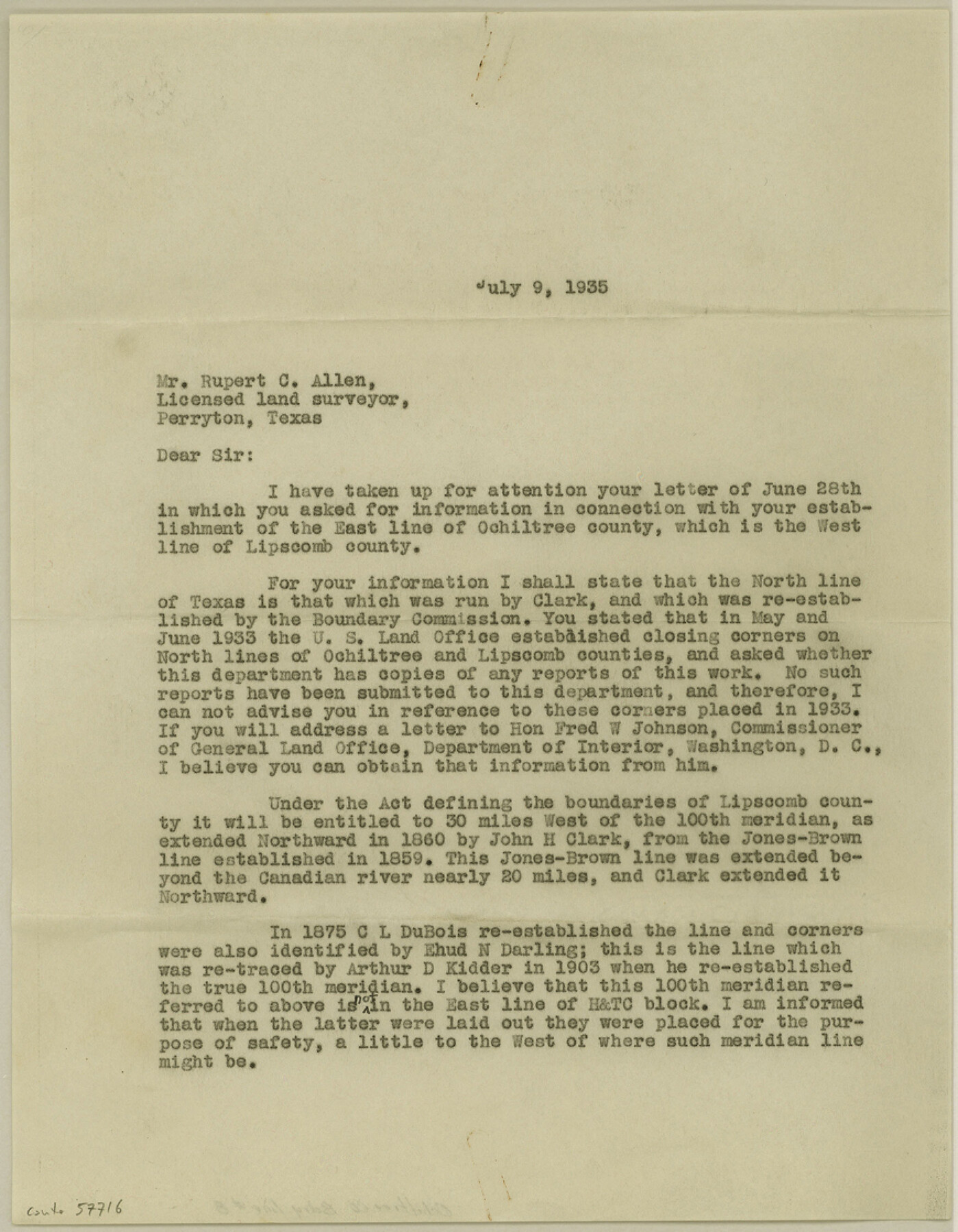
Ochiltree County Boundary File 8
[Letter regarding Ochiltree-Lipscomb Boundary line]
-
Map/Doc
57716
-
Collection
General Map Collection
-
Counties
Ochiltree
-
Subjects
County Boundaries
-
Height x Width
11.2 x 8.7 inches
28.4 x 22.1 cm
Part of: General Map Collection
Flight Mission No. CUG-2P, Frame 62, Kleberg County

Print $20.00
- Digital $50.00
Flight Mission No. CUG-2P, Frame 62, Kleberg County
1956
Size 18.5 x 18.5 inches
Map/Doc 86199
Parker County Sketch File 40

Print $4.00
- Digital $50.00
Parker County Sketch File 40
Size 8.1 x 12.7 inches
Map/Doc 33585
Map of Stephens County

Print $20.00
- Digital $50.00
Map of Stephens County
1897
Size 42.9 x 38.2 inches
Map/Doc 63044
Andrews County Rolled Sketch 35

Print $20.00
- Digital $50.00
Andrews County Rolled Sketch 35
Size 21.5 x 16.1 inches
Map/Doc 77177
Harris County Boundary File 39 (14)

Print $30.00
- Digital $50.00
Harris County Boundary File 39 (14)
Size 13.2 x 8.1 inches
Map/Doc 54344
El Paso County Sketch File 23

Print $4.00
- Digital $50.00
El Paso County Sketch File 23
Size 11.3 x 8.6 inches
Map/Doc 22068
Gregg County Rolled Sketch MHH1

Print $40.00
- Digital $50.00
Gregg County Rolled Sketch MHH1
1935
Size 167.4 x 23.1 inches
Map/Doc 9064
Flight Mission No. DAG-22K, Frame 73, Matagorda County

Print $20.00
- Digital $50.00
Flight Mission No. DAG-22K, Frame 73, Matagorda County
1953
Size 18.7 x 22.4 inches
Map/Doc 86460

Hardin County Sketch File 9a

Print $4.00
- Digital $50.00
Hardin County Sketch File 9a
1860
Size 9.9 x 8.4 inches
Map/Doc 25108
Flight Mission No. DAG-24K, Frame 43, Matagorda County

Print $20.00
- Digital $50.00
Flight Mission No. DAG-24K, Frame 43, Matagorda County
1953
Size 16.1 x 15.8 inches
Map/Doc 86530
Stonewall County Rolled Sketch 29

Print $20.00
- Digital $50.00
Stonewall County Rolled Sketch 29
Size 43.1 x 37.9 inches
Map/Doc 9969
You may also like
El Paso County Working Sketch 35

Print $20.00
- Digital $50.00
El Paso County Working Sketch 35
1977
Size 19.8 x 30.3 inches
Map/Doc 69057

Culberson County Sketch File EM

Print $7.00
- Digital $50.00
Culberson County Sketch File EM
Size 36.2 x 40.3 inches
Map/Doc 10359
Harris County Sketch File 25

Print $8.00
- Digital $50.00
Harris County Sketch File 25
Size 9.0 x 11.8 inches
Map/Doc 25389
Bosque County Working Sketch 2

Print $20.00
- Digital $50.00
Bosque County Working Sketch 2
Size 19.7 x 19.6 inches
Map/Doc 67435
Duval County Sketch File 53

Print $4.00
- Digital $50.00
Duval County Sketch File 53
1937
Size 11.6 x 7.3 inches
Map/Doc 21416
Starr County Rolled Sketch 29

Print $20.00
- Digital $50.00
Starr County Rolled Sketch 29
1857
Size 35.1 x 30.0 inches
Map/Doc 7812
Dallas County Sketch File 5

Print $18.00
- Digital $50.00
Dallas County Sketch File 5
1858
Size 10.5 x 8.4 inches
Map/Doc 20400
Wichita County Sketch File D

Print $22.00
- Digital $50.00
Wichita County Sketch File D
1919
Size 12.0 x 8.6 inches
Map/Doc 40061
Travis County Working Sketch 54

Print $20.00
- Digital $50.00
Travis County Working Sketch 54
1976
Size 30.1 x 32.0 inches
Map/Doc 69438

Medina County Rolled Sketch 5

Print $40.00
- Digital $50.00
Medina County Rolled Sketch 5
1948
Size 52.0 x 47.1 inches
Map/Doc 9505