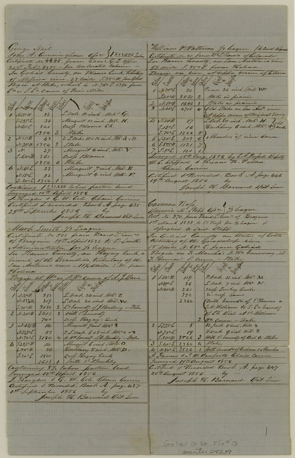
Goliad County Sketch File 13
[Goliad District Quarterly Report]
-
Map/Doc
24239
-
Collection
General Map Collection
-
Object Dates
1856/11/1 (Creation Date)
1856/12/12 (File Date)
1856/9/29 (Survey Date)
1856/8/19 (Survey Date)
1856/6/9 (Survey Date)
-
People and Organizations
Joseph H. Barnard (Surveyor/Engineer)
J. Hughes (Chainman)
G.W. Cole (Chainman)
W.C. Clifford (Chainman)
Hiram B. Pullen (Chainman)
J. Farmer (Chainman)
T.W. Danforth (Chainman)
J.T. Kilgore (Chainman)
W. Kennedy (Chainman)
J. Noble (Chainman)
W.S. McCampbell (Chainman)
J.H. Barnard (Chainman)
-
Counties
Goliad Karnes
-
Subjects
Surveying Sketch File
-
Height x Width
12.4 x 8.0 inches
31.5 x 20.3 cm
-
Medium
paper, manuscript
-
Features
Blanco Creek
Coleto Creek
Guadalupe River
Mugirna Creek
Part of: General Map Collection
McMullen County Rolled Sketch 9

Print $20.00
- Digital $50.00
McMullen County Rolled Sketch 9
Size 34.4 x 40.9 inches
Map/Doc 6726
Flight Mission No. CUG-2P, Frame 81, Kleberg County

Print $20.00
- Digital $50.00
Flight Mission No. CUG-2P, Frame 81, Kleberg County
1956
Size 18.7 x 22.2 inches
Map/Doc 86213
Kendall County Sketch File 22

Print $20.00
- Digital $50.00
Kendall County Sketch File 22
1926
Size 17.0 x 25.8 inches
Map/Doc 11910
Coryell County Sketch File 16

Print $4.00
- Digital $50.00
Coryell County Sketch File 16
Size 6.5 x 5.4 inches
Map/Doc 19373
Winkler County Rolled Sketch 4

Print $40.00
- Digital $50.00
Winkler County Rolled Sketch 4
1927
Size 59.1 x 39.5 inches
Map/Doc 10147
Map of Swisher County

Print $20.00
- Digital $50.00
Map of Swisher County
1898
Size 36.4 x 32.7 inches
Map/Doc 16889
Orange County Working Sketch 8

Print $20.00
- Digital $50.00
Orange County Working Sketch 8
1922
Size 20.7 x 24.3 inches
Map/Doc 71340
Grayson County Sketch File 24

Print $4.00
- Digital $50.00
Grayson County Sketch File 24
1872
Size 8.1 x 10.0 inches
Map/Doc 24505
Presidio County Working Sketch 29a

Print $20.00
- Digital $50.00
Presidio County Working Sketch 29a
1946
Size 38.9 x 31.6 inches
Map/Doc 71706
Nautical Chart 152-SC - Galveston Bay, Texas

Print $20.00
- Digital $50.00
Nautical Chart 152-SC - Galveston Bay, Texas
1972
Size 14.9 x 32.8 inches
Map/Doc 69889
Anderson County Working Sketch 34

Print $20.00
- Digital $50.00
Anderson County Working Sketch 34
1967
Size 32.1 x 47.7 inches
Map/Doc 67034
Gaines County Rolled Sketch 17A

Print $40.00
- Digital $50.00
Gaines County Rolled Sketch 17A
1950
Size 23.9 x 61.6 inches
Map/Doc 9040
You may also like

The Mexican Municipality of Brazoria. December 28, 1834

Print $20.00
The Mexican Municipality of Brazoria. December 28, 1834
2020
Size 16.5 x 21.7 inches
Map/Doc 96017
Bee County Sketch File 34

Print $14.00
Bee County Sketch File 34
2022
Size 11.0 x 8.5 inches
Map/Doc 97030
[Blocks C4, S1, K and C3 in Northern Hale/Southern Swisher Counties]
![91858, [Blocks C4, S1, K and C3 in Northern Hale/Southern Swisher Counties], Twichell Survey Records](https://historictexasmaps.com/wmedia_w700/maps/91858-1.tif.jpg)
Print $2.00
- Digital $50.00
[Blocks C4, S1, K and C3 in Northern Hale/Southern Swisher Counties]
1906
Size 15.0 x 8.7 inches
Map/Doc 91858
Upton County Working Sketch 27

Print $20.00
- Digital $50.00
Upton County Working Sketch 27
1954
Size 24.2 x 33.9 inches
Map/Doc 69523
Hudspeth County Working Sketch 7

Print $40.00
- Digital $50.00
Hudspeth County Working Sketch 7
1935
Size 92.4 x 33.6 inches
Map/Doc 66288
Map of Yoakum County Texas

Print $20.00
- Digital $50.00
Map of Yoakum County Texas
1938
Size 21.0 x 26.8 inches
Map/Doc 92447
Dawson County Working Sketch 15

Print $20.00
- Digital $50.00
Dawson County Working Sketch 15
1955
Size 28.2 x 24.8 inches
Map/Doc 68559
Presidio County Rolled Sketch 59

Print $20.00
- Digital $50.00
Presidio County Rolled Sketch 59
Size 27.6 x 18.2 inches
Map/Doc 7352
19th Congressional District of Texas

Print $20.00
- Digital $50.00
19th Congressional District of Texas
Size 33.1 x 28.9 inches
Map/Doc 92610
Comanche County Sketch File 10

Print $4.00
- Digital $50.00
Comanche County Sketch File 10
1859
Size 8.4 x 16.0 inches
Map/Doc 19070
Grayson County Working Sketch 26

Print $20.00
- Digital $50.00
Grayson County Working Sketch 26
1984
Size 27.7 x 38.8 inches
Map/Doc 63265