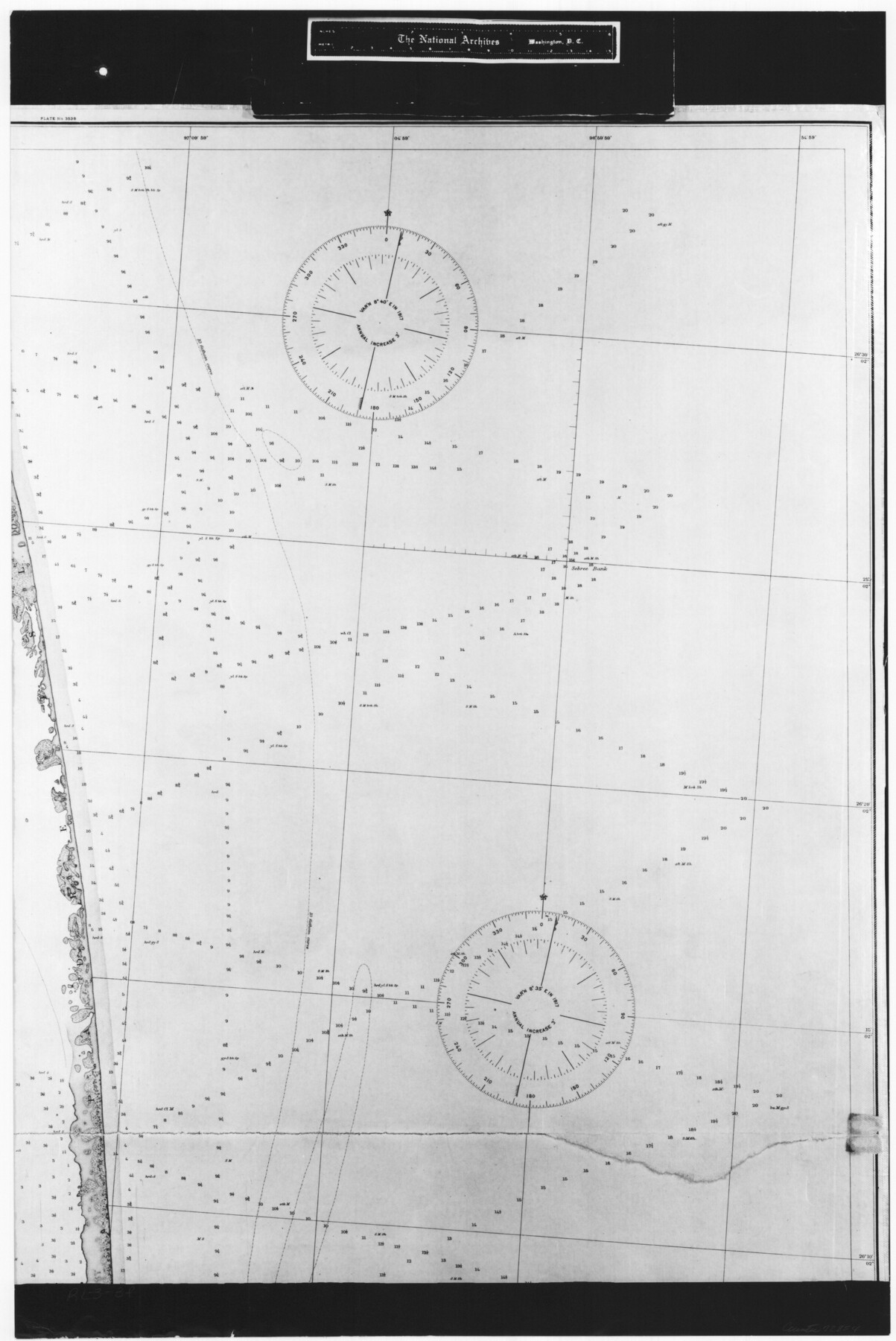
United States - Gulf Coast - From Latitude 26° 33' to the Rio Grande Texas
RL-3-3f
-
Map/Doc
72854
-
Collection
General Map Collection
-
Object Dates
1919 (Creation Date)
-
People and Organizations
U. S. Coastal and Geodetic Survey (Publisher)
-
Subjects
Nautical Charts
-
Height x Width
27.5 x 18.4 inches
69.9 x 46.7 cm
-
Comments
B/W photostat copy from National Archives in multiple pieces.
Part of: General Map Collection
Austin Map and Street Guide [Recto]
![94162, Austin Map and Street Guide [Recto], General Map Collection](https://historictexasmaps.com/wmedia_w700/maps/94162.tif.jpg)
Austin Map and Street Guide [Recto]
1976
Size 35.4 x 22.7 inches
Map/Doc 94162
Frio County Sketch File A

Print $40.00
- Digital $50.00
Frio County Sketch File A
1878
Size 16.4 x 13.4 inches
Map/Doc 23099
Donley County Rolled Sketch 1

Print $20.00
- Digital $50.00
Donley County Rolled Sketch 1
1939
Size 19.6 x 15.1 inches
Map/Doc 5728
Karte von Indian Point od Indianola / Karte der Stadt Neu Braunfels / Karte der Stadt Friedrichsburg / Hafen von Indian Point oder Indianola

Print $20.00
- Digital $50.00
Karte von Indian Point od Indianola / Karte der Stadt Neu Braunfels / Karte der Stadt Friedrichsburg / Hafen von Indian Point oder Indianola
1850
Size 13.6 x 19.4 inches
Map/Doc 2182
Ochiltree County Sketch File 9

Print $14.00
- Digital $50.00
Ochiltree County Sketch File 9
1934
Size 11.1 x 8.8 inches
Map/Doc 33194
Palo Pinto County

Print $20.00
- Digital $50.00
Palo Pinto County
1898
Size 44.3 x 37.3 inches
Map/Doc 78400
Titus County Sketch File 10

Print $4.00
- Digital $50.00
Titus County Sketch File 10
1871
Size 8.1 x 12.9 inches
Map/Doc 38148
El Paso County Rolled Sketch 52

Print $20.00
- Digital $50.00
El Paso County Rolled Sketch 52
1929
Size 19.1 x 24.3 inches
Map/Doc 5850
Burleson County Working Sketch 41

Print $20.00
- Digital $50.00
Burleson County Working Sketch 41
1990
Size 25.6 x 14.8 inches
Map/Doc 67760
San Augustine County Sketch File 12

Print $4.00
San Augustine County Sketch File 12
Size 12.2 x 7.9 inches
Map/Doc 35656
Starr County Rolled Sketch 29

Print $20.00
- Digital $50.00
Starr County Rolled Sketch 29
1857
Size 35.1 x 30.0 inches
Map/Doc 7812
Duval County Rolled Sketch 34

Print $20.00
- Digital $50.00
Duval County Rolled Sketch 34
1951
Size 24.3 x 37.6 inches
Map/Doc 5749
You may also like
McLennan County School Land Leagues 3 & 4

Print $20.00
- Digital $50.00
McLennan County School Land Leagues 3 & 4
Size 10.7 x 18.2 inches
Map/Doc 90930

North Part Brewster Co.

Print $20.00
- Digital $50.00
North Part Brewster Co.
1914
Size 38.7 x 47.8 inches
Map/Doc 16948
[Map of Val Verde County]
![4110, [Map of Val Verde County], General Map Collection](https://historictexasmaps.com/wmedia_w700/maps/4110-1.tif.jpg)
Print $20.00
- Digital $50.00
[Map of Val Verde County]
1931
Size 36.4 x 24.1 inches
Map/Doc 4110
Terlingua Special Map, The University of Texas Mineral Survey, Brewster County, Texas

Print $20.00
- Digital $50.00
Terlingua Special Map, The University of Texas Mineral Survey, Brewster County, Texas
1902
Size 20.4 x 22.6 inches
Map/Doc 482
Baylor County Working Sketch 7

Print $20.00
- Digital $50.00
Baylor County Working Sketch 7
1950
Size 31.4 x 24.0 inches
Map/Doc 67292
[Town lots on Galveston Island]
![11, [Town lots on Galveston Island], General Map Collection](https://historictexasmaps.com/wmedia_w700/maps/11.tif.jpg)
Print $20.00
- Digital $50.00
[Town lots on Galveston Island]
1839
Size 18.8 x 23.0 inches
Map/Doc 11
General Highway Map, Terrell County, Texas

Print $20.00
General Highway Map, Terrell County, Texas
1961
Size 24.9 x 18.2 inches
Map/Doc 79674
Map of Wise County

Print $20.00
- Digital $50.00
Map of Wise County
1895
Size 41.8 x 37.2 inches
Map/Doc 16932
Hockley County

Print $20.00
- Digital $50.00
Hockley County
1954
Size 42.7 x 38.2 inches
Map/Doc 73181
Travis County State Real Property Sketch 6

Print $40.00
- Digital $50.00
Travis County State Real Property Sketch 6
1987
Size 30.2 x 41.4 inches
Map/Doc 61697
Coast Chart No. 212 - From Latitude 26° 33' to the Rio Grande Texas

Print $20.00
- Digital $50.00
Coast Chart No. 212 - From Latitude 26° 33' to the Rio Grande Texas
1886
Size 18.3 x 24.3 inches
Map/Doc 72836