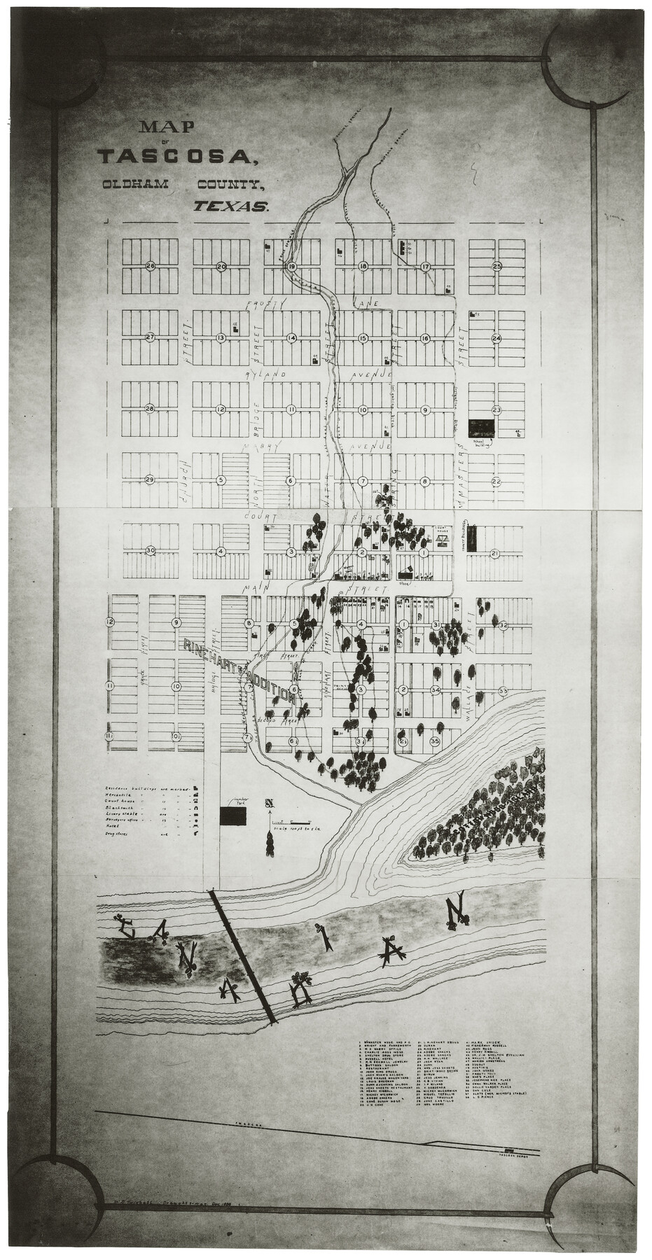
Map of Tascosa, Oldham County, Texas
-
Map/Doc
83011
-
Collection
General Map Collection
-
Object Dates
12/1886 (Creation Date)
-
People and Organizations
W.D. Twichell (Draftsman)
-
Counties
Oldham
-
Subjects
City
-
Height x Width
28.2 x 14.6 inches
71.6 x 37.1 cm
-
Scale
1" = 100'
-
Features
Tascosa
Boiling Spring
Buffalo Spring
Rock Springs
Tascosa Creek
Rhinehart's Addition
Cottonwood Island
Canadian River
Tascosa Depot
FW&DC
Part of: General Map Collection
Current Miscellaneous File 49

Print $4.00
- Digital $50.00
Current Miscellaneous File 49
Size 11.2 x 8.8 inches
Map/Doc 74012
Rockwall County Boundary File 52a

Print $22.00
- Digital $50.00
Rockwall County Boundary File 52a
Size 12.9 x 8.3 inches
Map/Doc 58461

Upton County Rolled Sketch 57

Print $20.00
- Digital $50.00
Upton County Rolled Sketch 57
Size 30.1 x 41.8 inches
Map/Doc 8090
Flight Mission No. DIX-8P, Frame 90, Aransas County

Print $20.00
- Digital $50.00
Flight Mission No. DIX-8P, Frame 90, Aransas County
1956
Size 18.6 x 22.4 inches
Map/Doc 83915
Lamb County Sketch File 11

Print $6.00
- Digital $50.00
Lamb County Sketch File 11
1913
Size 11.5 x 8.8 inches
Map/Doc 29360
Crosby County Working Sketch 10

Print $20.00
- Digital $50.00
Crosby County Working Sketch 10
1946
Size 44.5 x 23.7 inches
Map/Doc 68444
Castro County Sketch File 4m

Print $4.00
- Digital $50.00
Castro County Sketch File 4m
Size 13.6 x 8.6 inches
Map/Doc 17489
Pecos County Working Sketch 60

Print $20.00
- Digital $50.00
Pecos County Working Sketch 60
1950
Size 37.0 x 29.5 inches
Map/Doc 71532
Hemphill County Rolled Sketch 18

Print $20.00
- Digital $50.00
Hemphill County Rolled Sketch 18
Size 23.6 x 35.0 inches
Map/Doc 6200
Dimmit County Working Sketch 34

Print $20.00
- Digital $50.00
Dimmit County Working Sketch 34
1959
Size 22.8 x 17.0 inches
Map/Doc 68695
Flight Mission No. CGI-3N, Frame 130, Cameron County

Print $20.00
- Digital $50.00
Flight Mission No. CGI-3N, Frame 130, Cameron County
1954
Size 18.5 x 22.2 inches
Map/Doc 84603
You may also like
Gulf Oil Corp. Fishgide - Freeport

Gulf Oil Corp. Fishgide - Freeport
1960
Size 12.3 x 22.4 inches
Map/Doc 75978
Resurvey of the Original Townsite of Sundown Hockley County, Texas

Print $20.00
- Digital $50.00
Resurvey of the Original Townsite of Sundown Hockley County, Texas
Size 21.7 x 40.3 inches
Map/Doc 92234
Castro County Sketch File 18

Print $20.00
- Digital $50.00
Castro County Sketch File 18
1988
Size 40.4 x 37.7 inches
Map/Doc 10330
EL&RR S2, HE&WT K3, Pt.L&SV K, C4 & C3

Print $20.00
- Digital $50.00
EL&RR S2, HE&WT K3, Pt.L&SV K, C4 & C3
Size 23.3 x 17.5 inches
Map/Doc 90416
Reeves County Working Sketch 24

Print $40.00
- Digital $50.00
Reeves County Working Sketch 24
1966
Size 38.7 x 76.5 inches
Map/Doc 63467
Flight Mission No. DQN-2K, Frame 120, Calhoun County

Print $20.00
- Digital $50.00
Flight Mission No. DQN-2K, Frame 120, Calhoun County
1953
Size 18.4 x 16.1 inches
Map/Doc 84296
Anderson County Sketch File 3

Print $4.00
- Digital $50.00
Anderson County Sketch File 3
1856
Size 12.7 x 8.2 inches
Map/Doc 12741
Current Miscellaneous File 24a

Print $8.00
- Digital $50.00
Current Miscellaneous File 24a
1949
Size 11.0 x 8.6 inches
Map/Doc 73893
Copy of sketch in Nacogdoches Donation 724 on file in GLO

Print $20.00
- Digital $50.00
Copy of sketch in Nacogdoches Donation 724 on file in GLO
1890
Size 18.0 x 10.9 inches
Map/Doc 75803
Williamson County

Print $40.00
- Digital $50.00
Williamson County
1946
Size 37.3 x 54.8 inches
Map/Doc 77460
Flight Mission No. BQR-3K, Frame 83, Brazoria County

Print $20.00
- Digital $50.00
Flight Mission No. BQR-3K, Frame 83, Brazoria County
1952
Size 18.7 x 22.4 inches
Map/Doc 83975
Concho County Rolled Sketch 4

Print $20.00
- Digital $50.00
Concho County Rolled Sketch 4
1948
Size 47.3 x 43.6 inches
Map/Doc 8649