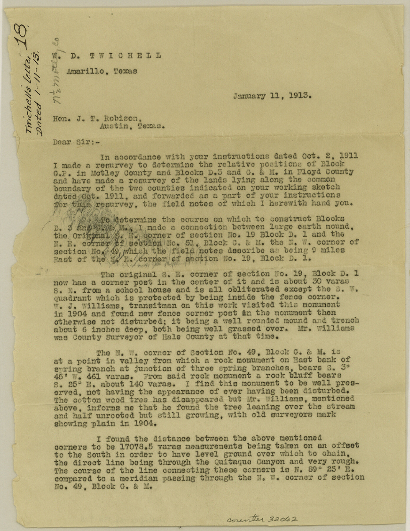
Motley County Sketch File 18 (N)
[Letter regarding Blocks GP, D3, and GM]
-
Map/Doc
32062
-
Collection
General Map Collection
-
Object Dates
1/11/1913 (Creation Date)
1/11/1913 (Correspondence Date)
1911 (Survey Date)
1904 (Survey Date)
-
People and Organizations
W.D. Twichell (Surveyor/Engineer)
W.J. Williams (Surveyor/Engineer)
W.J. Williams (Chainman/Field Personnel)
-
Counties
Motley Floyd
-
Subjects
Surveying Sketch File
-
Height x Width
11.3 x 8.7 inches
28.7 x 22.1 cm
-
Medium
paper, print
Part of: General Map Collection
Bexar County Working Sketch 9

Print $20.00
- Digital $50.00
Bexar County Working Sketch 9
1956
Size 23.4 x 21.6 inches
Map/Doc 67325
King County Sketch File 9

Print $20.00
- Digital $50.00
King County Sketch File 9
Size 23.5 x 33.0 inches
Map/Doc 11937
Map of Ramsey State Farm

Print $20.00
- Digital $50.00
Map of Ramsey State Farm
1934
Size 30.3 x 38.0 inches
Map/Doc 94284
Fisher County Sketch File 22

Print $12.00
- Digital $50.00
Fisher County Sketch File 22
Size 11.4 x 8.8 inches
Map/Doc 22651
Flight Mission No. DAH-17M, Frame 22, Orange County

Print $20.00
- Digital $50.00
Flight Mission No. DAH-17M, Frame 22, Orange County
1953
Size 18.8 x 22.6 inches
Map/Doc 86885
Roberts County

Print $20.00
- Digital $50.00
Roberts County
1889
Size 20.8 x 19.8 inches
Map/Doc 3993
Freestone County

Print $40.00
- Digital $50.00
Freestone County
1918
Size 49.0 x 41.0 inches
Map/Doc 4951
Presidio County Working Sketch 115

Print $20.00
- Digital $50.00
Presidio County Working Sketch 115
1981
Size 28.7 x 26.7 inches
Map/Doc 71792
Gonzales County

Print $40.00
- Digital $50.00
Gonzales County
1920
Size 41.0 x 51.2 inches
Map/Doc 1841
Map of Mason County

Print $20.00
- Digital $50.00
Map of Mason County
1879
Size 22.5 x 18.8 inches
Map/Doc 3839
Comanche County Sketch File 7

Print $6.00
- Digital $50.00
Comanche County Sketch File 7
1852
Size 9.9 x 8.1 inches
Map/Doc 19063
Map of Leon County

Print $40.00
- Digital $50.00
Map of Leon County
Size 49.7 x 42.0 inches
Map/Doc 66900
You may also like
Van Zandt County Rolled Sketch 6

Print $6.00
- Digital $50.00
Van Zandt County Rolled Sketch 6
1946
Size 33.5 x 34.2 inches
Map/Doc 10091
Bastrop County Boundary File 3

Print $48.00
- Digital $50.00
Bastrop County Boundary File 3
1925
Size 11.3 x 8.7 inches
Map/Doc 50320
Val Verde County Sketch File Z15

Print $22.00
- Digital $50.00
Val Verde County Sketch File Z15
1902
Size 15.2 x 17.2 inches
Map/Doc 39144
Eastland County Working Sketch 41

Print $20.00
- Digital $50.00
Eastland County Working Sketch 41
1975
Size 37.3 x 34.7 inches
Map/Doc 68822
[Blocks DD, C33, C32, C31, C36, C37, C38, C39, C41, C40, T]
![92935, [Blocks DD, C33, C32, C31, C36, C37, C38, C39, C41, C40, T], Twichell Survey Records](https://historictexasmaps.com/wmedia_w700/maps/92935-1.tif.jpg)
Print $20.00
- Digital $50.00
[Blocks DD, C33, C32, C31, C36, C37, C38, C39, C41, C40, T]
Size 44.0 x 24.8 inches
Map/Doc 92935
Travis County Rolled Sketch 54

Print $20.00
- Digital $50.00
Travis County Rolled Sketch 54
Size 25.2 x 36.7 inches
Map/Doc 8046
Flight Mission No. BRA-16M, Frame 50, Jefferson County

Print $20.00
- Digital $50.00
Flight Mission No. BRA-16M, Frame 50, Jefferson County
1953
Size 18.5 x 22.5 inches
Map/Doc 85667
Galveston County NRC Article 33.136 Sketch 55B

Print $24.00
- Digital $50.00
Galveston County NRC Article 33.136 Sketch 55B
2007
Size 24.0 x 36.0 inches
Map/Doc 94666
Motley County Boundary File 1a

Print $8.00
- Digital $50.00
Motley County Boundary File 1a
Size 11.2 x 8.5 inches
Map/Doc 57501
Flight Mission No. CRC-6R, Frame 36, Chambers County

Print $20.00
- Digital $50.00
Flight Mission No. CRC-6R, Frame 36, Chambers County
1956
Size 18.8 x 22.4 inches
Map/Doc 84969
Hunt County Sketch File 49

Print $4.00
- Digital $50.00
Hunt County Sketch File 49
1852
Size 7.3 x 8.9 inches
Map/Doc 27168
[Index map of T. & P. Ry. Company’s 80-mile Trans-Pecos Reserve’s perpetuated corners - North Part]
![89622, [Index map of T. & P. Ry. Company’s 80-mile Trans-Pecos Reserve’s perpetuated corners - North Part], General Map Collection](https://historictexasmaps.com/wmedia_w700/maps/89622-1.tif.jpg)
Print $40.00
- Digital $50.00
[Index map of T. & P. Ry. Company’s 80-mile Trans-Pecos Reserve’s perpetuated corners - North Part]
Size 25.4 x 92.1 inches
Map/Doc 89622