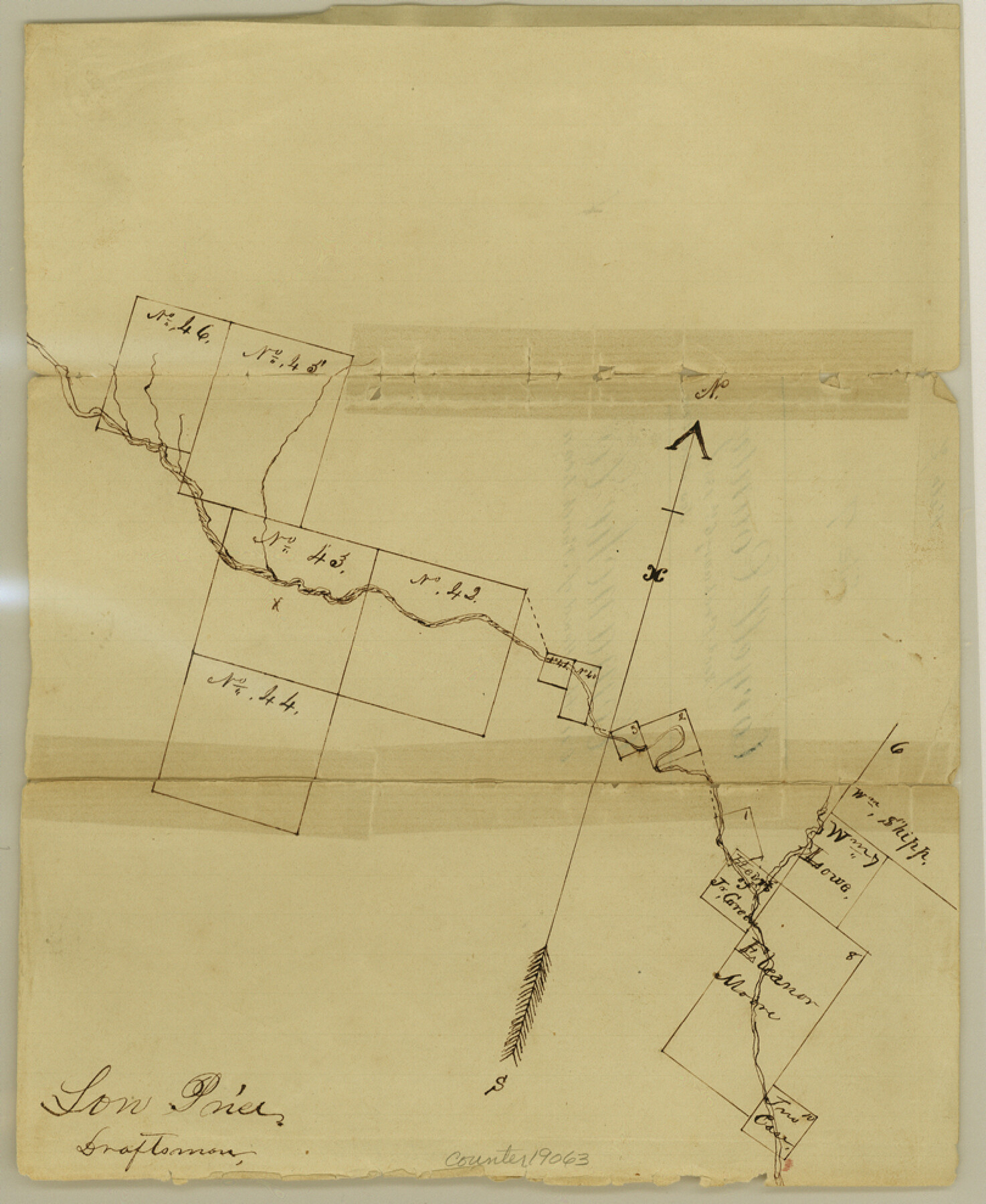
Comanche County Sketch File 7
[Sketch of surveys at head of North Leon River]
-
Map/Doc
19063
-
Collection
General Map Collection
-
Object Dates
1852/2/6 (Creation Date)
-
People and Organizations
Lon Price (Surveyor/Engineer)
Lon Price (Draftsman)
-
Counties
Comanche
-
Subjects
Surveying Sketch File
-
Height x Width
9.9 x 8.1 inches
25.1 x 20.6 cm
-
Medium
paper, manuscript
-
Features
[North Leon River]
Part of: General Map Collection
Starr County Rolled Sketch 2

Print $40.00
- Digital $50.00
Starr County Rolled Sketch 2
1853
Size 31.7 x 48.5 inches
Map/Doc 9938
Map of Live Oak County

Print $20.00
- Digital $50.00
Map of Live Oak County
1878
Size 27.4 x 20.8 inches
Map/Doc 3823
Clay County Sketch File 21

Print $2.00
- Digital $50.00
Clay County Sketch File 21
1882
Size 11.3 x 8.7 inches
Map/Doc 18435
Reagan County Rolled Sketch 36

Print $20.00
- Digital $50.00
Reagan County Rolled Sketch 36
1960
Size 31.0 x 13.4 inches
Map/Doc 7449
Flight Mission No. BRE-2P, Frame 134, Nueces County

Print $20.00
- Digital $50.00
Flight Mission No. BRE-2P, Frame 134, Nueces County
1956
Size 18.4 x 22.3 inches
Map/Doc 86807
San Luis Pass to East Matagorda Bay

Print $20.00
- Digital $50.00
San Luis Pass to East Matagorda Bay
1957
Size 34.9 x 46.9 inches
Map/Doc 69962
Township 11 North Range 16 West, South Western District, Louisiana

Print $20.00
- Digital $50.00
Township 11 North Range 16 West, South Western District, Louisiana
1834
Size 19.7 x 24.7 inches
Map/Doc 65869
Kendall County Working Sketch 15

Print $20.00
- Digital $50.00
Kendall County Working Sketch 15
1967
Size 41.4 x 40.7 inches
Map/Doc 66687
[Surveys in Milam District between the Bosque and Brazos Rivers]
![3, [Surveys in Milam District between the Bosque and Brazos Rivers], General Map Collection](https://historictexasmaps.com/wmedia_w700/maps/3.tif.jpg)
Print $20.00
- Digital $50.00
[Surveys in Milam District between the Bosque and Brazos Rivers]
1847
Size 15.8 x 12.2 inches
Map/Doc 3
San Patricio County Rolled Sketch 31

Print $20.00
- Digital $50.00
San Patricio County Rolled Sketch 31
1941
Size 43.1 x 42.6 inches
Map/Doc 9898
Crockett County Rolled Sketch 29

Print $20.00
- Digital $50.00
Crockett County Rolled Sketch 29
1927
Size 21.9 x 36.6 inches
Map/Doc 5588
Sabine County

Print $20.00
- Digital $50.00
Sabine County
1920
Size 43.9 x 34.6 inches
Map/Doc 63014
You may also like
Flight Mission No. CGI-1N, Frame 168, Cameron County

Print $20.00
- Digital $50.00
Flight Mission No. CGI-1N, Frame 168, Cameron County
1955
Size 18.5 x 22.2 inches
Map/Doc 84503
[Surveys along Bosque and Hog Creek]
![238, [Surveys along Bosque and Hog Creek], General Map Collection](https://historictexasmaps.com/wmedia_w700/maps/238.tif.jpg)
Print $20.00
- Digital $50.00
[Surveys along Bosque and Hog Creek]
1845
Size 23.9 x 17.0 inches
Map/Doc 238
Reagan County Working Sketch 17

Print $20.00
- Digital $50.00
Reagan County Working Sketch 17
1954
Size 21.0 x 11.7 inches
Map/Doc 71859
Harris County Working Sketch 106

Print $40.00
- Digital $50.00
Harris County Working Sketch 106
1981
Size 48.0 x 25.0 inches
Map/Doc 65998
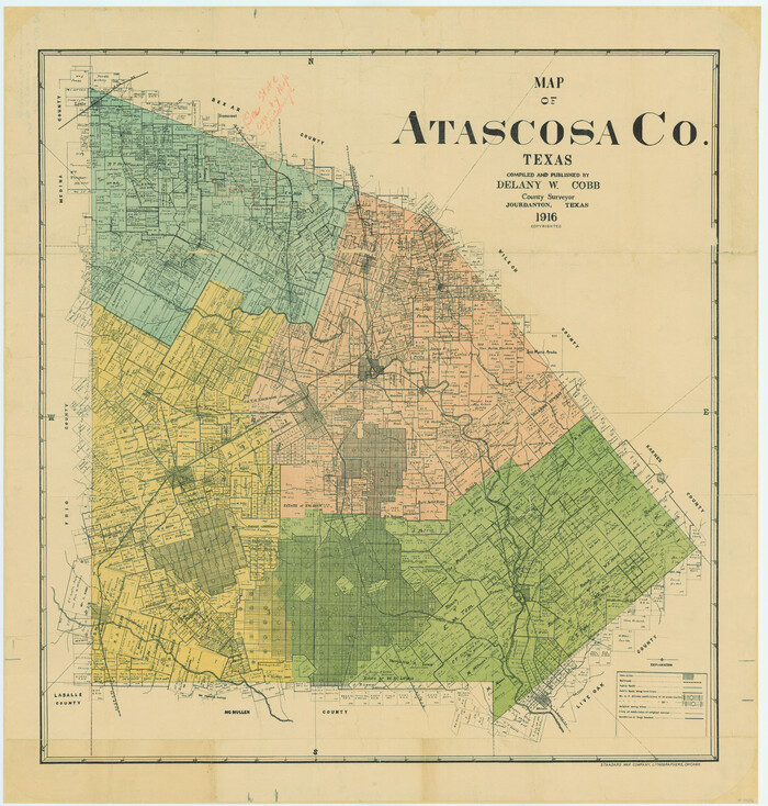
Map of Atascosa County, Texas
Print $20.00
- Digital $50.00
Map of Atascosa County, Texas
1916
Size 30.0 x 28.6 inches
Map/Doc 9006
Tom Green County Sketch File 62

Print $20.00
- Digital $50.00
Tom Green County Sketch File 62
1890
Size 27.7 x 43.9 inches
Map/Doc 10405
Map Showing Resurvey of Capitol Leagues, Lamb, Cochran & Hockley Co's.

Print $20.00
- Digital $50.00
Map Showing Resurvey of Capitol Leagues, Lamb, Cochran & Hockley Co's.
1918
Size 37.0 x 29.3 inches
Map/Doc 1759
Edwards County Rolled Sketch 15

Print $20.00
- Digital $50.00
Edwards County Rolled Sketch 15
1893
Size 35.5 x 26.4 inches
Map/Doc 5803
Edwards County Rolled Sketch 31

Print $20.00
- Digital $50.00
Edwards County Rolled Sketch 31
1982
Size 30.5 x 39.4 inches
Map/Doc 8849
![89869, [Morton], Twichell Survey Records](https://historictexasmaps.com/wmedia_w700/maps/89869-1.tif.jpg)
Liberty County Rolled Sketch 15

Print $20.00
- Digital $50.00
Liberty County Rolled Sketch 15
2015
Size 36.1 x 24.3 inches
Map/Doc 94022
Presidio County Rolled Sketch 131A

Print $20.00
- Digital $50.00
Presidio County Rolled Sketch 131A
Size 17.7 x 11.9 inches
Map/Doc 10710