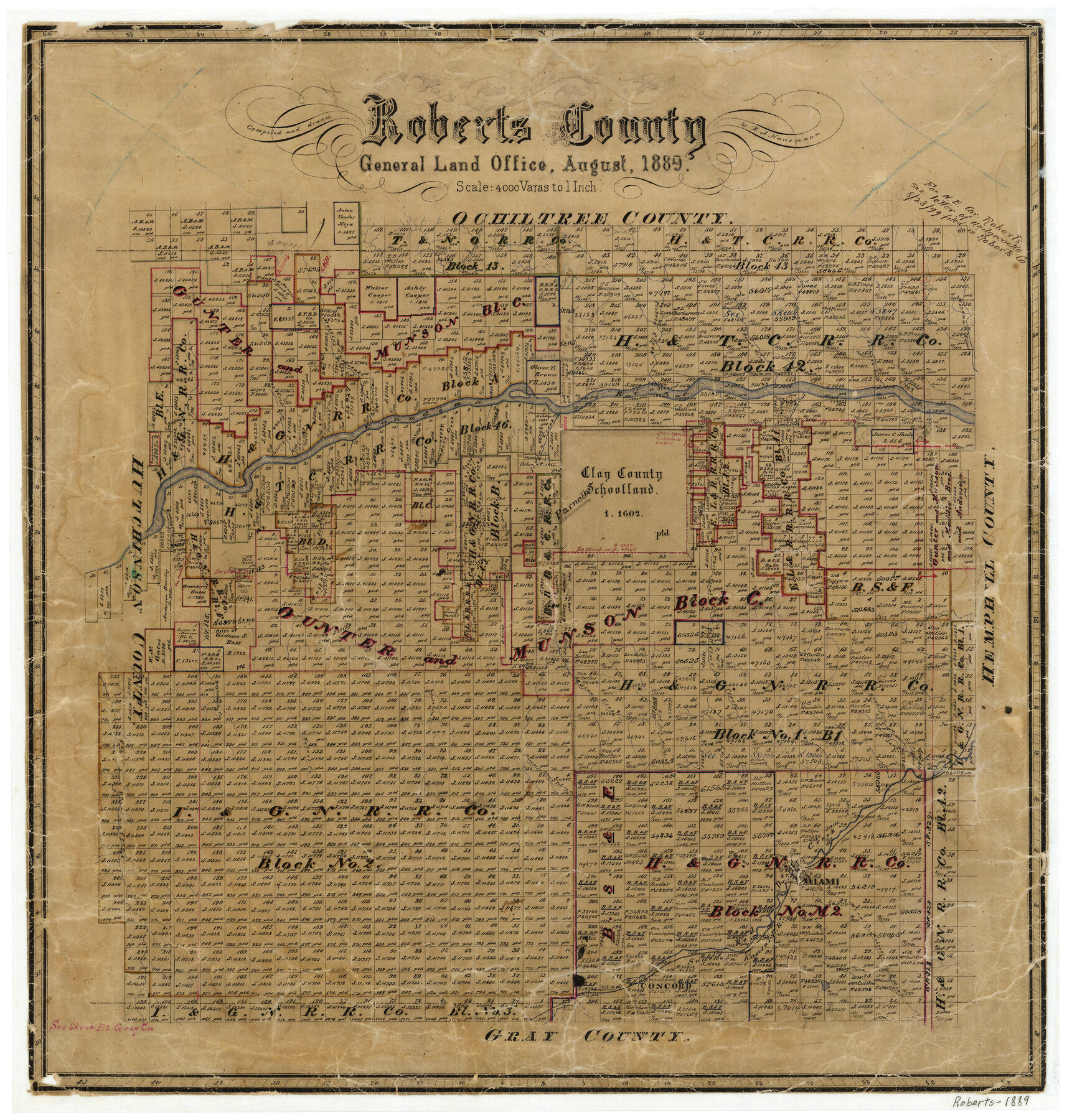
Roberts County
-
Map/Doc
3993
-
Collection
General Map Collection
-
Object Dates
8/1889 (Creation Date)
-
People and Organizations
Texas General Land Office (Publisher)
E.A. Hausmann (Compiler)
E.A. Hausmann (Draftsman)
-
Counties
Roberts
-
Subjects
County
-
Height x Width
20.8 x 19.8 inches
52.8 x 50.3 cm
-
Features
St. Clair Creek
Miami to Mobeetie Road
Chicken Creek
Houston Road
Parnell
Concord
Miami Road
Mobeetie Road
SKR
White Deer Creek
Miami
Red Deer Creek
Bone Pile Prong of Indian Creek
Walnut Creek
Reynold's Creek
Palahotta Creek
Sourdough Creek
Three Coral Creek
Tallahan Creek
Timber Creek
Runnel's Creek
Home Ranch Creek
Barkon Creek
Pickett Creek
Indian Creek
Sander's Creek
Canadian River
Walker Creek
Martin's Creek
Point Creek
Hackberry Creek
Morgan Creek
Part of: General Map Collection
Trinity River, Wire Bridge Sheet/Denton Creek

Print $6.00
- Digital $50.00
Trinity River, Wire Bridge Sheet/Denton Creek
1938
Size 30.4 x 29.7 inches
Map/Doc 65244
Gaines County

Print $40.00
- Digital $50.00
Gaines County
1902
Size 41.8 x 57.2 inches
Map/Doc 16831
Ellis County Boundary File 3

Print $58.00
- Digital $50.00
Ellis County Boundary File 3
Size 14.1 x 122.4 inches
Map/Doc 52950
Intracoastal Waterway in Texas - Corpus Christi to Point Isabel including Arroyo Colorado to Mo. Pac. R.R. Bridge Near Harlingen

Print $20.00
- Digital $50.00
Intracoastal Waterway in Texas - Corpus Christi to Point Isabel including Arroyo Colorado to Mo. Pac. R.R. Bridge Near Harlingen
1934
Size 22.0 x 32.7 inches
Map/Doc 61884
Duval County Working Sketch 47

Print $20.00
- Digital $50.00
Duval County Working Sketch 47
1981
Size 20.8 x 30.9 inches
Map/Doc 68771
Webb County Working Sketch 20

Print $20.00
- Digital $50.00
Webb County Working Sketch 20
1925
Size 22.3 x 20.2 inches
Map/Doc 72385
Webb County Working Sketch 23

Print $20.00
- Digital $50.00
Webb County Working Sketch 23
1927
Size 15.1 x 17.3 inches
Map/Doc 72388
Flight Mission No. CRK-5P, Frame 124, Refugio County

Print $20.00
- Digital $50.00
Flight Mission No. CRK-5P, Frame 124, Refugio County
1956
Size 18.7 x 22.5 inches
Map/Doc 86927
Dickens County Sketch File H

Print $28.00
- Digital $50.00
Dickens County Sketch File H
Size 13.2 x 8.9 inches
Map/Doc 20861
Colorado County Sketch File 14

Print $8.00
- Digital $50.00
Colorado County Sketch File 14
1874
Size 12.8 x 8.0 inches
Map/Doc 18939
Map of Caldwell County, Land District since August 1st. 1859; Originally the part north, east of the line designated Bastrop - the balance, Gonzales Land District

Print $20.00
- Digital $50.00
Map of Caldwell County, Land District since August 1st. 1859; Originally the part north, east of the line designated Bastrop - the balance, Gonzales Land District
1861
Size 19.9 x 23.0 inches
Map/Doc 3355
Dimmit County Working Sketch 35

Print $20.00
- Digital $50.00
Dimmit County Working Sketch 35
1961
Size 22.4 x 24.4 inches
Map/Doc 68696
You may also like
Archer County Sketch File 18

Print $40.00
- Digital $50.00
Archer County Sketch File 18
Size 23.9 x 13.0 inches
Map/Doc 10828
[Sketch Showing Wm. T. Brewer, John R. Taylor, Wm. F. Butler, Timothy DeVore, L. M. Thorn and adjoining surveys]
![90209, [Sketch Showing Wm. T. Brewer, John R. Taylor, Wm. F. Butler, Timothy DeVore, L. M. Thorn and adjoining surveys], Twichell Survey Records](https://historictexasmaps.com/wmedia_w700/maps/90209-1.tif.jpg)
Print $20.00
- Digital $50.00
[Sketch Showing Wm. T. Brewer, John R. Taylor, Wm. F. Butler, Timothy DeVore, L. M. Thorn and adjoining surveys]
Size 20.2 x 36.6 inches
Map/Doc 90209
Crosby County Boundary File 2

Print $64.00
- Digital $50.00
Crosby County Boundary File 2
Size 42.8 x 7.0 inches
Map/Doc 51997
Limestone County Working Sketch 22

Print $40.00
- Digital $50.00
Limestone County Working Sketch 22
1980
Size 43.3 x 60.2 inches
Map/Doc 70572
Nueces County Sketch File 81

Print $20.00
- Digital $50.00
Nueces County Sketch File 81
Size 11.2 x 8.7 inches
Map/Doc 33155
Gaines County Rolled Sketch 17

Print $20.00
- Digital $50.00
Gaines County Rolled Sketch 17
1940
Size 24.5 x 17.8 inches
Map/Doc 5934
Uvalde County Rolled Sketch 24

Print $20.00
- Digital $50.00
Uvalde County Rolled Sketch 24
2014
Size 16.2 x 16.1 inches
Map/Doc 93722
[West half of County]
![89961, [West half of County], Twichell Survey Records](https://historictexasmaps.com/wmedia_w700/maps/89961-1.tif.jpg)
Print $40.00
- Digital $50.00
[West half of County]
1914
Size 40.0 x 62.5 inches
Map/Doc 89961
[Surveys along the Trinity River]
![330, [Surveys along the Trinity River], General Map Collection](https://historictexasmaps.com/wmedia_w700/maps/330.tif.jpg)
Print $2.00
- Digital $50.00
[Surveys along the Trinity River]
1846
Size 9.0 x 12.2 inches
Map/Doc 330
Upton County Rolled Sketch 34

Print $20.00
- Digital $50.00
Upton County Rolled Sketch 34
1951
Size 34.4 x 34.3 inches
Map/Doc 10050
Lipscomb County Rolled Sketch 5

Print $40.00
- Digital $50.00
Lipscomb County Rolled Sketch 5
Size 61.8 x 8.1 inches
Map/Doc 10640
Right of Way and Track Map - Houston & Texas Central R.R. operated by the T. and N. O. R.R. Co. - Main Line

Print $40.00
- Digital $50.00
Right of Way and Track Map - Houston & Texas Central R.R. operated by the T. and N. O. R.R. Co. - Main Line
1918
Size 25.2 x 57.8 inches
Map/Doc 82859