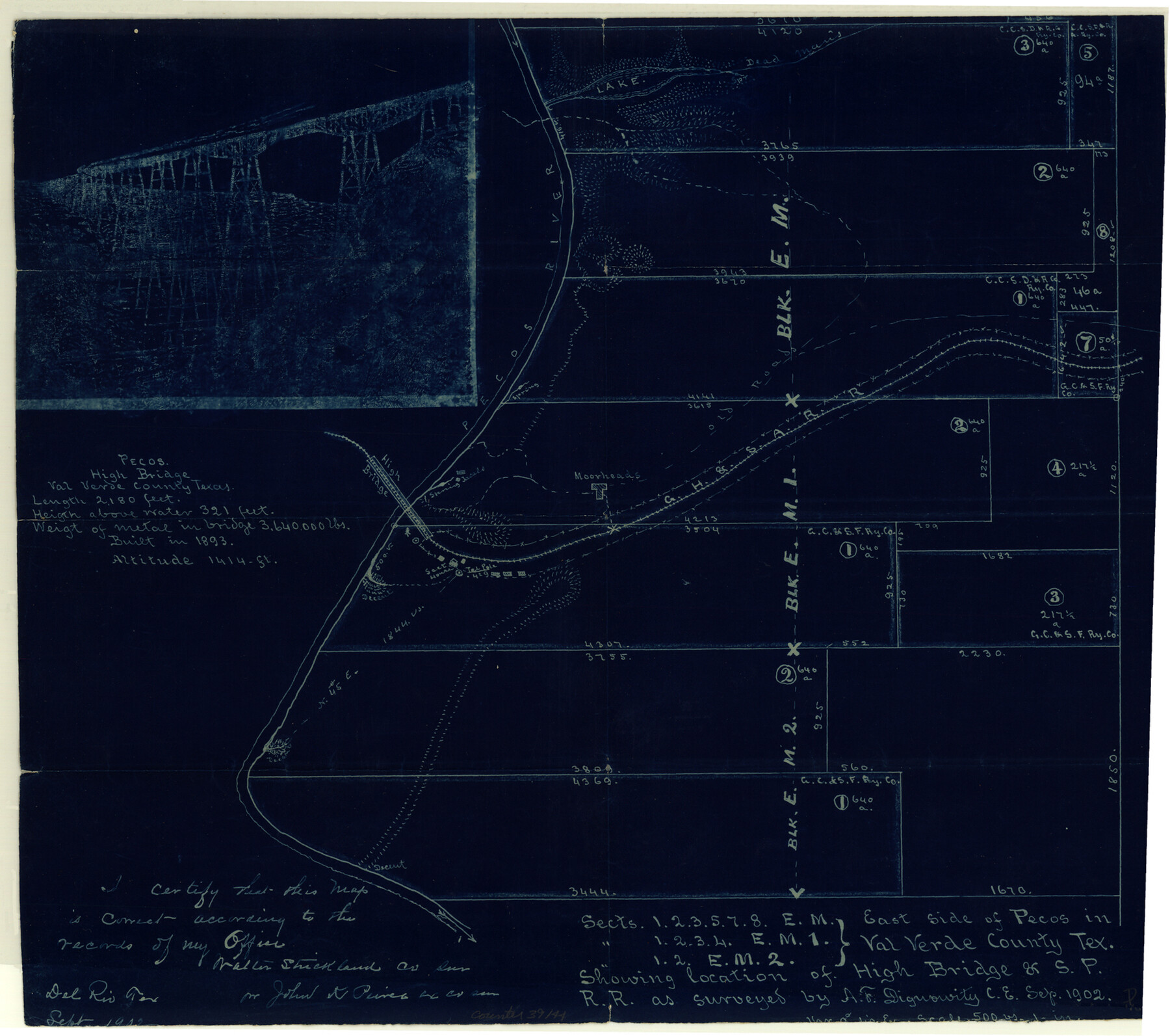
Val Verde County Sketch File Z15
[Sketch of surveys on east side of Pecos River in the vicinity of "High Bridge" of S. P. R.R. Co.]
-
Map/Doc
39144
-
Collection
General Map Collection
-
Object Dates
9/1902 (Creation Date)
1/24/1902 (File Date)
-
People and Organizations
Walter Strickland (Surveyor/Engineer)
-
Counties
Val Verde
-
Subjects
Surveying Sketch File
-
Height x Width
15.2 x 17.2 inches
38.6 x 43.7 cm
-
Medium
blueprint/diazo
-
Features
Dead Man's [Creek]
Pecos River
High Bridge
Sect House
GH&SA
Part of: General Map Collection
Coleman County Rolled Sketch 6

Print $20.00
- Digital $50.00
Coleman County Rolled Sketch 6
Size 20.9 x 14.4 inches
Map/Doc 5529
Marion County Working Sketch 5

Print $20.00
- Digital $50.00
Marion County Working Sketch 5
1910
Size 24.5 x 15.2 inches
Map/Doc 70780
Hartley County Boundary File 3

Print $15.00
- Digital $50.00
Hartley County Boundary File 3
Size 6.7 x 16.5 inches
Map/Doc 54476
Palo Pinto County Sketch File 4

Print $4.00
- Digital $50.00
Palo Pinto County Sketch File 4
1870
Size 8.2 x 12.9 inches
Map/Doc 33394
San Saba County Working Sketch Graphic Index

Print $20.00
- Digital $50.00
San Saba County Working Sketch Graphic Index
1918
Size 46.5 x 41.1 inches
Map/Doc 76693
Val Verde County Sketch File Z7

Print $20.00
- Digital $50.00
Val Verde County Sketch File Z7
Size 25.6 x 17.2 inches
Map/Doc 12552
Shackelford County Working Sketch 10

Print $20.00
- Digital $50.00
Shackelford County Working Sketch 10
1984
Size 28.8 x 26.1 inches
Map/Doc 63850
Right of Way and Track Map San Antonio and Aransas Pass Railway Co.

Print $4.00
- Digital $50.00
Right of Way and Track Map San Antonio and Aransas Pass Railway Co.
1919
Size 11.9 x 18.5 inches
Map/Doc 62562
Terrell County Working Sketch 71

Print $20.00
- Digital $50.00
Terrell County Working Sketch 71
1980
Size 22.5 x 30.8 inches
Map/Doc 69592
Dimmit County Sketch File 25

Print $4.00
- Digital $50.00
Dimmit County Sketch File 25
1885
Size 12.9 x 8.6 inches
Map/Doc 21142
Tyler County Sketch File 13

Print $6.00
- Digital $50.00
Tyler County Sketch File 13
1857
Size 8.7 x 13.0 inches
Map/Doc 38653
Right of Way and Track Map of The Wichita Falls & Southern Railroad Company

Print $40.00
- Digital $50.00
Right of Way and Track Map of The Wichita Falls & Southern Railroad Company
1942
Size 24.6 x 56.1 inches
Map/Doc 64518
You may also like
Hunt County Sketch File 11

Print $4.00
- Digital $50.00
Hunt County Sketch File 11
1860
Size 12.1 x 7.6 inches
Map/Doc 27102
[Sketch for Mineral Application 33721 - 33725 Incl. - Padre and Mustang Island]
![2868, [Sketch for Mineral Application 33721 - 33725 Incl. - Padre and Mustang Island], General Map Collection](https://historictexasmaps.com/wmedia_w700/maps/2868.tif.jpg)
Print $20.00
- Digital $50.00
[Sketch for Mineral Application 33721 - 33725 Incl. - Padre and Mustang Island]
1942
Size 29.7 x 22.3 inches
Map/Doc 2868
Map of Texas-Mexican Railway Lands in El Paso County, Texas

Print $3.00
- Digital $50.00
Map of Texas-Mexican Railway Lands in El Paso County, Texas
1907
Size 13.7 x 10.8 inches
Map/Doc 91134
Schleicher County Rolled Sketch 25

Print $20.00
- Digital $50.00
Schleicher County Rolled Sketch 25
1969
Size 32.3 x 37.9 inches
Map/Doc 9908
Map of Town Tract of Refugio

Print $20.00
- Digital $50.00
Map of Town Tract of Refugio
1879
Size 25.4 x 24.5 inches
Map/Doc 4829
West Half Section 4, Block C-33, Gaines County, Texas

Print $20.00
- Digital $50.00
West Half Section 4, Block C-33, Gaines County, Texas
1953
Size 12.9 x 23.7 inches
Map/Doc 92667
Briscoe County

Print $20.00
- Digital $50.00
Briscoe County
1930
Size 46.2 x 39.2 inches
Map/Doc 1787
[Marion County School Land, Jack County School Land, Abel A. Lewis and other surveys in vicinity]
![90427, [Marion County School Land, Jack County School Land, Abel A. Lewis and other surveys in vicinity], Twichell Survey Records](https://historictexasmaps.com/wmedia_w700/maps/90427-1.tif.jpg)
Print $20.00
- Digital $50.00
[Marion County School Land, Jack County School Land, Abel A. Lewis and other surveys in vicinity]
Size 22.0 x 25.1 inches
Map/Doc 90427
Montgomery County Texas Historical Map

Montgomery County Texas Historical Map
Size 23.2 x 35.3 inches
Map/Doc 94404
Map of Young County

Print $20.00
- Digital $50.00
Map of Young County
Size 16.9 x 19.7 inches
Map/Doc 92108
Carta Esférica del Seno Mexicano y Canales Viexo y de Bama

Carta Esférica del Seno Mexicano y Canales Viexo y de Bama
1797
Size 26.7 x 47.1 inches
Map/Doc 94569
Official Map of the Highway System of Texas

Print $20.00
Official Map of the Highway System of Texas
1933
Size 26.1 x 27.0 inches
Map/Doc 79308