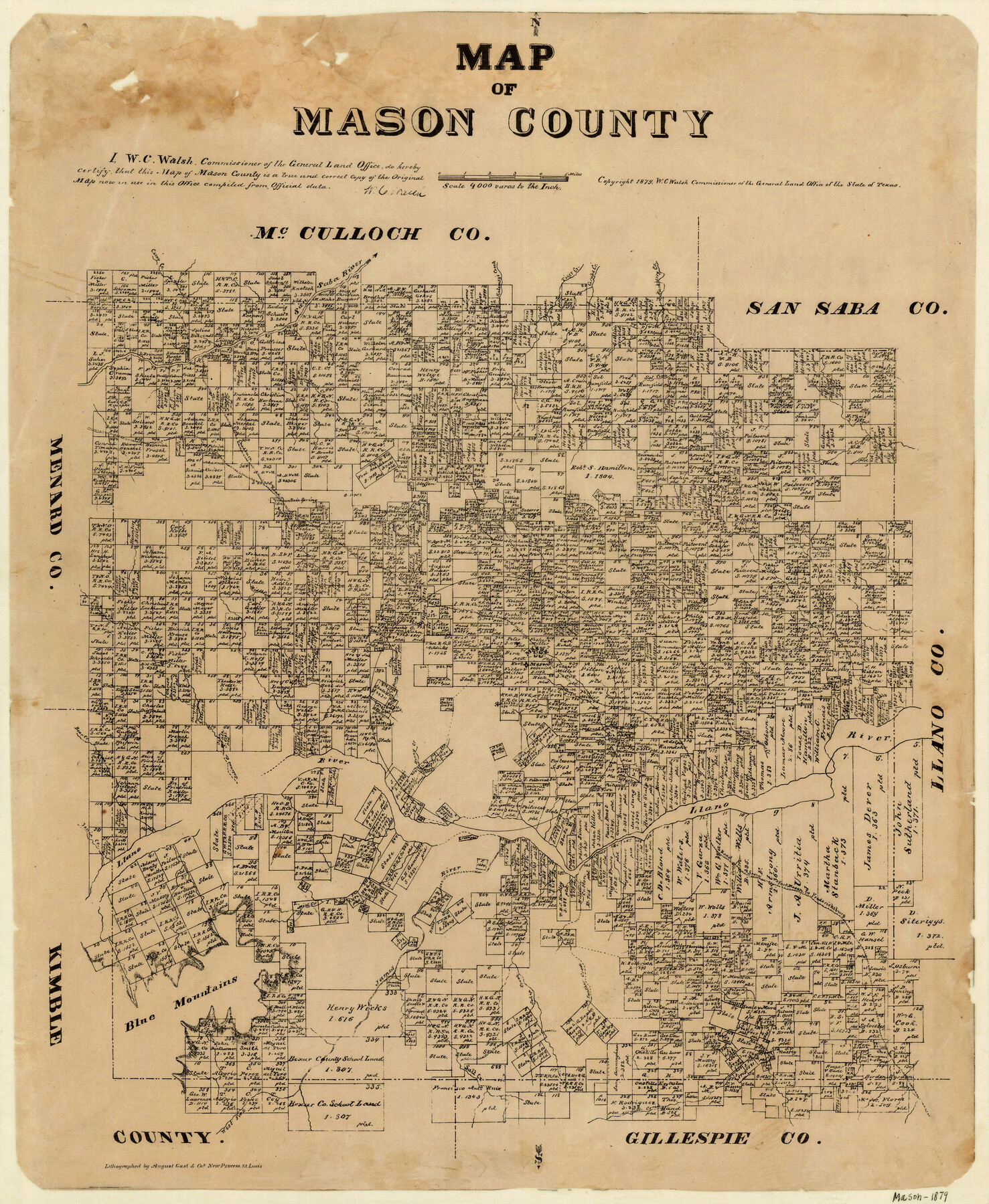
Map of Mason County
-
Map/Doc
3839
-
Collection
General Map Collection
-
Object Dates
1879 (Creation Date)
-
People and Organizations
W.C. Walsh (GLO Commissioner)
August Gast & Co. (Lithographer)
-
Counties
Mason
-
Subjects
County
-
Height x Width
22.5 x 18.8 inches
57.2 x 47.8 cm
-
Comments
Copyrighted 1879.
-
Features
Salinas Creek
Mountain Spring
Mesquite Creek
West Fork of James River
Salt Creek
Panther Creek
Schep Creek
Beaver Creek
Fredericksburg Road
Fort Mason Road
Road from Fort Mason to Fredericksburg
James River
Mill Creek
Blue Mountains
Ionia Creek
Bear Creek
Camp Creek
Willow Creek
Llano River
Fort Mason
Mason
Honey Creek
Middle Fork of Llano River
Iron Mound
Fort Chadburn [sic] Road
Hackberry Creek
Grape Creek
Tiger Creek
Kalemsy's Creek
Ranch Creek
San Saba River
Part of: General Map Collection
Kleberg County Rolled Sketch 10-35

Print $20.00
- Digital $50.00
Kleberg County Rolled Sketch 10-35
1952
Size 38.2 x 35.4 inches
Map/Doc 9366
Flight Mission No. BRA-3M, Frame 191, Jefferson County

Print $20.00
- Digital $50.00
Flight Mission No. BRA-3M, Frame 191, Jefferson County
1953
Size 18.6 x 22.3 inches
Map/Doc 85406
Montgomery County Rolled Sketch 27

Print $20.00
- Digital $50.00
Montgomery County Rolled Sketch 27
Size 34.5 x 34.4 inches
Map/Doc 9536
Orange County Working Sketch 48

Print $20.00
- Digital $50.00
Orange County Working Sketch 48
1991
Size 13.3 x 19.9 inches
Map/Doc 71380
San Augustine Co.

Print $20.00
- Digital $50.00
San Augustine Co.
1949
Size 45.7 x 28.6 inches
Map/Doc 77414
Johnson County Boundary File 51a

Print $66.00
- Digital $50.00
Johnson County Boundary File 51a
Size 12.7 x 8.2 inches
Map/Doc 55604
Pecos County Rolled Sketch 82

Print $20.00
- Digital $50.00
Pecos County Rolled Sketch 82
1930
Size 29.0 x 26.4 inches
Map/Doc 10192
Potter County Boundary File 2

Print $30.00
- Digital $50.00
Potter County Boundary File 2
Size 9.0 x 6.0 inches
Map/Doc 57952
Flight Mission No. CGI-3N, Frame 142, Cameron County

Print $20.00
- Digital $50.00
Flight Mission No. CGI-3N, Frame 142, Cameron County
1954
Size 18.7 x 22.3 inches
Map/Doc 84615
Map of Padre Island

Print $40.00
- Digital $50.00
Map of Padre Island
Size 74.6 x 22.8 inches
Map/Doc 76020
Gregg County Sketch File 11

Print $12.00
- Digital $50.00
Gregg County Sketch File 11
1933
Size 14.4 x 8.9 inches
Map/Doc 24591
San Patricio County Rolled Sketch 44

Print $55.00
- Digital $50.00
San Patricio County Rolled Sketch 44
1934
Size 9.8 x 14.9 inches
Map/Doc 48933
You may also like
Bell County Working Sketch 10

Print $20.00
- Digital $50.00
Bell County Working Sketch 10
1954
Size 38.2 x 41.4 inches
Map/Doc 67350
Nueces County Rolled Sketch 4

Print $20.00
- Digital $50.00
Nueces County Rolled Sketch 4
1910
Size 39.8 x 38.5 inches
Map/Doc 9583

A New and Correct County Map of the State of Texas

Print $20.00
- Digital $50.00
A New and Correct County Map of the State of Texas
1891
Size 22.4 x 27.3 inches
Map/Doc 95760
Map of Cameron County

Print $40.00
- Digital $50.00
Map of Cameron County
1895
Size 48.9 x 28.9 inches
Map/Doc 4901
Ward County Rolled Sketch 18

Print $20.00
- Digital $50.00
Ward County Rolled Sketch 18
1949
Size 31.6 x 34.0 inches
Map/Doc 10109
Burnet County Working Sketch 11

Print $20.00
- Digital $50.00
Burnet County Working Sketch 11
1975
Size 26.5 x 28.9 inches
Map/Doc 67854
Duval County Working Sketch 5
Print $40.00
- Digital $50.00
Duval County Working Sketch 5
1933
Size 43.2 x 54.2 inches
Map/Doc 68718
Presidio County Rolled Sketch 59

Print $20.00
- Digital $50.00
Presidio County Rolled Sketch 59
Size 27.6 x 18.2 inches
Map/Doc 7352
Gaines County Working Sketch 29

Print $20.00
- Digital $50.00
Gaines County Working Sketch 29
1984
Size 32.3 x 42.9 inches
Map/Doc 69329
Harrison County Working Sketch 31

Print $40.00
- Digital $50.00
Harrison County Working Sketch 31
2006
Size 48.0 x 50.2 inches
Map/Doc 87148
Bosque County Sketch File 26

Print $4.00
- Digital $50.00
Bosque County Sketch File 26
1868
Size 8.1 x 7.5 inches
Map/Doc 14811