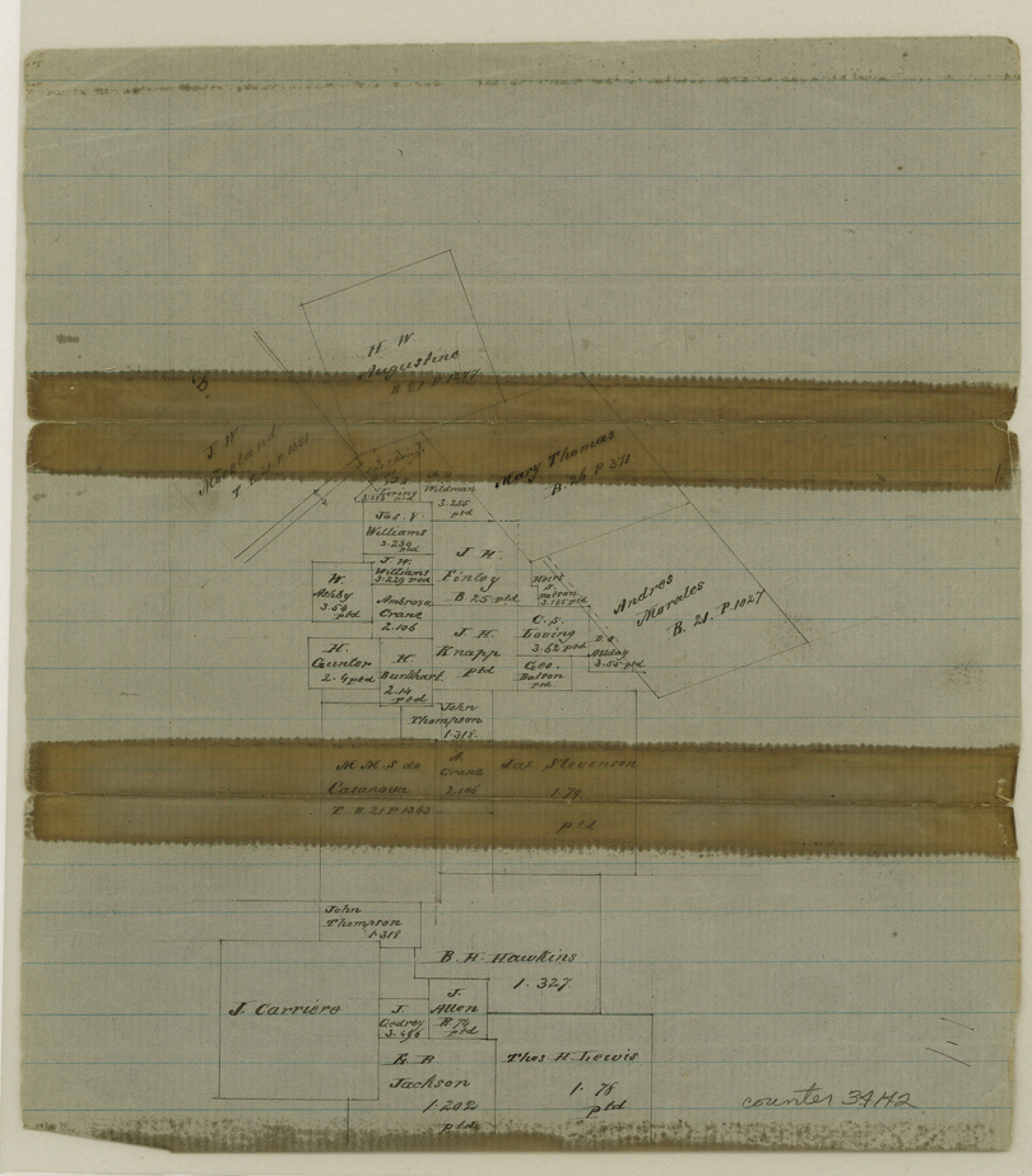
Polk County Sketch File 11
[Sketch of surveys in southeast part of county]
-
Map/Doc
34142
-
Collection
General Map Collection
-
Counties
Polk Hardin Liberty
-
Subjects
Surveying Sketch File
-
Height x Width
9.2 x 8.1 inches
23.4 x 20.6 cm
-
Medium
paper, manuscript
Part of: General Map Collection

Map of the River Sabine from its mouth on the Gulf of Mexico in the sea to Logan's Ferry in latitude 31° 58' 24" north

Print $20.00
- Digital $50.00
Map of the River Sabine from its mouth on the Gulf of Mexico in the sea to Logan's Ferry in latitude 31° 58' 24" north
1842
Size 18.5 x 9.0 inches
Map/Doc 65384
Galveston/Galveston Island, Texas

Galveston/Galveston Island, Texas
Size 18.4 x 24.2 inches
Map/Doc 94345
Hale County Working Sketch 5

Print $20.00
- Digital $50.00
Hale County Working Sketch 5
1980
Size 15.0 x 11.1 inches
Map/Doc 63325
Flight Mission No. CRC-3R, Frame 8, Chambers County

Print $20.00
- Digital $50.00
Flight Mission No. CRC-3R, Frame 8, Chambers County
1956
Size 18.6 x 22.2 inches
Map/Doc 84782
Van Zandt County Sketch File 24

Print $4.00
- Digital $50.00
Van Zandt County Sketch File 24
1858
Size 6.7 x 7.9 inches
Map/Doc 39439
Navasota River, Long Bridge Crossing Sheet

Print $20.00
- Digital $50.00
Navasota River, Long Bridge Crossing Sheet
1934
Size 43.1 x 36.6 inches
Map/Doc 65073
Map of Fisher and Miller's Colony made from the records in the Office of the District Surveyor of Bexar comprising also all the recent surveys

Print $20.00
- Digital $50.00
Map of Fisher and Miller's Colony made from the records in the Office of the District Surveyor of Bexar comprising also all the recent surveys
1855
Size 23.7 x 35.2 inches
Map/Doc 1971
Flight Mission No. DQO-8K, Frame 80, Galveston County

Print $20.00
- Digital $50.00
Flight Mission No. DQO-8K, Frame 80, Galveston County
1952
Size 18.8 x 22.5 inches
Map/Doc 85184
Jasper County

Print $40.00
- Digital $50.00
Jasper County
1946
Size 48.6 x 42.9 inches
Map/Doc 73192
Ward County Rolled Sketch 24B

Print $40.00
- Digital $50.00
Ward County Rolled Sketch 24B
1967
Size 24.7 x 56.4 inches
Map/Doc 10115
Hill County Boundary File 45c

Print $64.00
- Digital $50.00
Hill County Boundary File 45c
Size 14.5 x 8.8 inches
Map/Doc 54784
You may also like

[Galveston, Harrisburg & San Antonio from El Paso-Presidio county boundary to Presidio-Pecos county boundary]
![64717, [Galveston, Harrisburg & San Antonio from El Paso-Presidio county boundary to Presidio-Pecos county boundary], General Map Collection](https://historictexasmaps.com/wmedia_w700/maps/64717.tif.jpg)
Print $40.00
- Digital $50.00
[Galveston, Harrisburg & San Antonio from El Paso-Presidio county boundary to Presidio-Pecos county boundary]
Size 149.3 x 44.4 inches
Map/Doc 64717
Rand, McNally & Co.'s Texas

Print $20.00
- Digital $50.00
Rand, McNally & Co.'s Texas
1900
Size 21.6 x 28.5 inches
Map/Doc 95843
Roberts County Rolled Sketch 6

Print $20.00
- Digital $50.00
Roberts County Rolled Sketch 6
2018
Map/Doc 97395
Reclamation & Navigation Map of Trinity River Flood Plain

Print $40.00
- Digital $50.00
Reclamation & Navigation Map of Trinity River Flood Plain
1930
Size 24.3 x 75.8 inches
Map/Doc 65178
Newton County Rolled Sketch 25

Print $20.00
- Digital $50.00
Newton County Rolled Sketch 25
1893
Size 17.1 x 21.4 inches
Map/Doc 6854
Galveston County NRC Article 33.136 Sketch 62

Print $28.00
- Digital $50.00
Galveston County NRC Article 33.136 Sketch 62
2009
Size 24.0 x 36.0 inches
Map/Doc 94596
Hardin County Sketch File 66

Print $20.00
- Digital $50.00
Hardin County Sketch File 66
1948
Size 19.5 x 35.8 inches
Map/Doc 11639
Map of Bee County State of Texas

Print $20.00
- Digital $50.00
Map of Bee County State of Texas
1863
Size 31.1 x 25.3 inches
Map/Doc 3286
Leagues 218, 220, 238- 241, 226- 229]
![91066, Leagues 218, 220, 238- 241, 226- 229], Twichell Survey Records](https://historictexasmaps.com/wmedia_w700/maps/91066-1.tif.jpg)
Print $20.00
- Digital $50.00
Leagues 218, 220, 238- 241, 226- 229]
Size 10.3 x 33.7 inches
Map/Doc 91066
Hays County Working Sketch 4

Print $20.00
- Digital $50.00
Hays County Working Sketch 4
1928
Size 25.4 x 21.7 inches
Map/Doc 66078
Map of North-Western Texas (Pan Handle)

Print $20.00
- Digital $50.00
Map of North-Western Texas (Pan Handle)
Size 17.2 x 21.4 inches
Map/Doc 91804