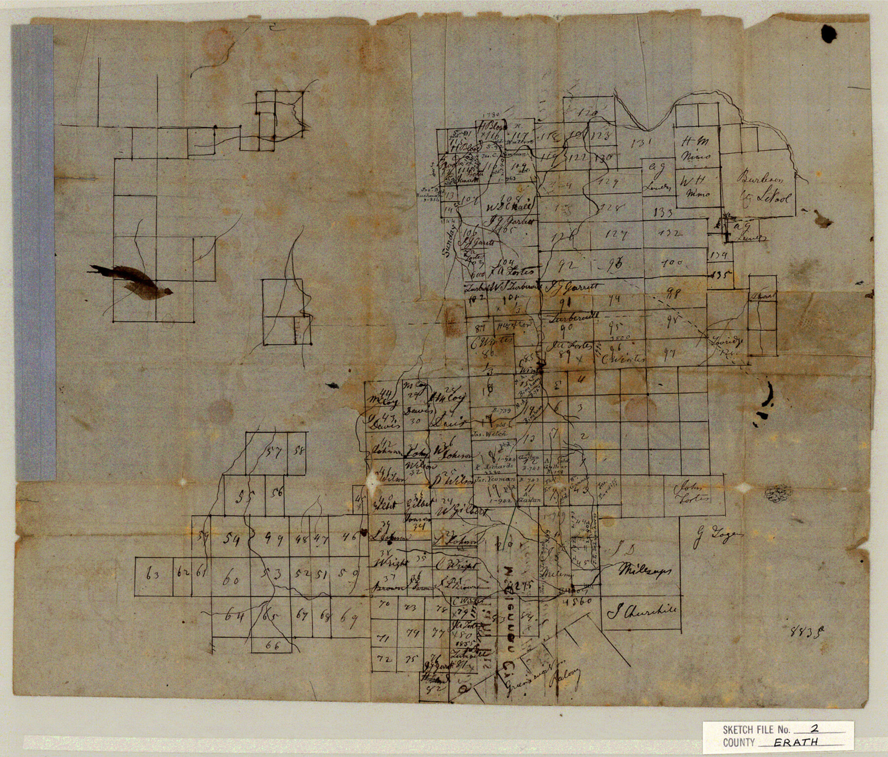
Erath County Sketch File 2
Head Waters of Poloxy & of Fork Creek
-
Map/Doc
11463
-
Collection
General Map Collection
-
Object Dates
1858/3/6 (File Date)
-
People and Organizations
J.B. Erath (Surveyor/Engineer)
-
Counties
Erath Palo Pinto
-
Subjects
Surveying Sketch File
-
Height x Width
13.2 x 15.5 inches
33.5 x 39.4 cm
-
Medium
paper, manuscript
-
Features
Sunday Creek
[Poloxy Creek]
[Fork Creek]
Part of: General Map Collection
Montague County Working Sketch 34

Print $20.00
- Digital $50.00
Montague County Working Sketch 34
1979
Size 20.3 x 15.0 inches
Map/Doc 71100
Jeff Davis County Working Sketch 39

Print $40.00
- Digital $50.00
Jeff Davis County Working Sketch 39
1981
Size 52.1 x 38.0 inches
Map/Doc 66534
Flight Mission No. DAG-17K, Frame 63, Matagorda County

Print $20.00
- Digital $50.00
Flight Mission No. DAG-17K, Frame 63, Matagorda County
1952
Size 18.6 x 22.3 inches
Map/Doc 86325
Intracoastal Waterway in Texas - Corpus Christi to Point Isabel including Arroyo Colorado to Mo. Pac. R.R. Bridge Near Harlingen

Print $20.00
- Digital $50.00
Intracoastal Waterway in Texas - Corpus Christi to Point Isabel including Arroyo Colorado to Mo. Pac. R.R. Bridge Near Harlingen
1933
Size 27.9 x 40.8 inches
Map/Doc 61878
Flight Mission No. CUI-1H, Frame 168, Milam County

Print $20.00
- Digital $50.00
Flight Mission No. CUI-1H, Frame 168, Milam County
1951
Size 18.4 x 22.3 inches
Map/Doc 86610
Map of Robertson Co.

Print $20.00
- Digital $50.00
Map of Robertson Co.
1889
Size 44.0 x 39.1 inches
Map/Doc 3996
Bandera County Working Sketch 59

Print $20.00
- Digital $50.00
Bandera County Working Sketch 59
2003
Size 41.1 x 33.9 inches
Map/Doc 78346
Nacogdoches County Boundary File 1b

Print $20.00
- Digital $50.00
Nacogdoches County Boundary File 1b
Size 21.2 x 4.9 inches
Map/Doc 57580
Pecos County Working Sketch 22

Print $20.00
- Digital $50.00
Pecos County Working Sketch 22
1926
Size 14.3 x 23.5 inches
Map/Doc 71492
Uvalde County Working Sketch 15

Print $20.00
- Digital $50.00
Uvalde County Working Sketch 15
1945
Size 18.5 x 26.9 inches
Map/Doc 72085
Travis County Appraisal District Plat Map 2_0601

Print $20.00
- Digital $50.00
Travis County Appraisal District Plat Map 2_0601
Size 21.5 x 26.4 inches
Map/Doc 94235
Sabine County Sketch File 11

Print $4.00
Sabine County Sketch File 11
Size 6.2 x 8.3 inches
Map/Doc 35629
You may also like
Lubbock County Sketch File 7

Print $8.00
- Digital $50.00
Lubbock County Sketch File 7
1906
Size 7.4 x 8.5 inches
Map/Doc 30422
Sutton County Sketch File 26

Print $20.00
- Digital $50.00
Sutton County Sketch File 26
1929
Size 19.6 x 14.8 inches
Map/Doc 12383
Red River County Sketch File 5

Print $4.00
- Digital $50.00
Red River County Sketch File 5
Size 7.9 x 4.8 inches
Map/Doc 35102
Right of Way and Track Map Houston & Texas Central R.R. operated by the T. and N. O. R.R. Co., Fort Worth Branch

Print $40.00
- Digital $50.00
Right of Way and Track Map Houston & Texas Central R.R. operated by the T. and N. O. R.R. Co., Fort Worth Branch
1918
Size 30.7 x 56.4 inches
Map/Doc 64542
Pecos County Sketch File 92

Print $4.00
- Digital $50.00
Pecos County Sketch File 92
1954
Size 11.2 x 8.6 inches
Map/Doc 33988
General Highway Map, McMullen County, Texas

Print $20.00
General Highway Map, McMullen County, Texas
1961
Size 24.7 x 18.3 inches
Map/Doc 79592
Hansford County, Texas

Print $20.00
- Digital $50.00
Hansford County, Texas
1880
Size 19.9 x 18.9 inches
Map/Doc 528
[Sketch for Mineral Application 33721 - 33725 Incl. - Padre and Mustang Island]
![65664, [Sketch for Mineral Application 33721 - 33725 Incl. - Padre and Mustang Island], General Map Collection](https://historictexasmaps.com/wmedia_w700/maps/65664.tif.jpg)
Print $20.00
- Digital $50.00
[Sketch for Mineral Application 33721 - 33725 Incl. - Padre and Mustang Island]
Size 42.3 x 22.6 inches
Map/Doc 65664
Henderson County

Print $40.00
- Digital $50.00
Henderson County
1897
Size 30.2 x 60.8 inches
Map/Doc 66859
Reagan County Sketch File 14

Print $6.00
- Digital $50.00
Reagan County Sketch File 14
Size 11.3 x 8.8 inches
Map/Doc 34993
Outer Continental Shelf Leasing Maps (Louisiana Offshore Operations)

Print $20.00
- Digital $50.00
Outer Continental Shelf Leasing Maps (Louisiana Offshore Operations)
1959
Size 18.3 x 14.5 inches
Map/Doc 76112
Hemphill County Working Sketch 21

Print $40.00
- Digital $50.00
Hemphill County Working Sketch 21
1973
Size 79.0 x 32.6 inches
Map/Doc 66116