Bexar County Sketch File 27
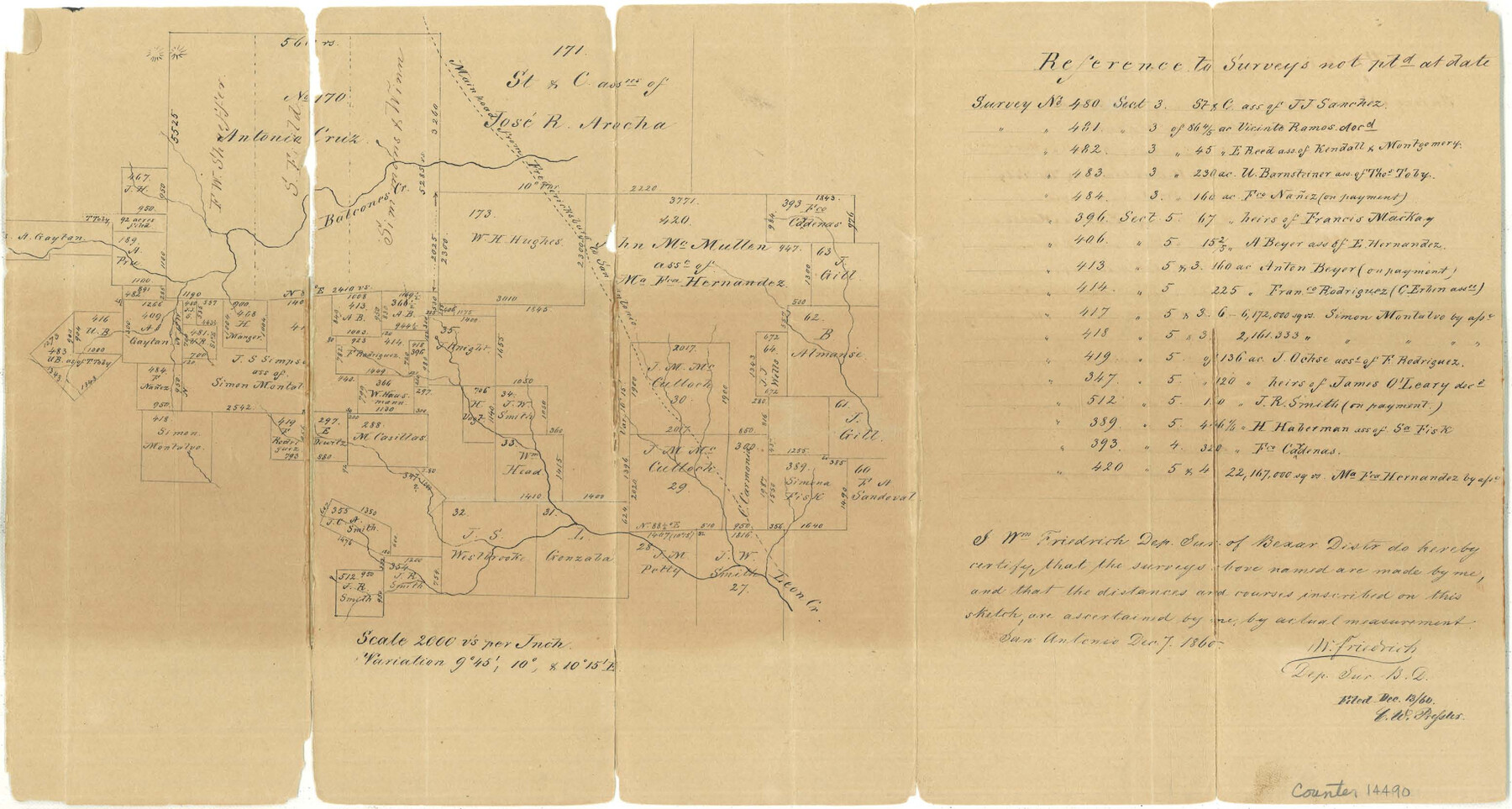
[Sketch of surveys near Leon Creek, Balcones Creek, and Friedricksburg Road]
-
Map/Doc
14490
-
Collection
General Map Collection
-
Object Dates
1860/12/7 (Creation Date)
1860/12/13 (File Date)
-
People and Organizations
Wm. Friedrich (Surveyor/Engineer)
-
Counties
Bexar
-
Subjects
Surveying Sketch File
-
Height x Width
8.6 x 6.5 inches
21.8 x 16.5 cm
-
Medium
paper, manuscript
-
Scale
1" = 2000 varas
-
Features
Main road from Fredericksburg to San Antonio
Fredericksburg Road
San Antonio Road
Balcones Creek
Leon Creek
Part of: General Map Collection
Gregg County Rolled Sketch 26

Print $40.00
- Digital $50.00
Gregg County Rolled Sketch 26
1937
Size 25.8 x 129.0 inches
Map/Doc 9077
Colorado County Sketch File 9

Print $3.00
- Digital $50.00
Colorado County Sketch File 9
Size 11.3 x 17.0 inches
Map/Doc 11134
Montague County Working Sketch 10

Print $20.00
- Digital $50.00
Montague County Working Sketch 10
1940
Size 13.1 x 28.2 inches
Map/Doc 71076
Houston County Working Sketch 37

Print $20.00
- Digital $50.00
Houston County Working Sketch 37
2006
Size 33.0 x 40.0 inches
Map/Doc 83627
Webb County Working Sketch 31

Print $20.00
- Digital $50.00
Webb County Working Sketch 31
1937
Size 23.2 x 26.0 inches
Map/Doc 72396
Pecos County Boundary File 69

Print $22.00
- Digital $50.00
Pecos County Boundary File 69
Size 7.8 x 3.4 inches
Map/Doc 57890
Culberson County Working Sketch 7

Print $20.00
- Digital $50.00
Culberson County Working Sketch 7
1912
Size 21.2 x 17.7 inches
Map/Doc 68459
Brazos River, Harlem-Imperial Farms Project

Print $4.00
- Digital $50.00
Brazos River, Harlem-Imperial Farms Project
1931
Size 29.4 x 26.6 inches
Map/Doc 65285
Nueces County Rolled Sketch 128

Print $20.00
- Digital $50.00
Nueces County Rolled Sketch 128
1998
Size 18.3 x 24.5 inches
Map/Doc 7163
Leon County Rolled Sketch 22

Print $20.00
- Digital $50.00
Leon County Rolled Sketch 22
1983
Size 29.9 x 27.1 inches
Map/Doc 6608
Briscoe County

Print $20.00
- Digital $50.00
Briscoe County
1930
Size 46.2 x 39.2 inches
Map/Doc 1787
Schleicher County Working Sketch 3

Print $20.00
- Digital $50.00
Schleicher County Working Sketch 3
1914
Size 23.2 x 17.6 inches
Map/Doc 63805
You may also like
From Citizens Living in Red River County for the Creation of a New County (Unnamed), Undated

Print $20.00
From Citizens Living in Red River County for the Creation of a New County (Unnamed), Undated
2020
Size 16.6 x 21.7 inches
Map/Doc 96405
Jeff Davis County Working Sketch 25

Print $20.00
- Digital $50.00
Jeff Davis County Working Sketch 25
1959
Size 28.9 x 32.2 inches
Map/Doc 66520
Harris County Rolled Sketch 100

Print $20.00
- Digital $50.00
Harris County Rolled Sketch 100
2002
Size 24.2 x 36.9 inches
Map/Doc 77535
Map of Leon County

Print $20.00
- Digital $50.00
Map of Leon County
1871
Size 25.4 x 23.2 inches
Map/Doc 4579
Midland County Rolled Sketch 4

Print $40.00
- Digital $50.00
Midland County Rolled Sketch 4
Size 43.5 x 85.6 inches
Map/Doc 10696
The Republic County of Shelby. January 28, 1839

Print $20.00
The Republic County of Shelby. January 28, 1839
2020
Size 21.1 x 21.7 inches
Map/Doc 96281
Tom Green County Sketch File 72

Print $20.00
- Digital $50.00
Tom Green County Sketch File 72
1949
Size 24.3 x 28.5 inches
Map/Doc 12448
Nueces County Rolled Sketch 45

Print $20.00
- Digital $50.00
Nueces County Rolled Sketch 45
1941
Size 41.0 x 40.9 inches
Map/Doc 10203

Hill County Working Sketch 4

Print $20.00
- Digital $50.00
Hill County Working Sketch 4
1982
Size 25.3 x 23.3 inches
Map/Doc 66190
Taylor County Sketch File A

Print $2.00
- Digital $50.00
Taylor County Sketch File A
Size 8.8 x 11.3 inches
Map/Doc 37773
