Lamb County Sketch File 15
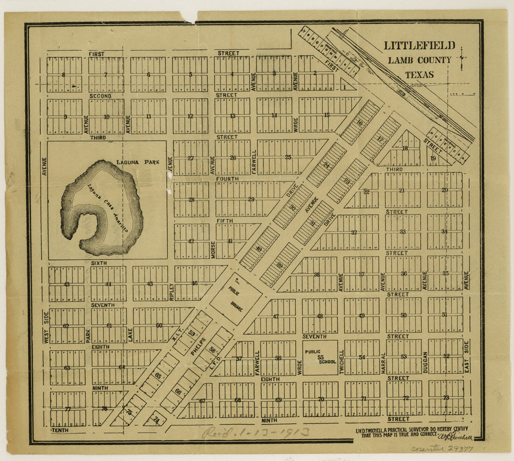
Littlefield, Lamb County, Texas
-
Map/Doc
29377
-
Collection
General Map Collection
-
Object Dates
1/13/1913 (File Date)
-
People and Organizations
W.D. Twichell (Surveyor/Engineer)
-
Counties
Lamb
-
Subjects
Surveying Sketch File City
-
Height x Width
9.8 x 10.9 inches
24.9 x 27.7 cm
-
Medium
paper, etching/engraving/lithograph
-
Features
Farwell Avenue
Tenth Street
LFD Drive
XIT Drive
Ninth Street
Eighth Street
West Side Avenue
East Side Avenue
Duggan Avenue
Harral Avenue
Twichell Avenue
Seventh Street
First Street
Phelps Avenue
Ripley Avenue
Lake Avenue
Sixth Street
Laguna Park
Wroe Avenue
Morse Avenue
Fifth Street
Fourth Street
Third Street
Second Street
Part of: General Map Collection
Wilson County Working Sketch 5

Print $20.00
- Digital $50.00
Wilson County Working Sketch 5
1954
Size 32.4 x 33.9 inches
Map/Doc 72585
Commemorative Map of the Republic of Texas, 1845

Print $27.06
Commemorative Map of the Republic of Texas, 1845
1986
Size 32.7 x 26.7 inches
Map/Doc 89023
Harrison County Working Sketch 10

Print $20.00
- Digital $50.00
Harrison County Working Sketch 10
1957
Size 25.8 x 24.6 inches
Map/Doc 66030
Victoria County Sketch File V1

Print $10.00
- Digital $50.00
Victoria County Sketch File V1
1896
Size 14.6 x 9.2 inches
Map/Doc 39525
Uvalde County Working Sketch 30

Print $20.00
- Digital $50.00
Uvalde County Working Sketch 30
1962
Size 27.9 x 40.9 inches
Map/Doc 72100
Yoakum County Rolled Sketch 4

Print $20.00
- Digital $50.00
Yoakum County Rolled Sketch 4
Size 19.1 x 24.9 inches
Map/Doc 8289
Foard County Sketch File 35

Print $20.00
- Digital $50.00
Foard County Sketch File 35
Size 25.2 x 24.8 inches
Map/Doc 6067
Medina County Rolled Sketch 18

Print $20.00
- Digital $50.00
Medina County Rolled Sketch 18
Size 33.4 x 25.3 inches
Map/Doc 6751
San Augustine County Working Sketch 25

Print $20.00
- Digital $50.00
San Augustine County Working Sketch 25
1976
Size 28.0 x 36.6 inches
Map/Doc 63713
Wise County Working Sketch 10

Print $20.00
- Digital $50.00
Wise County Working Sketch 10
Size 17.4 x 18.4 inches
Map/Doc 72624

Reagan County Working Sketch 49

Print $20.00
- Digital $50.00
Reagan County Working Sketch 49
1990
Size 40.4 x 25.2 inches
Map/Doc 71892
You may also like
Clay County Working Sketch 1
Print $20.00
- Digital $50.00
Clay County Working Sketch 1
Size 30.7 x 29.3 inches
Map/Doc 68024
Shelby County Sketch File 25

Print $6.00
- Digital $50.00
Shelby County Sketch File 25
Size 4.8 x 5.3 inches
Map/Doc 36657
La Salle County Rolled Sketch 2

Print $20.00
- Digital $50.00
La Salle County Rolled Sketch 2
1915
Size 25.2 x 23.2 inches
Map/Doc 6567
[Blocks S and M19 Resurvey]
![91440, [Blocks S and M19 Resurvey], Twichell Survey Records](https://historictexasmaps.com/wmedia_w700/maps/91440-1.tif.jpg)
Print $20.00
- Digital $50.00
[Blocks S and M19 Resurvey]
1903
Size 37.0 x 30.0 inches
Map/Doc 91440
Travis County Working Sketch 13

Print $20.00
- Digital $50.00
Travis County Working Sketch 13
1930
Size 20.5 x 27.3 inches
Map/Doc 69397
Atascosa County Sketch File 3a

Print $6.00
- Digital $50.00
Atascosa County Sketch File 3a
1856
Size 7.1 x 8.8 inches
Map/Doc 13736
Outer Continental Shelf Leasing Maps (Louisiana Offshore Operations)

Print $20.00
- Digital $50.00
Outer Continental Shelf Leasing Maps (Louisiana Offshore Operations)
1954
Size 13.0 x 15.0 inches
Map/Doc 76111
Upton County Working Sketch 40

Print $40.00
- Digital $50.00
Upton County Working Sketch 40
1959
Size 37.5 x 63.7 inches
Map/Doc 69536
The Republic County of Matagorda. Proposed, Late Fall 1837

Print $20.00
The Republic County of Matagorda. Proposed, Late Fall 1837
2020
Size 21.0 x 21.7 inches
Map/Doc 96214

Eleven County Map

Print $40.00
- Digital $50.00
Eleven County Map
Size 37.7 x 59.1 inches
Map/Doc 89807
Gaines County Working Sketch 13

Print $20.00
- Digital $50.00
Gaines County Working Sketch 13
1954
Size 36.8 x 39.4 inches
Map/Doc 69313