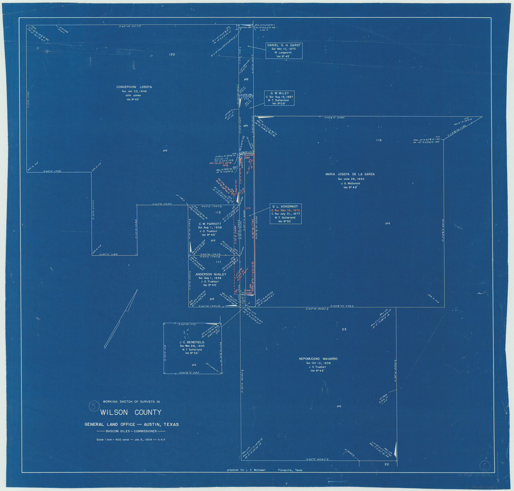
Wilson County Working Sketch 5
-
Map/Doc
72585
-
Collection
General Map Collection
-
Object Dates
1/5/1954 (Creation Date)
-
People and Organizations
Herman H. Forbes (Draftsman)
-
Counties
Wilson
-
Subjects
Surveying Working Sketch
-
Height x Width
32.4 x 33.9 inches
82.3 x 86.1 cm
-
Scale
1" = 400 varas
Part of: General Map Collection
Flight Mission No. CRE-1R, Frame 64, Jackson County

Print $20.00
- Digital $50.00
Flight Mission No. CRE-1R, Frame 64, Jackson County
1956
Size 15.9 x 15.9 inches
Map/Doc 85327
Terrell County Rolled Sketch 37

Print $20.00
- Digital $50.00
Terrell County Rolled Sketch 37
1940
Size 23.8 x 33.3 inches
Map/Doc 7941
Sectional Map No. 2 of the lands and the line of the Texas & Pacific Ry. Co. in Howard, Martin, Andrews, Midland and Tom Green Counties

Print $20.00
- Digital $50.00
Sectional Map No. 2 of the lands and the line of the Texas & Pacific Ry. Co. in Howard, Martin, Andrews, Midland and Tom Green Counties
1885
Size 18.9 x 23.2 inches
Map/Doc 4861
Gregg County Rolled Sketch 28

Print $77.00
- Digital $50.00
Gregg County Rolled Sketch 28
1934
Size 10.1 x 15.2 inches
Map/Doc 45639
Brewster County Sketch File FN-32

Print $8.00
- Digital $50.00
Brewster County Sketch File FN-32
Size 11.1 x 8.7 inches
Map/Doc 15854
Williamson County Sketch File 31

Print $14.00
- Digital $50.00
Williamson County Sketch File 31
1991
Size 11.2 x 8.4 inches
Map/Doc 40386
Moore County Rolled Sketch 14A

Print $20.00
- Digital $50.00
Moore County Rolled Sketch 14A
1981
Size 21.8 x 27.5 inches
Map/Doc 6831
Flight Mission No. CRC-5R, Frame 20, Chambers County

Print $20.00
- Digital $50.00
Flight Mission No. CRC-5R, Frame 20, Chambers County
1956
Size 18.8 x 22.4 inches
Map/Doc 84942
Kimble County Working Sketch 25

Print $20.00
- Digital $50.00
Kimble County Working Sketch 25
1937
Size 22.9 x 22.7 inches
Map/Doc 70093
Brooks County Rolled Sketch 14

Print $20.00
- Digital $50.00
Brooks County Rolled Sketch 14
Size 28.4 x 32.8 inches
Map/Doc 5339
Frio County Rolled Sketch 25

Print $20.00
- Digital $50.00
Frio County Rolled Sketch 25
1965
Size 25.0 x 30.6 inches
Map/Doc 5925
Terrell County Rolled Sketch 27

Print $20.00
- Digital $50.00
Terrell County Rolled Sketch 27
Size 24.8 x 20.7 inches
Map/Doc 7934
You may also like
Presidio County Sketch File 64

Print $20.00
- Digital $50.00
Presidio County Sketch File 64
1938
Size 16.5 x 26.5 inches
Map/Doc 11719
Smith County Working Sketch 16

Print $20.00
- Digital $50.00
Smith County Working Sketch 16
1988
Size 33.6 x 44.9 inches
Map/Doc 63901
Maverick County Rolled Sketch 25

Print $20.00
- Digital $50.00
Maverick County Rolled Sketch 25
1999
Size 24.6 x 24.7 inches
Map/Doc 82574
Military Map of parts of Kansas, Nebraska and Dakota by Lieut. G.K. Warren, Top. Engrs. from the Explorations made by him in 1855, 56 & 57 exhibiting also routes reconnouered [sic] and surveyed by various other government officers
![93995, Military Map of parts of Kansas, Nebraska and Dakota by Lieut. G.K. Warren, Top. Engrs. from the Explorations made by him in 1855, 56 & 57 exhibiting also routes reconnouered [sic] and surveyed by various other government officers, Rees-Jones Digital Map Collection](https://historictexasmaps.com/wmedia_w700/maps/93995-1.tif.jpg)
Print $20.00
- Digital $50.00
Military Map of parts of Kansas, Nebraska and Dakota by Lieut. G.K. Warren, Top. Engrs. from the Explorations made by him in 1855, 56 & 57 exhibiting also routes reconnouered [sic] and surveyed by various other government officers
Size 19.9 x 35.6 inches
Map/Doc 93995
McMullen County Working Sketch 28

Print $20.00
- Digital $50.00
McMullen County Working Sketch 28
1954
Size 25.6 x 22.4 inches
Map/Doc 70729
Section 16, Block "A", Sylvan Sanders Survey

Print $20.00
- Digital $50.00
Section 16, Block "A", Sylvan Sanders Survey
1953
Size 24.7 x 16.0 inches
Map/Doc 92715
General Highway Map, Goliad County, Texas

Print $20.00
General Highway Map, Goliad County, Texas
1940
Size 18.7 x 25.1 inches
Map/Doc 79101
Jackson County

Print $20.00
- Digital $50.00
Jackson County
1920
Size 46.9 x 40.1 inches
Map/Doc 95541
English Field Notes of the Spanish Archives - Books DB3 & WR

English Field Notes of the Spanish Archives - Books DB3 & WR
1835
Map/Doc 96548
Edwards County Working Sketch 79

Print $40.00
- Digital $50.00
Edwards County Working Sketch 79
1962
Size 58.5 x 26.6 inches
Map/Doc 68955
Index to Titles, Field Notes, Plats: Spanish Archives

Index to Titles, Field Notes, Plats: Spanish Archives
1880
Map/Doc 94534
Block 33, Township 5 South

Print $2.00
- Digital $50.00
Block 33, Township 5 South
1875
Size 8.9 x 9.7 inches
Map/Doc 90751