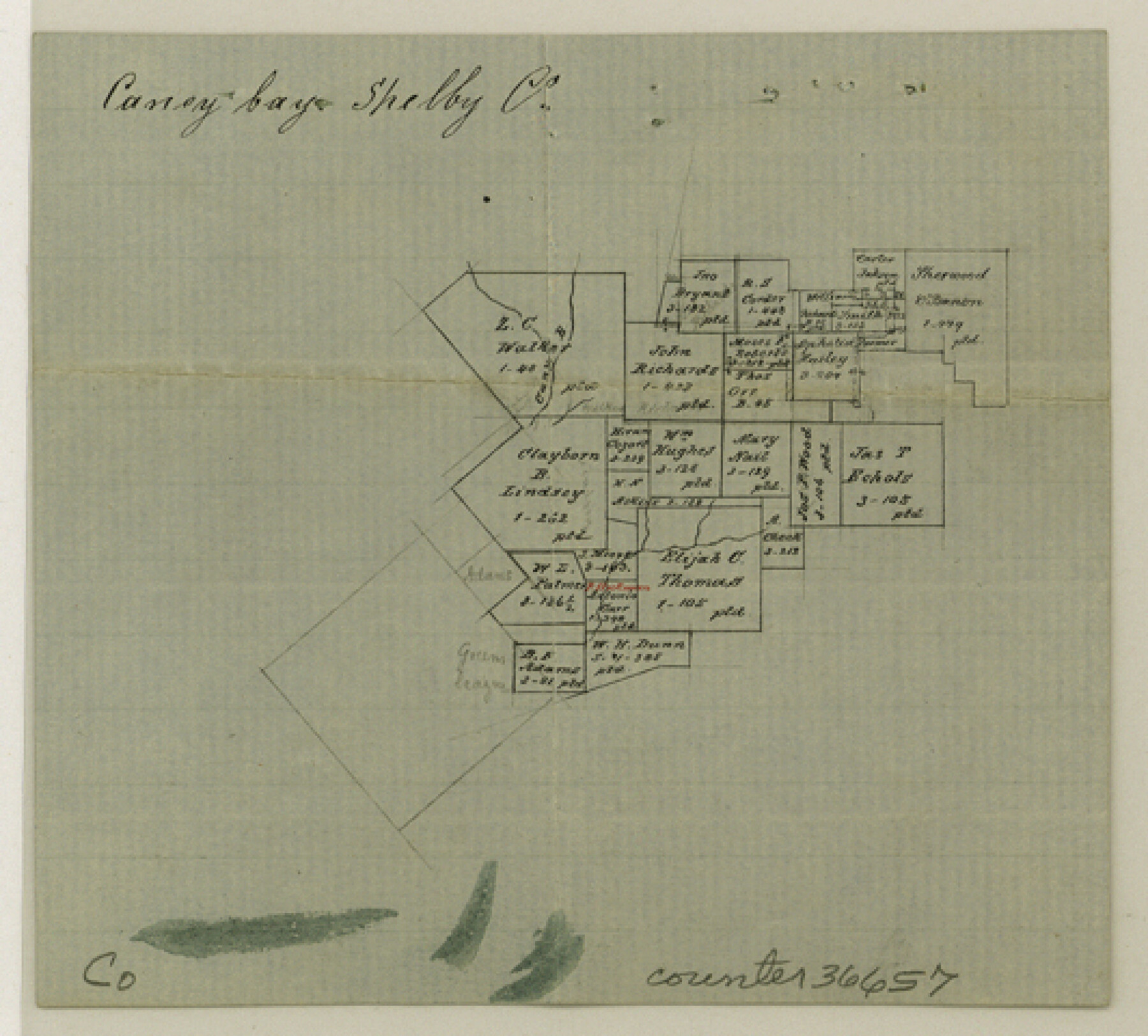
Shelby County Sketch File 25
[Office sketches of surveys in the northwest corner of the county near the Z.C. Walker survey]
-
Map/Doc
36657
-
Collection
General Map Collection
-
People and Organizations
George W. Locke (Surveyor/Engineer)
-
Counties
Shelby
-
Subjects
Surveying Sketch File
-
Height x Width
4.8 x 5.3 inches
12.2 x 13.5 cm
-
Medium
paper, manuscript
-
Features
Caney Bayou
Part of: General Map Collection
Flight Mission No. BRA-16M, Frame 115, Jefferson County

Print $20.00
- Digital $50.00
Flight Mission No. BRA-16M, Frame 115, Jefferson County
1953
Size 18.5 x 22.2 inches
Map/Doc 85725
Burnet County Sketch File 31

Print $4.00
- Digital $50.00
Burnet County Sketch File 31
1875
Size 12.7 x 8.1 inches
Map/Doc 16748
Dawson County Working Sketch 4

Print $20.00
- Digital $50.00
Dawson County Working Sketch 4
1926
Size 32.2 x 23.8 inches
Map/Doc 68549
Jack County Sketch File 18c

Print $60.00
- Digital $50.00
Jack County Sketch File 18c
Size 20.0 x 30.7 inches
Map/Doc 11828
Sterling County Rolled Sketch 17

Print $40.00
- Digital $50.00
Sterling County Rolled Sketch 17
Size 61.0 x 48.4 inches
Map/Doc 9949
Galveston County NRC Article 33.136 Location Key Sheet

Print $20.00
- Digital $50.00
Galveston County NRC Article 33.136 Location Key Sheet
1994
Size 27.0 x 23.0 inches
Map/Doc 77018
Culberson County Working Sketch 61

Print $40.00
- Digital $50.00
Culberson County Working Sketch 61
1974
Size 74.9 x 34.0 inches
Map/Doc 68515
Pecos County Rolled Sketch DK1

Print $20.00
- Digital $50.00
Pecos County Rolled Sketch DK1
1938
Size 36.2 x 43.7 inches
Map/Doc 9713
Gulf Oil Corp. Fishgide - Port O'Connor

Gulf Oil Corp. Fishgide - Port O'Connor
1960
Size 12.0 x 22.0 inches
Map/Doc 75982
Map of the Rio Grande Frontier, Texas, East of Fort McIntosh and South of the Mex. National RR.

Print $20.00
- Digital $50.00
Map of the Rio Grande Frontier, Texas, East of Fort McIntosh and South of the Mex. National RR.
1892
Size 26.1 x 39.8 inches
Map/Doc 4660
Map of the West Indies engraved to illustrate Mitchell's new intermediate geography

Print $20.00
- Digital $50.00
Map of the West Indies engraved to illustrate Mitchell's new intermediate geography
1885
Size 9.0 x 12.2 inches
Map/Doc 93524
Flight Mission No. DAH-9M, Frame 155, Orange County

Print $20.00
- Digital $50.00
Flight Mission No. DAH-9M, Frame 155, Orange County
1953
Size 18.6 x 22.6 inches
Map/Doc 86854
You may also like
Loving County Working Sketch 6

Print $40.00
- Digital $50.00
Loving County Working Sketch 6
1947
Size 31.3 x 51.0 inches
Map/Doc 70638
G. T. Oliver's Subdivisions of the Motley and Foard County School Leagues situated in Bailey Co., Texas

Print $20.00
- Digital $50.00
G. T. Oliver's Subdivisions of the Motley and Foard County School Leagues situated in Bailey Co., Texas
1909
Size 24.5 x 37.3 inches
Map/Doc 90181
Kimble County Sketch File 11

Print $40.00
- Digital $50.00
Kimble County Sketch File 11
1882
Size 20.5 x 10.2 inches
Map/Doc 28933
Dallas County Boundary File 3

Print $6.00
- Digital $50.00
Dallas County Boundary File 3
Size 14.2 x 8.6 inches
Map/Doc 52120
Val Verde County

Print $20.00
- Digital $50.00
Val Verde County
1944
Size 42.0 x 37.0 inches
Map/Doc 63103
Sketch showing position of Asylum Lands Blk. 4, H. & T. C. R.R. Co. & river surveys on north side of Middle Concho, Tom Green Co.

Print $20.00
- Digital $50.00
Sketch showing position of Asylum Lands Blk. 4, H. & T. C. R.R. Co. & river surveys on north side of Middle Concho, Tom Green Co.
Size 14.4 x 20.6 inches
Map/Doc 388
Liberty County Sketch File 11

Print $6.00
- Digital $50.00
Liberty County Sketch File 11
1858
Size 11.8 x 10.0 inches
Map/Doc 29905
Flight Mission No. CRC-2R, Frame 194, Chambers County

Print $20.00
- Digital $50.00
Flight Mission No. CRC-2R, Frame 194, Chambers County
1956
Size 18.8 x 22.6 inches
Map/Doc 84772
Refugio County Working Sketch 9

Print $20.00
- Digital $50.00
Refugio County Working Sketch 9
1941
Size 38.6 x 28.3 inches
Map/Doc 63518
Map of Velasco

Print $20.00
- Digital $50.00
Map of Velasco
1906
Size 32.1 x 39.4 inches
Map/Doc 95357
Jim Wells County Working Sketch Graphic Index

Print $20.00
- Digital $50.00
Jim Wells County Working Sketch Graphic Index
1966
Size 41.7 x 29.5 inches
Map/Doc 76597
[Surveys in the Bexar District along the Sabinal River and Rancheros Creek]
![95, [Surveys in the Bexar District along the Sabinal River and Rancheros Creek], General Map Collection](https://historictexasmaps.com/wmedia_w700/maps/95.tif.jpg)
Print $2.00
- Digital $50.00
[Surveys in the Bexar District along the Sabinal River and Rancheros Creek]
1846
Size 8.6 x 7.8 inches
Map/Doc 95