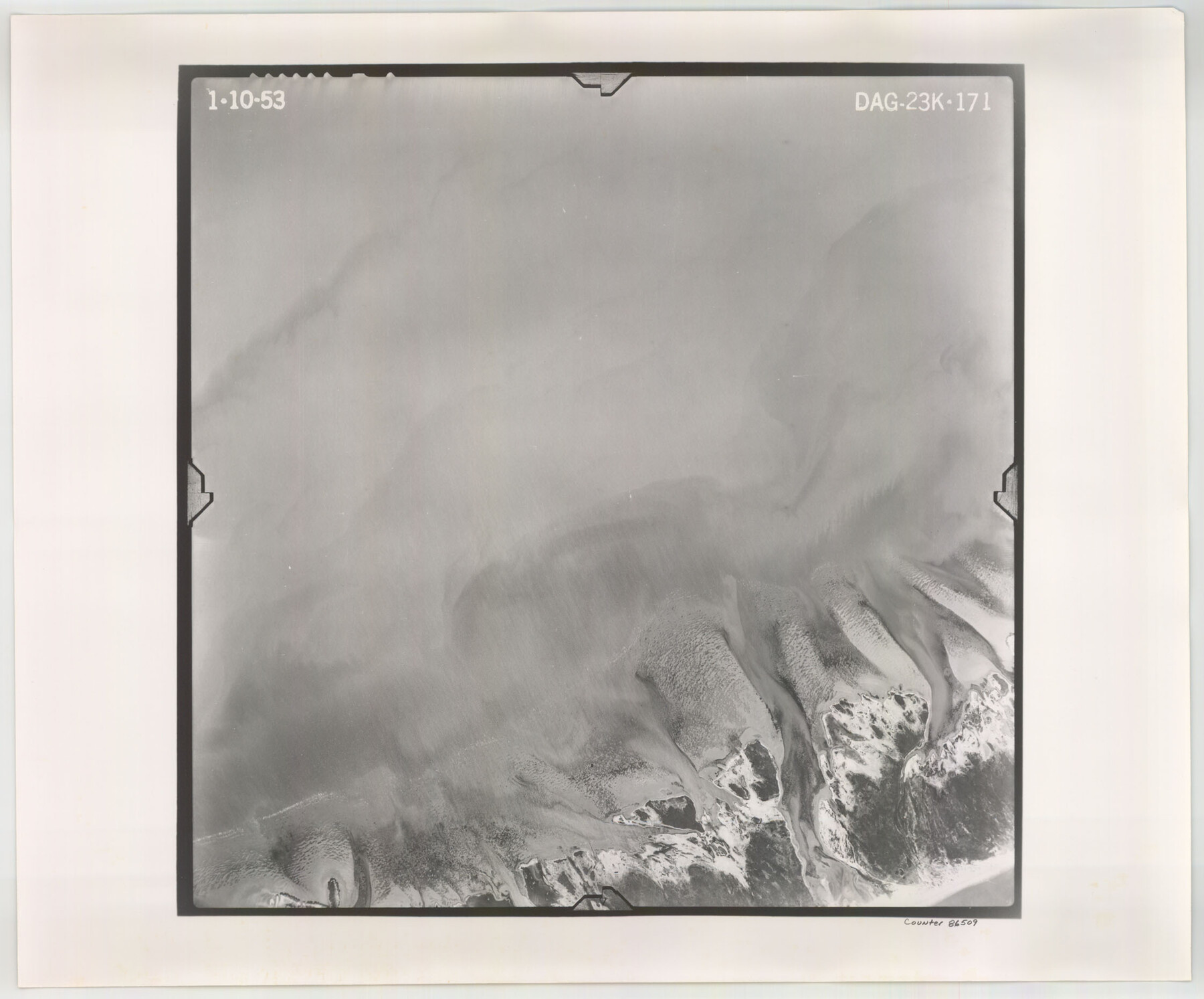
Flight Mission No. DAG-23K, Frame 171, Matagorda County
DAG-23K-171
-
Map/Doc
86509
-
Collection
General Map Collection
-
Object Dates
1953/1/10 (Creation Date)
-
People and Organizations
U. S. Department of Agriculture (Publisher)
-
Counties
Matagorda
-
Subjects
Aerial Photograph
-
Height x Width
18.6 x 22.4 inches
47.2 x 56.9 cm
-
Comments
Flown by Aero Exploration Company of Tulsa, Oklahoma.
Part of: General Map Collection
Wise County Working Sketch 5

Print $20.00
- Digital $50.00
Wise County Working Sketch 5
1948
Size 25.7 x 23.4 inches
Map/Doc 72619
Lynn County Boundary File 7

Print $10.00
- Digital $50.00
Lynn County Boundary File 7
Size 11.5 x 8.8 inches
Map/Doc 56642
Zavala County Working Sketch 10

Print $20.00
- Digital $50.00
Zavala County Working Sketch 10
1954
Size 30.4 x 38.8 inches
Map/Doc 62085
Uvalde County Rolled Sketch 13

Print $20.00
- Digital $50.00
Uvalde County Rolled Sketch 13
Size 38.3 x 32.4 inches
Map/Doc 10065
Sherman County

Print $20.00
- Digital $50.00
Sherman County
1889
Size 22.3 x 19.0 inches
Map/Doc 4036
Callahan County Rolled Sketch 5

Print $40.00
- Digital $50.00
Callahan County Rolled Sketch 5
Size 52.0 x 44.1 inches
Map/Doc 5382
Montgomery County Texas Historical Map

Montgomery County Texas Historical Map
Size 23.2 x 35.5 inches
Map/Doc 94403
Hays County Sketch File 16a

Print $4.00
- Digital $50.00
Hays County Sketch File 16a
1871
Size 8.2 x 9.7 inches
Map/Doc 26229
Cherokee County Working Sketch 23
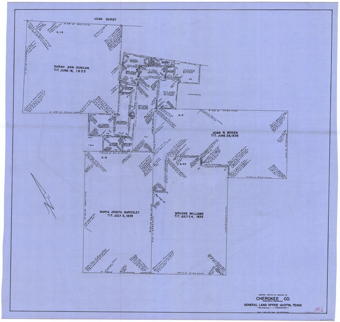
Print $20.00
- Digital $50.00
Cherokee County Working Sketch 23
1972
Size 44.4 x 46.9 inches
Map/Doc 67978
Crosby County Working Sketch 8

Print $20.00
- Digital $50.00
Crosby County Working Sketch 8
1938
Size 42.3 x 37.2 inches
Map/Doc 68442
Map of Roberts County

Print $20.00
- Digital $50.00
Map of Roberts County
1932
Size 42.9 x 39.0 inches
Map/Doc 95626
Current Miscellaneous File 27

Print $4.00
- Digital $50.00
Current Miscellaneous File 27
1952
Size 10.8 x 8.3 inches
Map/Doc 73909
You may also like
Gillespie County Rolled Sketch 8

Print $20.00
- Digital $50.00
Gillespie County Rolled Sketch 8
2008
Size 20.2 x 19.1 inches
Map/Doc 89014
Nueces County Sketch File 59

Print $23.00
- Digital $50.00
Nueces County Sketch File 59
1989
Size 11.2 x 8.6 inches
Map/Doc 32951
Limestone County Working Sketch 18

Print $20.00
- Digital $50.00
Limestone County Working Sketch 18
1962
Size 45.5 x 38.7 inches
Map/Doc 70568
Webb County Rolled Sketch 7

Print $20.00
- Digital $50.00
Webb County Rolled Sketch 7
Size 29.1 x 43.7 inches
Map/Doc 8173
Republic Counties. January 1, 1845

Print $20.00
Republic Counties. January 1, 1845
2020
Size 24.5 x 21.7 inches
Map/Doc 96318
Gregg County Sketch File 14

Print $6.00
- Digital $50.00
Gregg County Sketch File 14
1946
Size 14.3 x 8.8 inches
Map/Doc 24613
Calhoun County Rolled Sketch 26

Print $40.00
- Digital $50.00
Calhoun County Rolled Sketch 26
1941
Size 25.5 x 112.1 inches
Map/Doc 8556
Flight Mission No. DIX-8P, Frame 66, Aransas County

Print $20.00
- Digital $50.00
Flight Mission No. DIX-8P, Frame 66, Aransas County
1956
Size 18.6 x 22.2 inches
Map/Doc 83897
Live Oak County Rolled Sketch 3

Print $20.00
- Digital $50.00
Live Oak County Rolled Sketch 3
1944
Size 31.2 x 47.2 inches
Map/Doc 10630
Map of McMullen County

Print $20.00
Map of McMullen County
1879
Size 28.6 x 19.3 inches
Map/Doc 88975
Part of the boundary between the United States and Texas; north of Sabine River from the 36th to the 72nd mile mound

Print $3.00
- Digital $50.00
Part of the boundary between the United States and Texas; north of Sabine River from the 36th to the 72nd mile mound
1842
Size 12.0 x 8.8 inches
Map/Doc 93770
Galveston County Rolled Sketch 46A

Print $20.00
- Digital $50.00
Galveston County Rolled Sketch 46A
2000
Size 24.9 x 37.6 inches
Map/Doc 5982