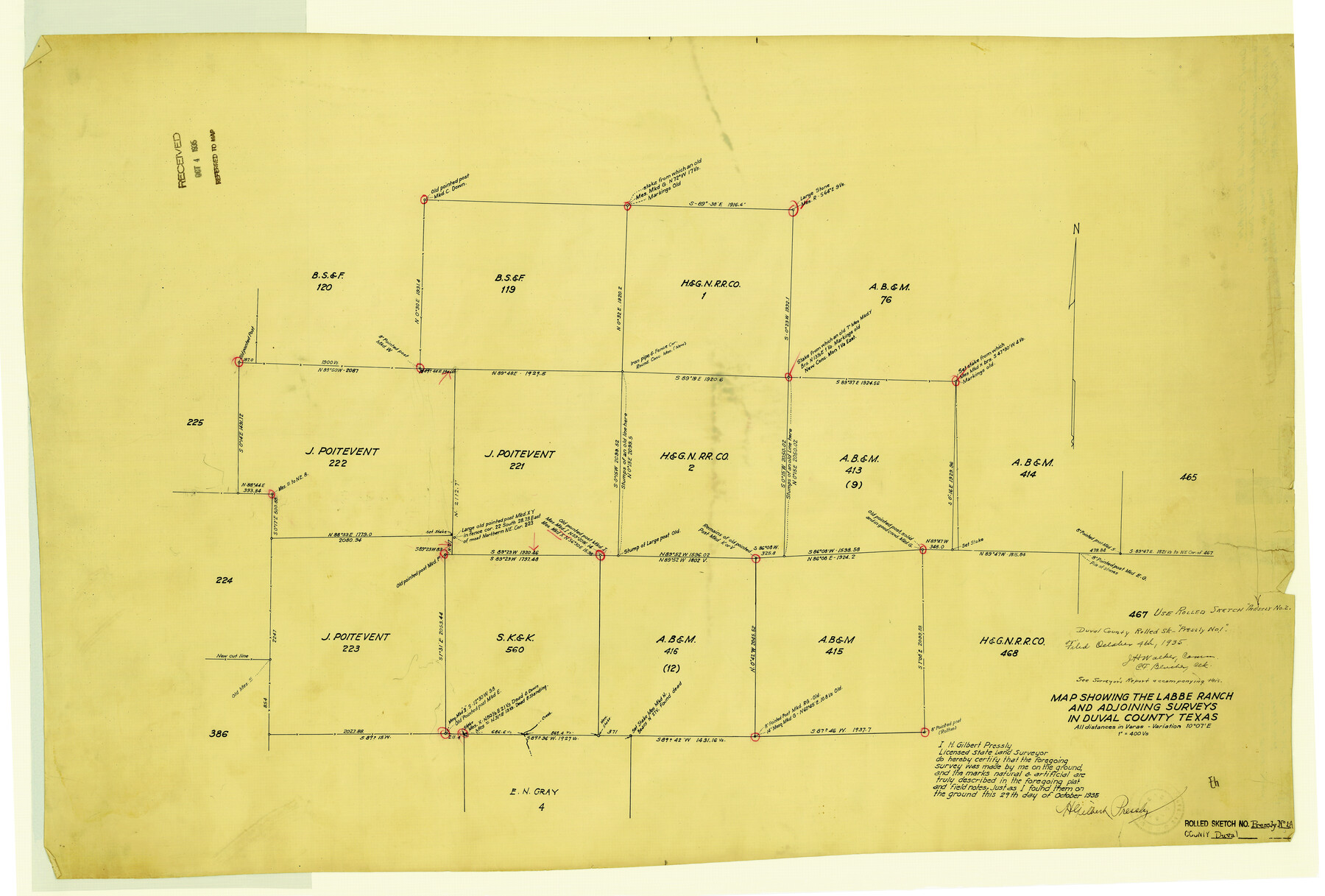
Duval County Rolled Sketch Pressly No. 1A
Map showing the Labbe Ranch and adjoining surveys in Duval County, Texas
-
Map/Doc
5769
-
Collection
General Map Collection
-
Object Dates
1935/10/4 (File Date)
1935/10/29 (Creation Date)
-
People and Organizations
H. Gilbert Pressly (Surveyor/Engineer)
-
Counties
Duval
-
Subjects
Surveying Rolled Sketch
-
Height x Width
25.4 x 37.6 inches
64.5 x 95.5 cm
-
Medium
blueprint/diazo
-
Scale
1" = 400 varas
Part of: General Map Collection
[Surveys in Austin's Colony at Matagorda Bay and along the Trespalacios and Colorado Rivers]
![147, [Surveys in Austin's Colony at Matagorda Bay and along the Trespalacios and Colorado Rivers], General Map Collection](https://historictexasmaps.com/wmedia_w700/maps/147.tif.jpg)
Print $20.00
- Digital $50.00
[Surveys in Austin's Colony at Matagorda Bay and along the Trespalacios and Colorado Rivers]
1821
Size 31.6 x 20.5 inches
Map/Doc 147
Gonzales County Sketch File 3

Print $24.00
- Digital $50.00
Gonzales County Sketch File 3
1871
Size 12.6 x 8.3 inches
Map/Doc 24361
Garza County Rolled Sketch 6A

Print $20.00
- Digital $50.00
Garza County Rolled Sketch 6A
1902
Size 29.2 x 35.9 inches
Map/Doc 9053
United States, 1956 Revised Edition

Print $40.00
- Digital $50.00
United States, 1956 Revised Edition
1946
Size 48.0 x 36.3 inches
Map/Doc 78631
Flight Mission No. DQN-5K, Frame 47, Calhoun County

Print $20.00
- Digital $50.00
Flight Mission No. DQN-5K, Frame 47, Calhoun County
1953
Size 18.5 x 22.2 inches
Map/Doc 84392
Roberts County Boundary File 2b

Print $38.00
- Digital $50.00
Roberts County Boundary File 2b
Size 9.0 x 7.0 inches
Map/Doc 58344
Wilbarger County Sketch File 9

Print $4.00
- Digital $50.00
Wilbarger County Sketch File 9
1885
Size 12.7 x 8.2 inches
Map/Doc 40181
Tyler County Sketch File 11

Print $4.00
- Digital $50.00
Tyler County Sketch File 11
1849
Size 11.3 x 5.6 inches
Map/Doc 38650
Map of Grimes Co.

Print $20.00
- Digital $50.00
Map of Grimes Co.
1881
Size 32.6 x 17.5 inches
Map/Doc 66843
Pecos County Working Sketch 114

Print $40.00
- Digital $50.00
Pecos County Working Sketch 114
1972
Size 75.7 x 38.0 inches
Map/Doc 71587
Martin County Working Sketch Graphic Index

Print $20.00
- Digital $50.00
Martin County Working Sketch Graphic Index
1933
Size 44.1 x 37.8 inches
Map/Doc 76631
Orange County Working Sketch 53

Print $20.00
- Digital $50.00
Orange County Working Sketch 53
2007
Size 34.1 x 46.0 inches
Map/Doc 87371
You may also like
[Surveying sketch of J.C. Payne, J.D. Polk, Jos. English, et al in Travis County, Texas]
![75801, [Surveying sketch of J.C. Payne, J.D. Polk, Jos. English, et al in Travis County, Texas], Maddox Collection](https://historictexasmaps.com/wmedia_w700/maps/75801.tif.jpg)
Print $20.00
- Digital $50.00
[Surveying sketch of J.C. Payne, J.D. Polk, Jos. English, et al in Travis County, Texas]
Size 18.3 x 23.5 inches
Map/Doc 75801
Flight Mission No. BRE-1P, Frame 69, Nueces County

Print $20.00
- Digital $50.00
Flight Mission No. BRE-1P, Frame 69, Nueces County
1956
Size 18.3 x 22.1 inches
Map/Doc 86651
Flight Mission No. CUG-1P, Frame 162, Kleberg County

Print $20.00
- Digital $50.00
Flight Mission No. CUG-1P, Frame 162, Kleberg County
1956
Size 18.7 x 22.2 inches
Map/Doc 86169
Map of the United States and Canada

Print $2.00
- Digital $50.00
Map of the United States and Canada
1853
Size 6.2 x 4.2 inches
Map/Doc 93919
Hudspeth County Rolled Sketch 33

Print $40.00
- Digital $50.00
Hudspeth County Rolled Sketch 33
Size 59.0 x 24.9 inches
Map/Doc 8345
Current Miscellaneous File 35

Print $10.00
- Digital $50.00
Current Miscellaneous File 35
Size 14.2 x 8.7 inches
Map/Doc 73947
Flight Mission No. DQO-2K, Frame 94, Galveston County

Print $20.00
- Digital $50.00
Flight Mission No. DQO-2K, Frame 94, Galveston County
1952
Size 18.7 x 22.4 inches
Map/Doc 85021
Gonzales County Rolled Sketch 1

Print $20.00
- Digital $50.00
Gonzales County Rolled Sketch 1
1917
Size 21.9 x 23.9 inches
Map/Doc 6027
Tom Green County Sketch File 46 1/2

Print $40.00
- Digital $50.00
Tom Green County Sketch File 46 1/2
1882
Size 12.7 x 19.6 inches
Map/Doc 12440
Plat showing surveys made for N. Vasquez, Sr. of Casa Piedra, Texas in Block 312, T. C. Ry. Co.

Print $20.00
- Digital $50.00
Plat showing surveys made for N. Vasquez, Sr. of Casa Piedra, Texas in Block 312, T. C. Ry. Co.
1947
Size 16.5 x 22.3 inches
Map/Doc 2062
Live Oak County

Print $40.00
- Digital $50.00
Live Oak County
1899
Size 52.1 x 37.5 inches
Map/Doc 78423
Dawson County Working Sketch 14

Print $20.00
- Digital $50.00
Dawson County Working Sketch 14
1952
Size 15.5 x 12.8 inches
Map/Doc 68558