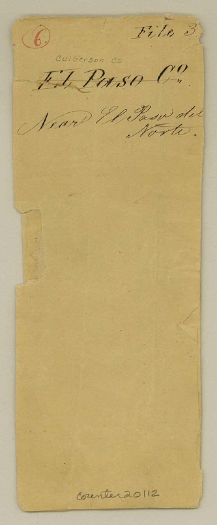
Culberson County Sketch File 3
[Multiple sketches regarding surveys along the Rio Grande]
-
Map/Doc
20112
-
Collection
General Map Collection
-
People and Organizations
Stevenson Archer (Surveyor/Engineer)
Robert B. Hays (Surveyor/Engineer)
E. von Rosenberg (Draftsman)
-
Counties
Culberson
-
Subjects
Surveying Sketch File
-
Height x Width
8.0 x 3.3 inches
20.3 x 8.4 cm
-
Medium
paper, manuscript
-
Scale
1:4000
-
Features
El Paso del Norte
Rio Grande
[Road to] Fort Bliss
Fort Bliss
Old [Rio Grande] River
Rio Viejo
Ysleta
Part of: General Map Collection
Van Zandt County Sketch File 34

Print $4.00
- Digital $50.00
Van Zandt County Sketch File 34
1861
Size 7.8 x 15.0 inches
Map/Doc 39472
Flight Mission No. CRC-3R, Frame 20, Chambers County

Print $20.00
- Digital $50.00
Flight Mission No. CRC-3R, Frame 20, Chambers County
1956
Size 18.6 x 22.2 inches
Map/Doc 84794
Ward County Rolled Sketch 18

Print $20.00
- Digital $50.00
Ward County Rolled Sketch 18
1949
Size 31.6 x 34.0 inches
Map/Doc 10109
Matagorda County Aerial Photograph Index Sheet 4

Print $20.00
- Digital $50.00
Matagorda County Aerial Photograph Index Sheet 4
1953
Size 23.6 x 19.5 inches
Map/Doc 83725
Controlled Mosaic by Jack Amman Photogrammetric Engineers, Inc - Sheet 51

Print $20.00
- Digital $50.00
Controlled Mosaic by Jack Amman Photogrammetric Engineers, Inc - Sheet 51
1954
Size 20.0 x 24.0 inches
Map/Doc 83510
Cass County Working Sketch 8

Print $20.00
- Digital $50.00
Cass County Working Sketch 8
1937
Size 20.2 x 16.1 inches
Map/Doc 67911
Duval County Working Sketch 16

Print $20.00
- Digital $50.00
Duval County Working Sketch 16
1939
Size 14.6 x 25.3 inches
Map/Doc 68729
Harris County Historic Topographic 3

Print $20.00
- Digital $50.00
Harris County Historic Topographic 3
1916
Size 29.4 x 22.5 inches
Map/Doc 65813
Map Showing Resurvey of Capitol Leagues, Bailey, Lamb & Castro Co's.

Print $20.00
- Digital $50.00
Map Showing Resurvey of Capitol Leagues, Bailey, Lamb & Castro Co's.
1918
Size 17.3 x 42.5 inches
Map/Doc 1758
Zavala County Rolled Sketch 21

Print $20.00
- Digital $50.00
Zavala County Rolled Sketch 21
Size 27.6 x 38.4 inches
Map/Doc 8324
Montgomery County Sketch File 10

Print $4.00
- Digital $50.00
Montgomery County Sketch File 10
Size 16.2 x 9.2 inches
Map/Doc 31798
Nacogdoches Co.

Print $20.00
- Digital $50.00
Nacogdoches Co.
1905
Size 47.6 x 40.5 inches
Map/Doc 66948
You may also like
Upton County Sketch File 14a

Print $18.00
- Digital $50.00
Upton County Sketch File 14a
1927
Size 14.5 x 9.1 inches
Map/Doc 38864
Port of Galveston, Galveston Channel

Print $40.00
- Digital $50.00
Port of Galveston, Galveston Channel
1979
Size 38.0 x 66.2 inches
Map/Doc 83333
Duval County Sketch File 71

Print $4.00
- Digital $50.00
Duval County Sketch File 71
1953
Size 15.2 x 9.0 inches
Map/Doc 21458
Menard County Sketch File 16

Print $6.00
- Digital $50.00
Menard County Sketch File 16
1892
Size 12.8 x 8.4 inches
Map/Doc 31513
Schleicher County

Print $20.00
- Digital $50.00
Schleicher County
1898
Size 23.1 x 36.3 inches
Map/Doc 615
Udell -V- Hughes Sketch

Print $20.00
- Digital $50.00
Udell -V- Hughes Sketch
Size 28.8 x 19.4 inches
Map/Doc 90481
Coryell County Boundary File 1c

Print $6.00
- Digital $50.00
Coryell County Boundary File 1c
Size 10.2 x 8.1 inches
Map/Doc 51901
Flight Mission No. DQN-2K, Frame 159, Calhoun County

Print $20.00
- Digital $50.00
Flight Mission No. DQN-2K, Frame 159, Calhoun County
1953
Size 18.5 x 22.2 inches
Map/Doc 84321
Wise County Rolled Sketch 8

Print $20.00
- Digital $50.00
Wise County Rolled Sketch 8
Size 24.0 x 36.0 inches
Map/Doc 93554
Flight Mission No. CRE-2R, Frame 157, Jackson County

Print $20.00
- Digital $50.00
Flight Mission No. CRE-2R, Frame 157, Jackson County
1956
Size 18.4 x 22.3 inches
Map/Doc 85368
Engineer map showing engineer information at 23 O'Clock 23 Oct. 1918 drawn under direction of Col. W.A. Mitchell

Print $20.00
Engineer map showing engineer information at 23 O'Clock 23 Oct. 1918 drawn under direction of Col. W.A. Mitchell
1918
Size 19.6 x 12.5 inches
Map/Doc 94127
Goliad County Working Sketch 6

Print $20.00
- Digital $50.00
Goliad County Working Sketch 6
1930
Size 20.9 x 22.2 inches
Map/Doc 63196