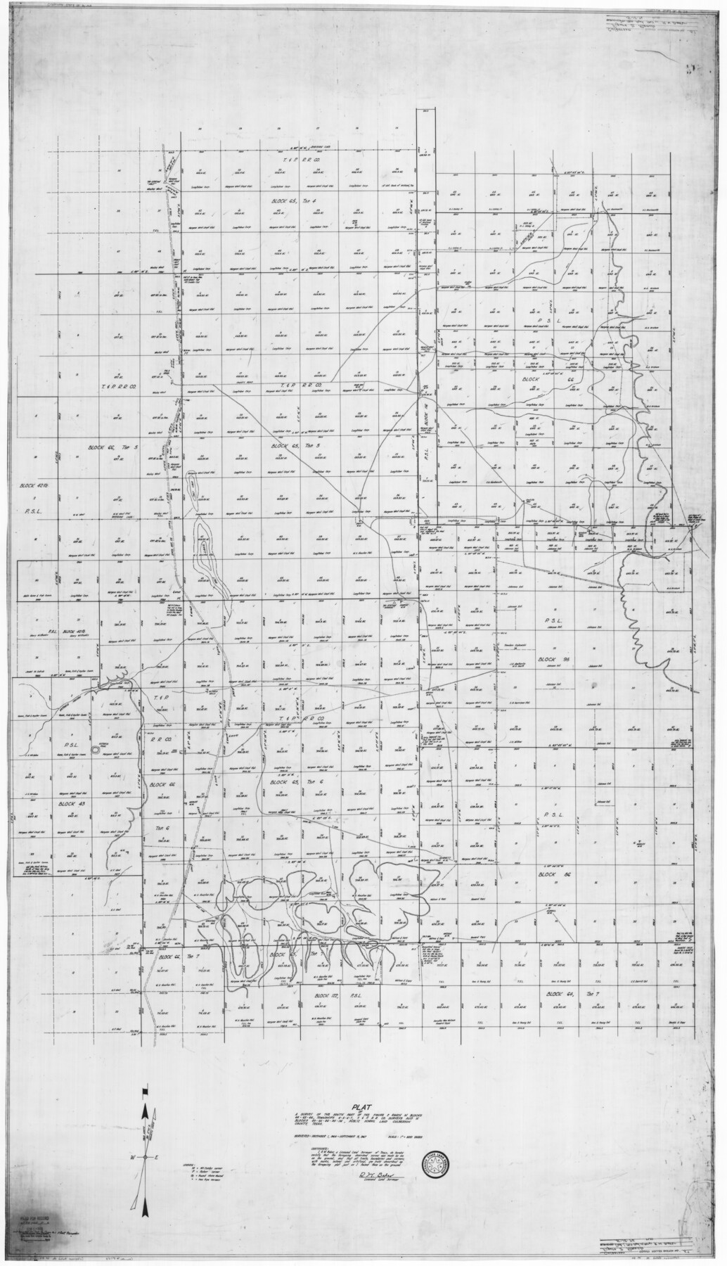
Culberson County Rolled Sketch 57
Figure 2 Ranch, Culberson County, Texas
-
Map/Doc
8758
-
Collection
General Map Collection
-
Object Dates
1967 (Creation Date)
1976/5/12 (File Date)
-
People and Organizations
R.W. Baker (Surveyor/Engineer)
-
Counties
Culberson
-
Subjects
Surveying Rolled Sketch
-
Height x Width
76.9 x 44.2 inches
195.3 x 112.3 cm
Part of: General Map Collection
Crockett County Rolled Sketch 95

Print $20.00
- Digital $50.00
Crockett County Rolled Sketch 95
1985
Size 24.6 x 28.8 inches
Map/Doc 5634
Flight Mission No. BRA-7M, Frame 33, Jefferson County

Print $20.00
- Digital $50.00
Flight Mission No. BRA-7M, Frame 33, Jefferson County
1953
Size 18.6 x 22.4 inches
Map/Doc 85484
Fort Bend County Sketch File 6

Print $2.00
- Digital $50.00
Fort Bend County Sketch File 6
Size 4.7 x 8.4 inches
Map/Doc 22891
Armstrong County Sketch File A-1

Print $40.00
- Digital $50.00
Armstrong County Sketch File A-1
Size 28.1 x 34.3 inches
Map/Doc 10842
Grayson County Working Sketch 11

Print $20.00
- Digital $50.00
Grayson County Working Sketch 11
1951
Size 27.9 x 24.3 inches
Map/Doc 63250
Pecos County Working Sketch 50

Print $20.00
- Digital $50.00
Pecos County Working Sketch 50
1947
Size 21.1 x 13.4 inches
Map/Doc 71522

Duval County Working Sketch 5
Print $40.00
- Digital $50.00
Duval County Working Sketch 5
1933
Size 43.2 x 54.2 inches
Map/Doc 68718
Presidio County Sketch File 101

Print $20.00
- Digital $50.00
Presidio County Sketch File 101
1888
Size 21.1 x 20.3 inches
Map/Doc 11725
El Paso County Working Sketch 47

Print $20.00
- Digital $50.00
El Paso County Working Sketch 47
Size 28.3 x 30.5 inches
Map/Doc 69069
Tyler County Sketch File 13

Print $6.00
- Digital $50.00
Tyler County Sketch File 13
1857
Size 8.7 x 13.0 inches
Map/Doc 38653
Young County Sketch File 7

Print $6.00
- Digital $50.00
Young County Sketch File 7
1856
Size 8.4 x 9.2 inches
Map/Doc 40859
You may also like
General Highway Map. Detail of Cities and Towns in Dallas County, Texas [Dallas and vicinity]
![79433, General Highway Map. Detail of Cities and Towns in Dallas County, Texas [Dallas and vicinity], Texas State Library and Archives](https://historictexasmaps.com/wmedia_w700/maps/79433.tif.jpg)
Print $20.00
General Highway Map. Detail of Cities and Towns in Dallas County, Texas [Dallas and vicinity]
1961
Size 18.1 x 24.5 inches
Map/Doc 79433
Van Zandt County

Print $20.00
- Digital $50.00
Van Zandt County
1921
Size 45.5 x 41.0 inches
Map/Doc 16914
[Notes and map showing Public School Land Block K between Yoakum and Terry Counties]
![92010, [Notes and map showing Public School Land Block K between Yoakum and Terry Counties], Twichell Survey Records](https://historictexasmaps.com/wmedia_w700/maps/92010-1.tif.jpg)
Print $2.00
- Digital $50.00
[Notes and map showing Public School Land Block K between Yoakum and Terry Counties]
Size 8.3 x 5.7 inches
Map/Doc 92010
Duval County Working Sketch 56

Print $20.00
- Digital $50.00
Duval County Working Sketch 56
1989
Size 26.7 x 27.2 inches
Map/Doc 68780
Cameron County Rolled Sketch Z6

Print $20.00
- Digital $50.00
Cameron County Rolled Sketch Z6
1937
Size 28.3 x 33.8 inches
Map/Doc 5404
Hale County Sketch File 5-5a

Print $30.00
- Digital $50.00
Hale County Sketch File 5-5a
1891
Size 17.7 x 38.3 inches
Map/Doc 10467
Flight Mission No. CUG-3P, Frame 89, Kleberg County

Print $20.00
- Digital $50.00
Flight Mission No. CUG-3P, Frame 89, Kleberg County
1956
Size 18.4 x 22.1 inches
Map/Doc 86259
Map of Angelina County

Print $40.00
- Digital $50.00
Map of Angelina County
1899
Size 40.1 x 53.6 inches
Map/Doc 4868
The Republic County of Robertson. Spring 1842

Print $20.00
The Republic County of Robertson. Spring 1842
2020
Size 16.9 x 21.7 inches
Map/Doc 96263
Edwards County Working Sketch 115

Print $20.00
- Digital $50.00
Edwards County Working Sketch 115
1973
Size 39.6 x 43.9 inches
Map/Doc 68991
Gray County Sketch File 10

Print $14.00
- Digital $50.00
Gray County Sketch File 10
Size 9.7 x 6.3 inches
Map/Doc 24445
