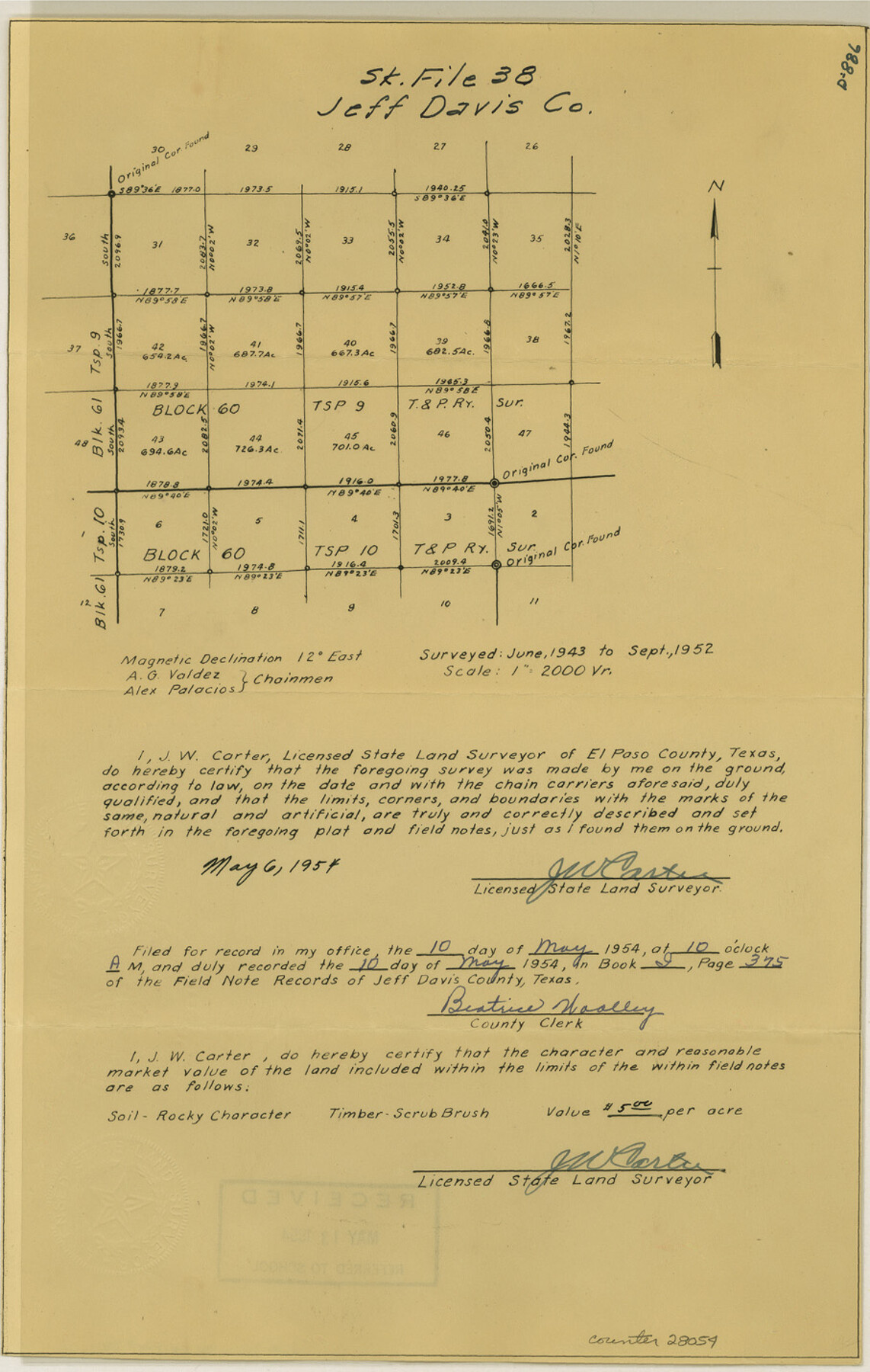
Jeff Davis County Sketch File 38
[Sketch of southwest part of Block 60, Township 9, T. & P. RR. Co.]
-
Map/Doc
28054
-
Collection
General Map Collection
-
Object Dates
1952 (Creation Date)
5/13/1954 (File Date)
6/1943 (Survey Date)
9/1952 (Survey Date)
5/6/1954 (Creation Date)
-
People and Organizations
J.W. Carter (Surveyor/Engineer)
A.G. Valdez (Chainman)
Alex Palacios (Chainman)
-
Counties
Jeff Davis
-
Subjects
Surveying Sketch File
-
Height x Width
14.3 x 9.1 inches
36.3 x 23.1 cm
-
Medium
paper, manuscript
-
Scale
1:2000
Part of: General Map Collection
Refugio County Rolled Sketch 8

Print $40.00
- Digital $50.00
Refugio County Rolled Sketch 8
1954
Size 53.9 x 46.7 inches
Map/Doc 9860
Texas City Channel, Texas, Channel and Turning Basin Dredging - Sheet 5

Print $20.00
- Digital $50.00
Texas City Channel, Texas, Channel and Turning Basin Dredging - Sheet 5
1958
Size 28.2 x 40.9 inches
Map/Doc 61835
Burnet County Working Sketch 5

Print $20.00
- Digital $50.00
Burnet County Working Sketch 5
1956
Size 30.0 x 19.3 inches
Map/Doc 67848
Wharton County Sketch File 3a

Print $4.00
- Digital $50.00
Wharton County Sketch File 3a
1875
Size 6.8 x 4.6 inches
Map/Doc 39917
Comal County Sketch File 6

Print $6.00
- Digital $50.00
Comal County Sketch File 6
Size 10.3 x 8.1 inches
Map/Doc 19008
Map of San Patricio County

Print $40.00
- Digital $50.00
Map of San Patricio County
1896
Size 31.6 x 51.2 inches
Map/Doc 63018
Outer Continental Shelf Leasing Maps (Texas Offshore Operations)

Print $20.00
- Digital $50.00
Outer Continental Shelf Leasing Maps (Texas Offshore Operations)
Size 17.0 x 18.4 inches
Map/Doc 75847
Bowie County Sketch File 5

Print $4.00
- Digital $50.00
Bowie County Sketch File 5
Size 10.1 x 7.5 inches
Map/Doc 14837
Galveston County Sketch File 5a

Print $4.00
- Digital $50.00
Galveston County Sketch File 5a
1847
Size 12.6 x 8.2 inches
Map/Doc 23360
Texas Official Travel Map

Digital $50.00
Texas Official Travel Map
Size 33.3 x 36.2 inches
Map/Doc 94302
Coke County Sketch File 19

Print $20.00
- Digital $50.00
Coke County Sketch File 19
Size 18.5 x 25.0 inches
Map/Doc 11110
Rusk County Rolled Sketch 7

Print $20.00
- Digital $50.00
Rusk County Rolled Sketch 7
Size 43.0 x 37.3 inches
Map/Doc 9876
You may also like

Stonewall County

Print $20.00
- Digital $50.00
Stonewall County
1902
Size 39.6 x 38.5 inches
Map/Doc 63049
Flight Mission No. CGI-4N, Frame 26, Cameron County

Print $20.00
- Digital $50.00
Flight Mission No. CGI-4N, Frame 26, Cameron County
1954
Size 18.8 x 22.3 inches
Map/Doc 84659
Denton County Working Sketch 5

Print $20.00
- Digital $50.00
Denton County Working Sketch 5
1956
Size 23.9 x 19.4 inches
Map/Doc 68610
Pecos County Rolled Sketch DK1

Print $20.00
- Digital $50.00
Pecos County Rolled Sketch DK1
1938
Size 36.2 x 43.7 inches
Map/Doc 9713
Live Oak County Working Sketch 27

Print $20.00
- Digital $50.00
Live Oak County Working Sketch 27
1982
Size 12.7 x 17.4 inches
Map/Doc 70612
Crosby County Sketch File 12a

Print $20.00
- Digital $50.00
Crosby County Sketch File 12a
1901
Size 21.5 x 30.9 inches
Map/Doc 11248
Midland County Boundary File 5

Print $6.00
- Digital $50.00
Midland County Boundary File 5
Size 9.6 x 6.0 inches
Map/Doc 57195
Llano County Sketch File 12

Print $14.00
- Digital $50.00
Llano County Sketch File 12
1889
Size 14.0 x 8.5 inches
Map/Doc 30380

Gonzales County

Print $40.00
- Digital $50.00
Gonzales County
1986
Size 41.6 x 54.7 inches
Map/Doc 73160
Mason County Sketch File 19

Print $20.00
- Digital $50.00
Mason County Sketch File 19
1901
Size 19.1 x 20.9 inches
Map/Doc 12036