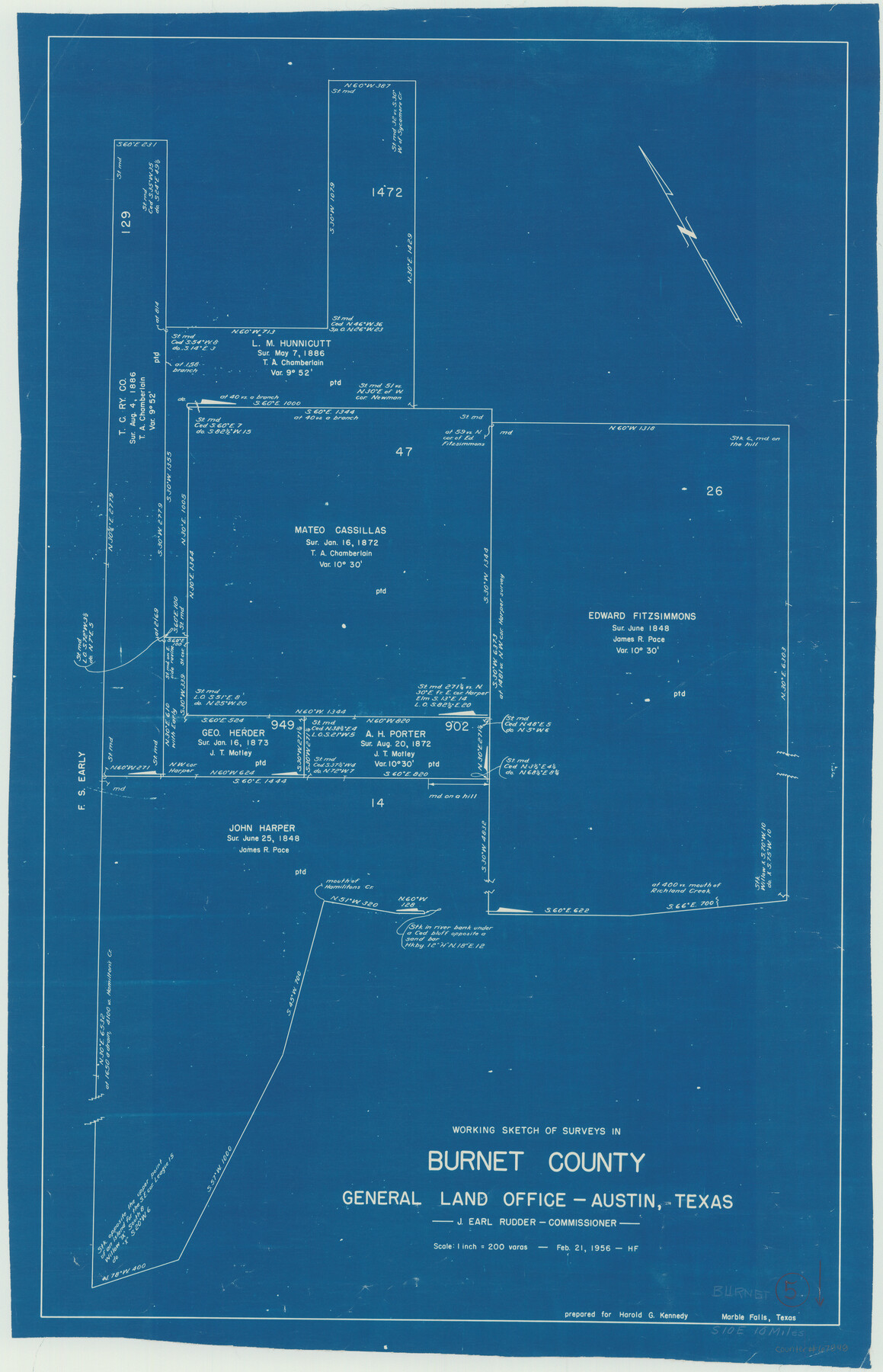
Burnet County Working Sketch 5
-
Map/Doc
67848
-
Collection
General Map Collection
-
Object Dates
2/21/1956 (Creation Date)
-
People and Organizations
Herman Forbes (Draftsman)
-
Counties
Burnet
-
Subjects
Surveying Working Sketch
-
Height x Width
30.0 x 19.3 inches
76.2 x 49.0 cm
-
Scale
1" = 200 varas
Part of: General Map Collection
Fort Bend County Working Sketch 32

Print $20.00
- Digital $50.00
Fort Bend County Working Sketch 32
2000
Size 36.5 x 42.5 inches
Map/Doc 69238
Reagan County Working Sketch 25

Print $20.00
- Digital $50.00
Reagan County Working Sketch 25
1958
Size 45.8 x 42.8 inches
Map/Doc 71867
Harris County Rolled Sketch 79

Print $20.00
- Digital $50.00
Harris County Rolled Sketch 79
1955
Size 30.4 x 25.0 inches
Map/Doc 6115
Wilbarger County Sketch File 20

Print $4.00
- Digital $50.00
Wilbarger County Sketch File 20
1885
Size 12.7 x 8.2 inches
Map/Doc 40217
Harrison County

Print $20.00
- Digital $50.00
Harrison County
1920
Size 43.0 x 40.0 inches
Map/Doc 77305
Liberty County Rolled Sketch 15

Print $20.00
- Digital $50.00
Liberty County Rolled Sketch 15
2015
Size 36.1 x 24.4 inches
Map/Doc 94023
1910 Map of the City of Houston and vicinity

Print $20.00
- Digital $50.00
1910 Map of the City of Houston and vicinity
1910
Size 20.5 x 23.4 inches
Map/Doc 97452
Old Miscellaneous File 38

Print $40.00
- Digital $50.00
Old Miscellaneous File 38
1841
Size 57.8 x 33.9 inches
Map/Doc 75282
Medina County

Print $40.00
- Digital $50.00
Medina County
1915
Size 53.2 x 44.8 inches
Map/Doc 10790
Bowie County Sketch File 7d

Print $40.00
- Digital $50.00
Bowie County Sketch File 7d
1927
Size 16.2 x 13.7 inches
Map/Doc 10944
Pecos County Working Sketch 35

Print $20.00
- Digital $50.00
Pecos County Working Sketch 35
1939
Size 32.5 x 26.7 inches
Map/Doc 71507
Houston County Sketch File 3

Print $6.00
- Digital $50.00
Houston County Sketch File 3
Size 13.1 x 8.2 inches
Map/Doc 26748
You may also like
Flight Mission No. BRE-2P, Frame 101, Nueces County

Print $20.00
- Digital $50.00
Flight Mission No. BRE-2P, Frame 101, Nueces County
1956
Size 18.4 x 22.2 inches
Map/Doc 86786
Kendall County Boundary File 3

Print $36.00
- Digital $50.00
Kendall County Boundary File 3
Size 9.4 x 37.5 inches
Map/Doc 55756
Atascosa County Sketch File 31

Print $4.00
- Digital $50.00
Atascosa County Sketch File 31
1910
Size 9.4 x 4.3 inches
Map/Doc 13825
Atascosa County Working Sketch 36

Print $20.00
- Digital $50.00
Atascosa County Working Sketch 36
2008
Size 29.4 x 44.5 inches
Map/Doc 88878
Map of City of Brownfield, Texas

Print $20.00
- Digital $50.00
Map of City of Brownfield, Texas
1953
Size 44.4 x 40.1 inches
Map/Doc 89890
Eastland County Working Sketch 31

Print $20.00
- Digital $50.00
Eastland County Working Sketch 31
1955
Size 33.9 x 33.9 inches
Map/Doc 68812
Texas-Oklahoma Clarksville Quadrangle

Print $20.00
- Digital $50.00
Texas-Oklahoma Clarksville Quadrangle
Size 22.2 x 18.3 inches
Map/Doc 75109
Geological Survey of Texas, First Annual Report, Plate II, Figures 6, 7, 8, 9

Print $20.00
- Digital $50.00
Geological Survey of Texas, First Annual Report, Plate II, Figures 6, 7, 8, 9
Size 17.1 x 18.1 inches
Map/Doc 75114
Plano del Lago de Sn. Bernardo situado en la costa del N. del Seno Mexicano su entrada en la L. N. de 28° 24' y en la Long. de 278° 27' segun el Meridiano de Tenerife

Print $20.00
Plano del Lago de Sn. Bernardo situado en la costa del N. del Seno Mexicano su entrada en la L. N. de 28° 24' y en la Long. de 278° 27' segun el Meridiano de Tenerife
Size 7.9 x 17.3 inches
Map/Doc 93616
General Highway Map, Jones County, Texas

Print $20.00
General Highway Map, Jones County, Texas
1940
Size 18.5 x 24.8 inches
Map/Doc 79150
[Aransas Wildlife Refuge]
![2081, [Aransas Wildlife Refuge], General Map Collection](https://historictexasmaps.com/wmedia_w700/maps/2081.tif.jpg)
Print $40.00
- Digital $50.00
[Aransas Wildlife Refuge]
1965
Size 55.6 x 42.9 inches
Map/Doc 2081
Brewster County Working Sketch 64

Print $20.00
- Digital $50.00
Brewster County Working Sketch 64
1957
Size 31.8 x 29.3 inches
Map/Doc 67665