Hudspeth County Sketch File 7
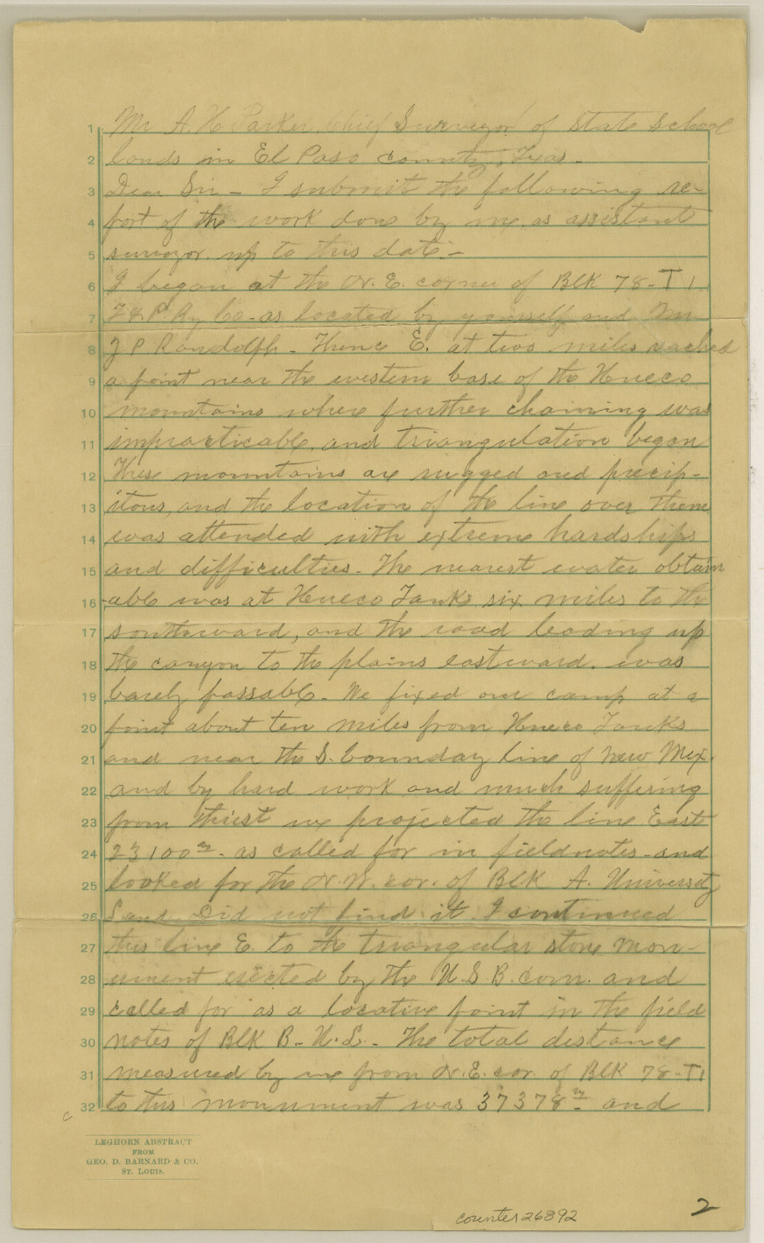
[A. S. Howren's report to A. H. Parker]
-
Map/Doc
26892
-
Collection
General Map Collection
-
Object Dates
6/27/1900 (Creation Date)
-
People and Organizations
A.S. Howren (Surveyor/Engineer)
A.H. Parker (Surveyor/Engineer)
J.P. Randolph (Surveyor/Engineer)
-
Counties
Hudspeth El Paso
-
Subjects
Surveying Sketch File
-
Height x Width
14.2 x 8.7 inches
36.1 x 22.1 cm
-
Medium
paper, manuscript
-
Features
Nueces Mountains
Hueco Tanks
Related maps
PSL Field Notes for Blocks 1, 5, 6, and 7 in El Paso County and Blocks 2, 3, 4, 8, 9, 10, 11, 12, 13, and 14 in Hudspeth County

PSL Field Notes for Blocks 1, 5, 6, and 7 in El Paso County and Blocks 2, 3, 4, 8, 9, 10, 11, 12, 13, and 14 in Hudspeth County
Map/Doc 81653
PSL Field Notes for Blocks 15 through 29 in Hudspeth County

PSL Field Notes for Blocks 15 through 29 in Hudspeth County
Map/Doc 81659
PSF Field Notes for Blocks 42 1/2 and 43 in Culberson and Hudspeth Counties, and Blocks 30 through 41 in Hudspeth County

PSF Field Notes for Blocks 42 1/2 and 43 in Culberson and Hudspeth Counties, and Blocks 30 through 41 in Hudspeth County
Map/Doc 81660
PSL Field Notes for Block 54 1/2 in Culberson and Hudspeth Counties, and Blocks 44, 45 1/2, 46, 47 1/2, 48, 49, 50, 51, 52 1/2, 53 1/2, 55 1/2, 56, and 57 in Hudspeth County

PSL Field Notes for Block 54 1/2 in Culberson and Hudspeth Counties, and Blocks 44, 45 1/2, 46, 47 1/2, 48, 49, 50, 51, 52 1/2, 53 1/2, 55 1/2, 56, and 57 in Hudspeth County
Map/Doc 81661
PSL Field Notes for Blocks 58, 59, 60 1/2, 61 1/2, 62 1/2, 63 1/2, 64 1/2, 65 1/2, 66 1/2, 67 1/2, 68 1/2, 69 1/2, 70, 71, and 72 in Hudspeth County

PSL Field Notes for Blocks 58, 59, 60 1/2, 61 1/2, 62 1/2, 63 1/2, 64 1/2, 65 1/2, 66 1/2, 67 1/2, 68 1/2, 69 1/2, 70, 71, and 72 in Hudspeth County
Map/Doc 81662
PSL Field Notes for Blocks 77 through 86 in Culberson County and Blocks 73 through 76 in Hudspeth County

PSL Field Notes for Blocks 77 through 86 in Culberson County and Blocks 73 through 76 in Hudspeth County
Map/Doc 81663
PSL Field Notes for Blocks 87 through 98 in Culberson County

PSL Field Notes for Blocks 87 through 98 in Culberson County
Map/Doc 81664
PSL Field Notes for Blocks 99, 100, 101, 103, 104, 105, 106, 107, 108, and 109 in Culberson County

PSL Field Notes for Blocks 99, 100, 101, 103, 104, 105, 106, 107, 108, and 109 in Culberson County
Map/Doc 81665
PSL Field Notes for Blocks 110 through 122 in Culberson County and Block 123 in Hudspeth County

PSL Field Notes for Blocks 110 through 122 in Culberson County and Block 123 in Hudspeth County
Map/Doc 81666
Part of: General Map Collection
Dawson County Boundary File 3 (2)

Print $40.00
- Digital $50.00
Dawson County Boundary File 3 (2)
Size 13.2 x 33.5 inches
Map/Doc 52367
Randall County Boundary File 1

Print $26.00
- Digital $50.00
Randall County Boundary File 1
Size 14.0 x 8.5 inches
Map/Doc 58098
Lavaca County Sketch File 22

Print $28.00
- Digital $50.00
Lavaca County Sketch File 22
1959
Size 14.2 x 8.7 inches
Map/Doc 29654
Real County Working Sketch 28

Print $20.00
- Digital $50.00
Real County Working Sketch 28
1947
Size 15.7 x 28.3 inches
Map/Doc 71920
Hale County Rolled Sketch 10

Print $40.00
- Digital $50.00
Hale County Rolled Sketch 10
Size 52.8 x 56.6 inches
Map/Doc 9096
Hamilton County Working Sketch 15

Print $40.00
- Digital $50.00
Hamilton County Working Sketch 15
1949
Size 54.5 x 37.6 inches
Map/Doc 63353
Flight Mission No. DCL-6C, Frame 4, Kenedy County

Print $20.00
- Digital $50.00
Flight Mission No. DCL-6C, Frame 4, Kenedy County
1943
Size 18.7 x 22.3 inches
Map/Doc 85864
Jefferson County Sketch File 48

Print $20.00
- Digital $50.00
Jefferson County Sketch File 48
1875
Size 19.8 x 21.0 inches
Map/Doc 11882
Limestone County Working Sketch 20

Print $20.00
- Digital $50.00
Limestone County Working Sketch 20
1976
Size 41.5 x 42.3 inches
Map/Doc 70570
Right of Way and Track Map of The Missouri, Kansas & Texas Railway of Texas

Print $40.00
- Digital $50.00
Right of Way and Track Map of The Missouri, Kansas & Texas Railway of Texas
1918
Size 25.6 x 52.6 inches
Map/Doc 64525
Coast Chart No. 210 Aransas Pass and Corpus Christi Bay with the coast to latitude 27° 12' Texas

Print $20.00
- Digital $50.00
Coast Chart No. 210 Aransas Pass and Corpus Christi Bay with the coast to latitude 27° 12' Texas
1913
Size 27.6 x 18.2 inches
Map/Doc 72807
Brewster County Sketch File N-21

Print $40.00
- Digital $50.00
Brewster County Sketch File N-21
1951
Size 18.0 x 18.6 inches
Map/Doc 10968
You may also like
Matagorda Bay and Approaches

Print $20.00
- Digital $50.00
Matagorda Bay and Approaches
1957
Size 35.1 x 44.8 inches
Map/Doc 73381

Aransas County Boundary File 1

Print $14.00
- Digital $50.00
Aransas County Boundary File 1
Size 14.2 x 8.6 inches
Map/Doc 49774
City of Lubbock, Lubbock County, Texas

Print $40.00
- Digital $50.00
City of Lubbock, Lubbock County, Texas
1946
Size 54.3 x 39.1 inches
Map/Doc 89902

Coleman County Sketch File 41

Print $32.00
- Digital $50.00
Coleman County Sketch File 41
Size 12.8 x 8.4 inches
Map/Doc 18748
Matagorda County Working Sketch 27

Print $20.00
- Digital $50.00
Matagorda County Working Sketch 27
1979
Size 19.0 x 14.3 inches
Map/Doc 70885
Aransas County Rolled Sketch 15A

Print $20.00
- Digital $50.00
Aransas County Rolled Sketch 15A
1969
Size 26.3 x 25.4 inches
Map/Doc 8411
Red River County Working Sketch 7

Print $20.00
- Digital $50.00
Red River County Working Sketch 7
1919
Size 25.0 x 24.1 inches
Map/Doc 71990
Edwards County Working Sketch 63

Print $20.00
- Digital $50.00
Edwards County Working Sketch 63
1955
Size 32.5 x 46.4 inches
Map/Doc 68939
Brewster County Working Sketch 86

Print $20.00
- Digital $50.00
Brewster County Working Sketch 86
1973
Size 27.6 x 27.7 inches
Map/Doc 67686
