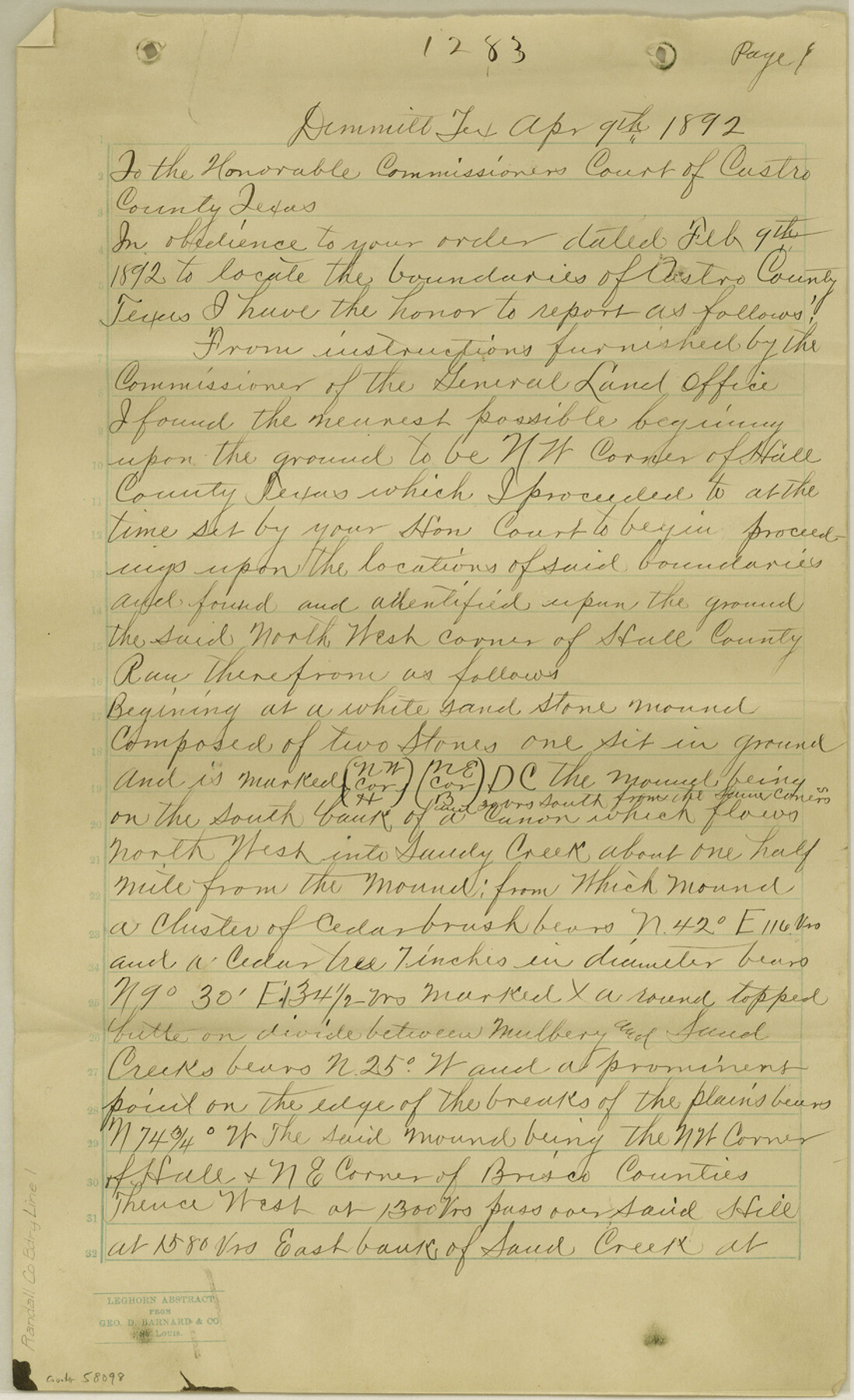
Randall County Boundary File 1
Fieldnotes of the South line of Randall Co. including connecting line from the corner of Hall Co.
-
Map/Doc
58098
-
Collection
General Map Collection
-
Counties
Randall
-
Subjects
County Boundaries
-
Height x Width
14.0 x 8.5 inches
35.6 x 21.6 cm
Part of: General Map Collection
United States - Gulf Coast - Galveston to Rio Grande

Print $20.00
- Digital $50.00
United States - Gulf Coast - Galveston to Rio Grande
1941
Size 27.2 x 18.2 inches
Map/Doc 72753
Newton County Sketch File 16

Print $5.00
- Digital $50.00
Newton County Sketch File 16
1880
Size 8.9 x 10.6 inches
Map/Doc 32390
Hays County Working Sketch 15

Print $40.00
- Digital $50.00
Hays County Working Sketch 15
1965
Size 39.8 x 51.6 inches
Map/Doc 66089
Midland County Working Sketch Graphic Index

Print $20.00
- Digital $50.00
Midland County Working Sketch Graphic Index
1930
Size 43.3 x 35.3 inches
Map/Doc 76641
Concho County

Print $20.00
- Digital $50.00
Concho County
1897
Size 45.9 x 38.0 inches
Map/Doc 66785
Hunt County Boundary File 49

Print $44.00
- Digital $50.00
Hunt County Boundary File 49
Size 9.1 x 5.2 inches
Map/Doc 55279
La Salle County Rolled Sketch 16

Print $20.00
- Digital $50.00
La Salle County Rolled Sketch 16
1948
Size 26.7 x 20.9 inches
Map/Doc 6580
Pecos County Boundary File 2

Print $38.00
- Digital $50.00
Pecos County Boundary File 2
Size 11.2 x 8.7 inches
Map/Doc 57871

Cameron County Rolled Sketch 23

Print $17.00
- Digital $50.00
Cameron County Rolled Sketch 23
Size 10.0 x 15.2 inches
Map/Doc 43931
Webb County Rolled Sketch 44

Print $20.00
- Digital $50.00
Webb County Rolled Sketch 44
1941
Size 23.9 x 20.1 inches
Map/Doc 8199
Map of Val Verde County

Print $40.00
- Digital $50.00
Map of Val Verde County
1898
Size 80.4 x 70.4 inches
Map/Doc 82014
You may also like
Jeff Davis County Sketch File 15

Print $20.00
- Digital $50.00
Jeff Davis County Sketch File 15
1883
Size 28.5 x 18.9 inches
Map/Doc 11859
Starr County Working Sketch 14

Print $20.00
- Digital $50.00
Starr County Working Sketch 14
1952
Size 23.4 x 20.9 inches
Map/Doc 63930
Flight Mission No. DQN-3K, Frame 9, Calhoun County

Print $20.00
- Digital $50.00
Flight Mission No. DQN-3K, Frame 9, Calhoun County
1953
Size 18.6 x 22.2 inches
Map/Doc 84341
Dimmit County Boundary File 5

Print $6.00
- Digital $50.00
Dimmit County Boundary File 5
Size 11.1 x 8.6 inches
Map/Doc 52577
Morris County Rolled Sketch 2

Print $40.00
- Digital $50.00
Morris County Rolled Sketch 2
1944
Size 59.4 x 43.5 inches
Map/Doc 9550
Presidio County Working Sketch 111

Print $20.00
- Digital $50.00
Presidio County Working Sketch 111
1981
Size 17.1 x 20.4 inches
Map/Doc 71788
Aransas County Boundary File 4

Print $30.00
- Digital $50.00
Aransas County Boundary File 4
Size 9.2 x 7.8 inches
Map/Doc 49790
[H. & T. C. RR. Company, Block 47, Sections 16- 28]
![91248, [H. & T. C. RR. Company, Block 47, Sections 16- 28], Twichell Survey Records](https://historictexasmaps.com/wmedia_w700/maps/91248-1.tif.jpg)
Print $20.00
- Digital $50.00
[H. & T. C. RR. Company, Block 47, Sections 16- 28]
Size 30.4 x 21.6 inches
Map/Doc 91248
Hardin County Sketch File 11

Print $8.00
- Digital $50.00
Hardin County Sketch File 11
Size 5.2 x 8.2 inches
Map/Doc 25112
Karnes County Sketch File 7

Print $10.00
- Digital $50.00
Karnes County Sketch File 7
1863
Size 10.6 x 8.2 inches
Map/Doc 28559
Nueces County Rolled Sketch 49

Print $20.00
- Digital $50.00
Nueces County Rolled Sketch 49
1941
Size 34.9 x 28.8 inches
Map/Doc 6889
