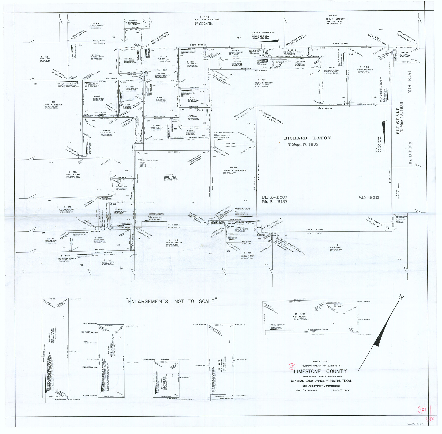
Limestone County Working Sketch 20
-
Map/Doc
70570
-
Collection
General Map Collection
-
Object Dates
2/17/1976 (Creation Date)
-
People and Organizations
Rosendo V. Molina (Draftsman)
-
Counties
Limestone
-
Subjects
Surveying Working Sketch
-
Height x Width
41.5 x 42.3 inches
105.4 x 107.4 cm
-
Scale
1" = 400 varas
Part of: General Map Collection
Outer Continental Shelf Leasing Maps (Texas Offshore Operations)

Print $20.00
- Digital $50.00
Outer Continental Shelf Leasing Maps (Texas Offshore Operations)
1954
Size 20.3 x 15.5 inches
Map/Doc 75839
Kerr County Rolled Sketch 11

Print $20.00
- Digital $50.00
Kerr County Rolled Sketch 11
1950
Size 28.1 x 36.9 inches
Map/Doc 6495
Flight Mission No. CRC-2R, Frame 64, Chambers County

Print $20.00
- Digital $50.00
Flight Mission No. CRC-2R, Frame 64, Chambers County
1956
Size 18.7 x 22.5 inches
Map/Doc 84735
Pecos County Rolled Sketch 167

Print $20.00
- Digital $50.00
Pecos County Rolled Sketch 167
1886
Size 41.1 x 27.1 inches
Map/Doc 7291
Crockett County Rolled Sketch 83

Print $20.00
- Digital $50.00
Crockett County Rolled Sketch 83
1960
Size 22.6 x 15.2 inches
Map/Doc 5623
Dimmit County Sketch File 10

Print $20.00
- Digital $50.00
Dimmit County Sketch File 10
Size 23.5 x 22.6 inches
Map/Doc 11338
Medina County Working Sketch 28

Print $20.00
- Digital $50.00
Medina County Working Sketch 28
1988
Size 32.1 x 35.3 inches
Map/Doc 70943
Map of Hidalgo County

Print $20.00
- Digital $50.00
Map of Hidalgo County
1896
Size 44.9 x 25.5 inches
Map/Doc 4684
Archer County Sketch File 11

Print $4.00
- Digital $50.00
Archer County Sketch File 11
Size 10.4 x 8.5 inches
Map/Doc 13644
Fisher County Working Sketch 5

Print $20.00
- Digital $50.00
Fisher County Working Sketch 5
1926
Size 23.0 x 25.6 inches
Map/Doc 69139
Bee County Sketch File 12

Print $4.00
- Digital $50.00
Bee County Sketch File 12
1876
Size 8.2 x 9.8 inches
Map/Doc 14293
Presidio County Working Sketch 42

Print $40.00
- Digital $50.00
Presidio County Working Sketch 42
1948
Size 90.9 x 38.2 inches
Map/Doc 71719
You may also like
Montgomery County Working Sketch 27

Print $20.00
- Digital $50.00
Montgomery County Working Sketch 27
1942
Size 42.1 x 33.4 inches
Map/Doc 71134
Working Sketch in Collingsworth County

Print $20.00
- Digital $50.00
Working Sketch in Collingsworth County
1910
Size 6.5 x 38.9 inches
Map/Doc 90728
Trinity County Working Sketch 2

Print $20.00
- Digital $50.00
Trinity County Working Sketch 2
1905
Size 16.7 x 13.6 inches
Map/Doc 69450
Crockett County Working Sketch 96

Print $20.00
- Digital $50.00
Crockett County Working Sketch 96
1979
Size 25.5 x 16.9 inches
Map/Doc 68429

Ellis County Working Sketch Graphic Index

Print $20.00
- Digital $50.00
Ellis County Working Sketch Graphic Index
1943
Size 43.1 x 47.7 inches
Map/Doc 76535
Outer Continental Shelf Leasing Maps (Texas Offshore Operations)

Print $20.00
- Digital $50.00
Outer Continental Shelf Leasing Maps (Texas Offshore Operations)
Size 17.0 x 18.4 inches
Map/Doc 75847
Taylor County Sketch File 18

Print $6.00
- Digital $50.00
Taylor County Sketch File 18
Size 11.6 x 7.3 inches
Map/Doc 37813
Pecos County Sketch File 74

Print $8.00
- Digital $50.00
Pecos County Sketch File 74
1941
Size 14.1 x 8.8 inches
Map/Doc 33900
[Surveys around the Martha Barker survey]
![90235, [Surveys around the Martha Barker survey], Twichell Survey Records](https://historictexasmaps.com/wmedia_w700/maps/90235-1.tif.jpg)
Print $20.00
- Digital $50.00
[Surveys around the Martha Barker survey]
Size 26.8 x 20.2 inches
Map/Doc 90235
Kimble County Sketch File 35

Print $16.00
- Digital $50.00
Kimble County Sketch File 35
1963
Size 11.2 x 8.7 inches
Map/Doc 28982
Yoakum County Sketch File 9

Print $20.00
- Digital $50.00
Yoakum County Sketch File 9
Size 14.1 x 8.9 inches
Map/Doc 40753