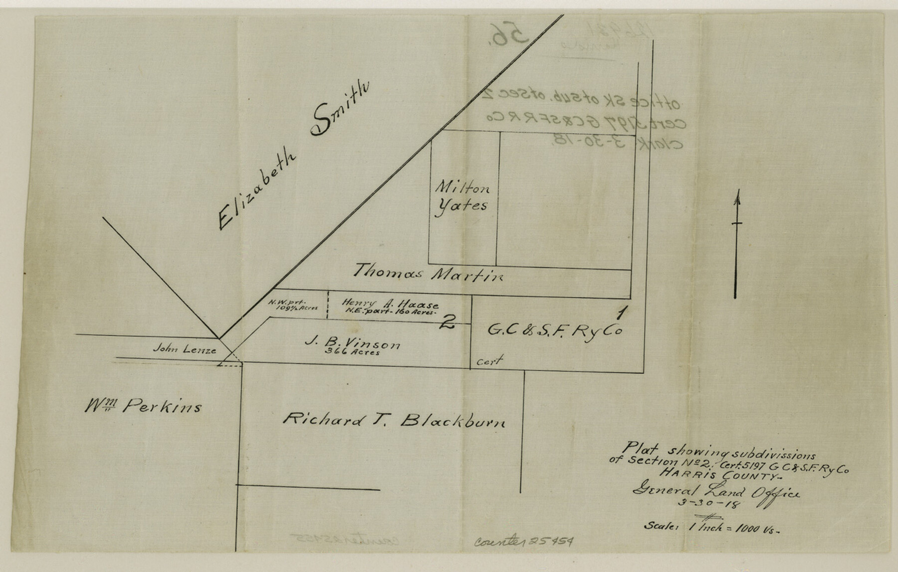
Harris County Sketch File 56
Plat showing subdivisions of section no. 2, certificate 5197, G. C. & S. F. RR. Co.]
-
Map/Doc
25454
-
Collection
General Map Collection
-
Object Dates
1918/3/30 (Creation Date)
-
People and Organizations
Clark (Surveyor/Engineer)
-
Counties
Harris
-
Subjects
Surveying Sketch File
-
Height x Width
8.2 x 12.8 inches
20.8 x 32.5 cm
-
Medium
paper, manuscript
-
Scale
1" = 1000 varas
Part of: General Map Collection

Aransas County Working Sketch 1

Print $20.00
- Digital $50.00
Aransas County Working Sketch 1
1919
Size 13.8 x 27.5 inches
Map/Doc 67168
Edwards County Working Sketch 7

Print $20.00
- Digital $50.00
Edwards County Working Sketch 7
1918
Size 34.6 x 29.7 inches
Map/Doc 68883
Webb County Working Sketch 32

Print $20.00
- Digital $50.00
Webb County Working Sketch 32
1937
Size 34.5 x 36.0 inches
Map/Doc 72397
Map of Falls County

Print $20.00
- Digital $50.00
Map of Falls County
1855
Size 21.4 x 23.9 inches
Map/Doc 3532
San Patricio County Sketch File 37

Print $94.00
- Digital $50.00
San Patricio County Sketch File 37
1915
Size 10.5 x 6.4 inches
Map/Doc 36142
Flight Mission No. DAG-19K, Frame 60, Matagorda County

Print $20.00
- Digital $50.00
Flight Mission No. DAG-19K, Frame 60, Matagorda County
1952
Size 18.6 x 22.2 inches
Map/Doc 86387
Flight Mission No. BRE-2P, Frame 108, Nueces County

Print $20.00
- Digital $50.00
Flight Mission No. BRE-2P, Frame 108, Nueces County
1956
Size 18.5 x 22.5 inches
Map/Doc 86793
Jasper County Boundary File 1

Print $50.00
- Digital $50.00
Jasper County Boundary File 1
Size 12.6 x 20.5 inches
Map/Doc 55462
Map of Motley County

Print $20.00
- Digital $50.00
Map of Motley County
1902
Size 43.4 x 37.7 inches
Map/Doc 10799
Flight Mission No. CGI-3N, Frame 148, Cameron County

Print $20.00
- Digital $50.00
Flight Mission No. CGI-3N, Frame 148, Cameron County
1954
Size 18.5 x 22.2 inches
Map/Doc 84621
Jackson County Rolled Sketch 9

Print $40.00
- Digital $50.00
Jackson County Rolled Sketch 9
1941
Size 50.7 x 32.1 inches
Map/Doc 9258
You may also like
Winkler County Working Sketch 13

Print $20.00
- Digital $50.00
Winkler County Working Sketch 13
1961
Size 39.2 x 41.2 inches
Map/Doc 72607
Flight Mission No. CRK-5P, Frame 153, Refugio County

Print $20.00
- Digital $50.00
Flight Mission No. CRK-5P, Frame 153, Refugio County
1956
Size 18.4 x 22.3 inches
Map/Doc 86934
Flight Mission No. DAG-23K, Frame 19, Matagorda County

Print $20.00
- Digital $50.00
Flight Mission No. DAG-23K, Frame 19, Matagorda County
1953
Size 18.5 x 22.2 inches
Map/Doc 86481
[Blocks J, L, and Wilson County School Land]
![91277, [Blocks J, L, and Wilson County School Land], Twichell Survey Records](https://historictexasmaps.com/wmedia_w700/maps/91277-1.tif.jpg)
Print $20.00
- Digital $50.00
[Blocks J, L, and Wilson County School Land]
Size 15.8 x 20.4 inches
Map/Doc 91277
Galveston/Galveston Island, Texas

Galveston/Galveston Island, Texas
Size 18.4 x 24.2 inches
Map/Doc 94345
Railroad Track Map, H&TCRRCo., Falls County, Texas

Print $4.00
- Digital $50.00
Railroad Track Map, H&TCRRCo., Falls County, Texas
1918
Size 11.6 x 18.6 inches
Map/Doc 62848
Jones County Working Sketch 3

Print $20.00
- Digital $50.00
Jones County Working Sketch 3
1938
Size 28.7 x 25.4 inches
Map/Doc 66641
Texas, Matagorda Bay, Port O'Connor to Gallinipper Point

Print $40.00
- Digital $50.00
Texas, Matagorda Bay, Port O'Connor to Gallinipper Point
1933
Size 31.1 x 48.6 inches
Map/Doc 69985
[Surveys in Austin's Colony along New Year's Creek and the Navidad River]
![212, [Surveys in Austin's Colony along New Year's Creek and the Navidad River], General Map Collection](https://historictexasmaps.com/wmedia_w700/maps/212.tif.jpg)
Print $20.00
- Digital $50.00
[Surveys in Austin's Colony along New Year's Creek and the Navidad River]
Size 20.2 x 15.6 inches
Map/Doc 212
Flight Mission No. BRA-8M, Frame 123, Jefferson County

Print $20.00
- Digital $50.00
Flight Mission No. BRA-8M, Frame 123, Jefferson County
1953
Size 18.7 x 22.3 inches
Map/Doc 85619
[Map of Resurvey of Block 34 and 35, Township 5 N]
![90551, [Map of Resurvey of Block 34 and 35, Township 5 N], Twichell Survey Records](https://historictexasmaps.com/wmedia_w700/maps/90551-1.tif.jpg)
Print $20.00
- Digital $50.00
[Map of Resurvey of Block 34 and 35, Township 5 N]
1915
Size 25.5 x 16.4 inches
Map/Doc 90551
Crockett County Sketch File 75

Print $20.00
- Digital $50.00
Crockett County Sketch File 75
Size 26.3 x 28.8 inches
Map/Doc 11234