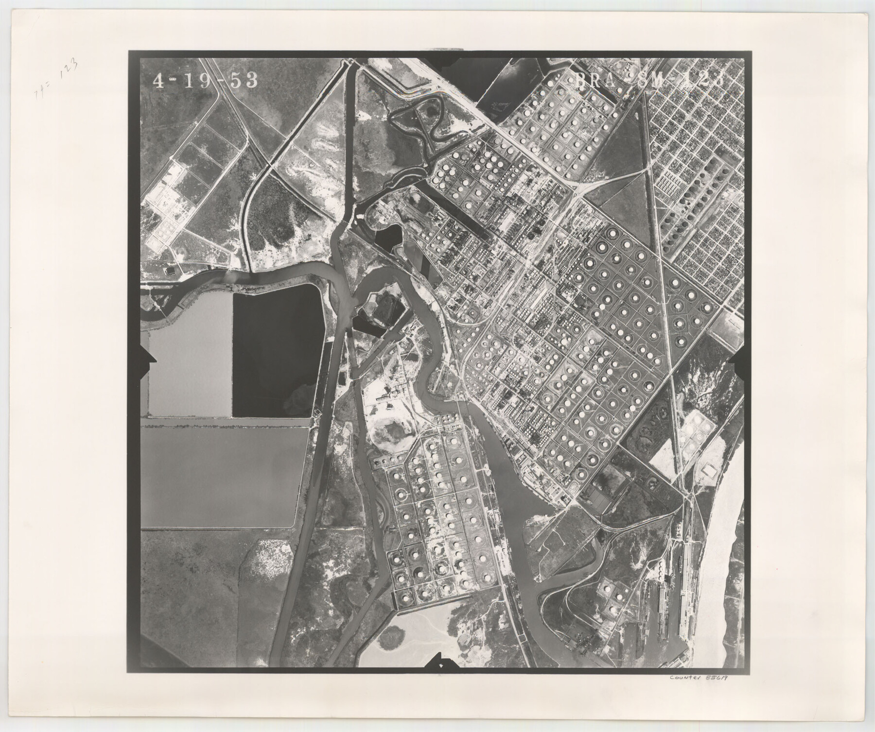
Flight Mission No. BRA-8M, Frame 123, Jefferson County
BRA-8M-123
-
Map/Doc
85619
-
Collection
General Map Collection
-
Object Dates
1953/4/19 (Creation Date)
-
People and Organizations
U. S. Department of Agriculture (Publisher)
-
Counties
Jefferson
-
Subjects
Aerial Photograph
-
Height x Width
18.7 x 22.3 inches
47.5 x 56.6 cm
-
Comments
Flown by Jack Ammann Photogrammetric Engineers of San Antonio, Texas.
Part of: General Map Collection
Nacogdoches County Sketch File 18

Print $4.00
- Digital $50.00
Nacogdoches County Sketch File 18
1846
Size 6.0 x 9.4 inches
Map/Doc 32268
Harris County Sketch File 85

Print $20.00
- Digital $50.00
Harris County Sketch File 85
1894
Size 35.7 x 26.0 inches
Map/Doc 11673
Pecos County Rolled Sketch 167

Print $20.00
- Digital $50.00
Pecos County Rolled Sketch 167
1886
Size 41.1 x 27.1 inches
Map/Doc 7291
Flight Mission No. DIX-6P, Frame 119, Aransas County

Print $20.00
- Digital $50.00
Flight Mission No. DIX-6P, Frame 119, Aransas County
1956
Size 19.1 x 22.7 inches
Map/Doc 83825


Liberty County Working Sketch 72

Print $20.00
- Digital $50.00
Liberty County Working Sketch 72
1977
Size 25.8 x 28.7 inches
Map/Doc 70532
Flight Mission No. CUG-1P, Frame 23, Kleberg County

Print $20.00
- Digital $50.00
Flight Mission No. CUG-1P, Frame 23, Kleberg County
1956
Size 18.5 x 22.1 inches
Map/Doc 86113
Victoria County Sketch File 4

Print $7.00
- Digital $50.00
Victoria County Sketch File 4
1876
Size 10.1 x 8.2 inches
Map/Doc 39517
[Surveys in the Liberty District]
![273, [Surveys in the Liberty District], General Map Collection](https://historictexasmaps.com/wmedia_w700/maps/273.tif.jpg)
Print $2.00
- Digital $50.00
[Surveys in the Liberty District]
1841
Size 7.0 x 10.7 inches
Map/Doc 273
Guadalupe River, Watershed [of the Guadalupe River]
![65059, Guadalupe River, Watershed [of the Guadalupe River], General Map Collection](https://historictexasmaps.com/wmedia_w700/maps/65059-GC.tif.jpg)
Print $6.00
- Digital $50.00
Guadalupe River, Watershed [of the Guadalupe River]
1925
Size 30.1 x 33.4 inches
Map/Doc 65059
Gonzales County Sketch File 2

Print $10.00
- Digital $50.00
Gonzales County Sketch File 2
Size 8.9 x 7.8 inches
Map/Doc 24357
You may also like
Delta County Sketch File 2

Print $4.00
- Digital $50.00
Delta County Sketch File 2
1871
Size 8.4 x 13.2 inches
Map/Doc 20670
United States Gulf Coast - from Galveston to the Rio Grande

Print $20.00
- Digital $50.00
United States Gulf Coast - from Galveston to the Rio Grande
1915
Size 26.4 x 18.2 inches
Map/Doc 72733
Starr County Working Sketch 9

Print $20.00
- Digital $50.00
Starr County Working Sketch 9
1940
Size 41.5 x 21.4 inches
Map/Doc 63925
Flight Mission No. BQY-4M, Frame 35, Harris County

Print $20.00
- Digital $50.00
Flight Mission No. BQY-4M, Frame 35, Harris County
1953
Size 18.7 x 22.5 inches
Map/Doc 85250
Refugio County Sketch File 6

Print $4.00
- Digital $50.00
Refugio County Sketch File 6
1856
Size 8.0 x 13.7 inches
Map/Doc 35249
Presidio County Rolled Sketch S

Print $20.00
- Digital $50.00
Presidio County Rolled Sketch S
1915
Size 15.6 x 15.4 inches
Map/Doc 7413
[Cotton Belt] St. Louis Arkansas & Texas R'y, Lufkin Branch, Formely the Kansas & Gulf Short Line
![64371, [Cotton Belt] St. Louis Arkansas & Texas R'y, Lufkin Branch, Formely the Kansas & Gulf Short Line, General Map Collection](https://historictexasmaps.com/wmedia_w700/maps/64371.tif.jpg)
Print $20.00
- Digital $50.00
[Cotton Belt] St. Louis Arkansas & Texas R'y, Lufkin Branch, Formely the Kansas & Gulf Short Line
1888
Size 11.2 x 39.5 inches
Map/Doc 64371
Colton's new map of the state of Texas, the Indian Territory and adjoining portions of New Mexico, Louisiana, and Arkansas

Print $20.00
Colton's new map of the state of Texas, the Indian Territory and adjoining portions of New Mexico, Louisiana, and Arkansas
1872
Size 31.1 x 36.6 inches
Map/Doc 93579
Henderson County Sketch File 14

Print $4.00
- Digital $50.00
Henderson County Sketch File 14
1889
Size 10.7 x 7.3 inches
Map/Doc 26355
Sabine County Working Sketch 16

Print $20.00
- Digital $50.00
Sabine County Working Sketch 16
1984
Size 26.0 x 29.8 inches
Map/Doc 63687
[Index map of T. & P. Ry. Company’s 80-mile Trans-Pecos Reserve’s perpetuated corners - South Part]
![69766, [Index map of T. & P. Ry. Company’s 80-mile Trans-Pecos Reserve’s perpetuated corners - South Part], General Map Collection](https://historictexasmaps.com/wmedia_w700/maps/69766.tif.jpg)
Print $40.00
- Digital $50.00
[Index map of T. & P. Ry. Company’s 80-mile Trans-Pecos Reserve’s perpetuated corners - South Part]
Size 23.1 x 90.1 inches
Map/Doc 69766
Hood County Sketch File 10

Print $20.00
- Digital $50.00
Hood County Sketch File 10
Size 20.6 x 22.9 inches
Map/Doc 11778