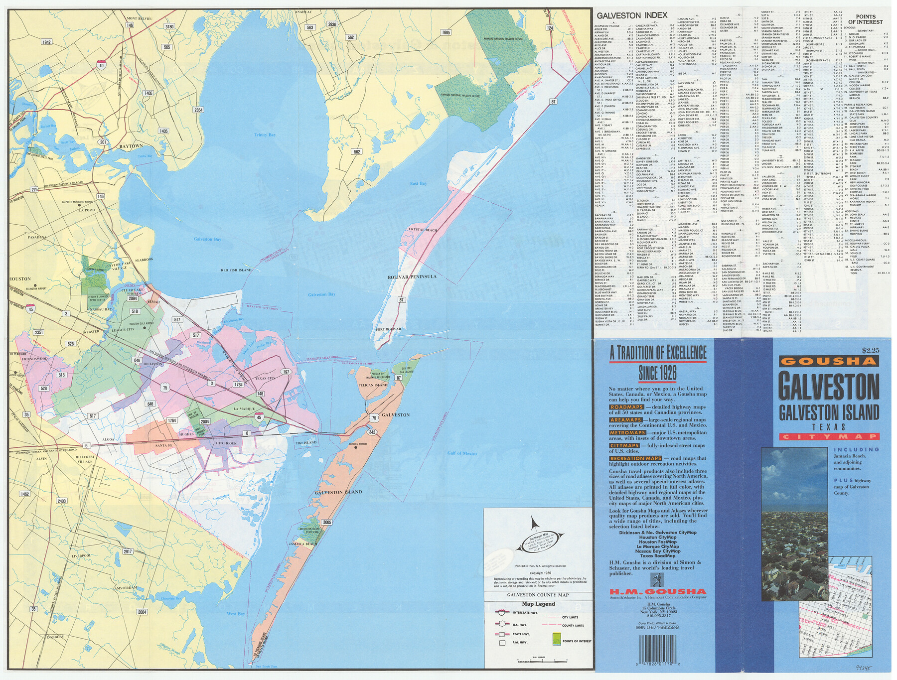
Galveston/Galveston Island, Texas
[Recto - Map of Galveston County]
-
Map/Doc
94345
-
Collection
General Map Collection
-
Object Dates
1989 (Edition Date)
-
People and Organizations
H.M. Gousha (Publisher)
-
Counties
Galveston
-
Subjects
County
-
Height x Width
18.4 x 24.2 inches
46.7 x 61.5 cm
-
Medium
paper, etching/engraving/lithograph
-
Comments
For maps of Galveston and Galveston Island on verso, see 94346. For research only.
Related maps
Galveston/Galveston Island, Texas

Galveston/Galveston Island, Texas
Size 18.4 x 24.3 inches
Map/Doc 94346
Part of: General Map Collection
Uvalde County Working Sketch 40

Print $20.00
- Digital $50.00
Uvalde County Working Sketch 40
1975
Size 21.2 x 19.6 inches
Map/Doc 72110
[Surveys in the Bexar District along the Colorado River]
![38, [Surveys in the Bexar District along the Colorado River], General Map Collection](https://historictexasmaps.com/wmedia_w700/maps/38.tif.jpg)
Print $2.00
- Digital $50.00
[Surveys in the Bexar District along the Colorado River]
1841
Size 7.2 x 9.1 inches
Map/Doc 38
[Sketch for Mineral Application 24072, San Jacinto River]
![65606, [Sketch for Mineral Application 24072, San Jacinto River], General Map Collection](https://historictexasmaps.com/wmedia_w700/maps/65606.tif.jpg)
Print $20.00
- Digital $50.00
[Sketch for Mineral Application 24072, San Jacinto River]
1929
Size 23.2 x 17.8 inches
Map/Doc 65606
Stonewall County Rolled Sketch 14

Print $20.00
- Digital $50.00
Stonewall County Rolled Sketch 14
1902
Size 32.9 x 25.2 inches
Map/Doc 7869
Starr County Working Sketch 28

Print $20.00
- Digital $50.00
Starr County Working Sketch 28
2004
Size 28.0 x 39.6 inches
Map/Doc 83010
Flight Mission No. CRC-4R, Frame 67, Chambers County

Print $20.00
- Digital $50.00
Flight Mission No. CRC-4R, Frame 67, Chambers County
1956
Size 18.8 x 22.5 inches
Map/Doc 84871
Lavaca County

Print $40.00
- Digital $50.00
Lavaca County
1946
Size 52.6 x 44.1 inches
Map/Doc 95566
Connected Map of Austin's Colony

Print $40.00
- Digital $50.00
Connected Map of Austin's Colony
1837
Size 90.6 x 80.9 inches
Map/Doc 1943
Pecos County Working Sketch 96

Print $20.00
- Digital $50.00
Pecos County Working Sketch 96
1970
Size 41.2 x 39.0 inches
Map/Doc 71569
Right of Way and Track Map, the Missouri, Kansas and Texas Ry. of Texas - Henrietta Division

Print $20.00
- Digital $50.00
Right of Way and Track Map, the Missouri, Kansas and Texas Ry. of Texas - Henrietta Division
1918
Size 11.8 x 26.8 inches
Map/Doc 64755
Matagorda County Rolled Sketch 37A

Print $40.00
- Digital $50.00
Matagorda County Rolled Sketch 37A
Size 48.7 x 41.1 inches
Map/Doc 10195
Right-of-Way and Track Map, Texas State Railroad operated by the T. and N. O. R.R. Co.

Print $40.00
- Digital $50.00
Right-of-Way and Track Map, Texas State Railroad operated by the T. and N. O. R.R. Co.
1917
Size 24.8 x 56.3 inches
Map/Doc 64173
You may also like
Madison County

Print $20.00
- Digital $50.00
Madison County
1871
Size 14.0 x 19.6 inches
Map/Doc 3833
Flight Mission No. DQN-5K, Frame 58, Calhoun County

Print $20.00
- Digital $50.00
Flight Mission No. DQN-5K, Frame 58, Calhoun County
1953
Size 15.5 x 15.3 inches
Map/Doc 84401
Kerr County Working Sketch 7

Print $20.00
- Digital $50.00
Kerr County Working Sketch 7
1947
Size 38.9 x 30.8 inches
Map/Doc 70038
Pecos County Working Sketch 36

Print $20.00
- Digital $50.00
Pecos County Working Sketch 36
1939
Size 47.4 x 38.8 inches
Map/Doc 71508
General Highway Map, Wilson County, Texas

Print $20.00
General Highway Map, Wilson County, Texas
1940
Size 18.2 x 24.8 inches
Map/Doc 79282
Eastland County Rolled Sketch 25

Print $20.00
- Digital $50.00
Eastland County Rolled Sketch 25
1990
Size 36.9 x 47.7 inches
Map/Doc 8831
Plat Compiled by W. J. Williams, Plainview, Texas, and Sylvan Sanders, Lubbock, Texas Showing Position of Original and Re-Survey Corners in Lynn, Terry, Yoakum, Gaines and Dawson Counties, Texas

Print $40.00
- Digital $50.00
Plat Compiled by W. J. Williams, Plainview, Texas, and Sylvan Sanders, Lubbock, Texas Showing Position of Original and Re-Survey Corners in Lynn, Terry, Yoakum, Gaines and Dawson Counties, Texas
1946
Size 57.6 x 22.9 inches
Map/Doc 89689
Coast of Texas and its defences

Print $20.00
- Digital $50.00
Coast of Texas and its defences
Size 27.6 x 18.2 inches
Map/Doc 72685
Map Showing the Route of the Arkansas Regiment from Shreveport La. To San Antonio de Bexar Texas

Print $20.00
- Digital $50.00
Map Showing the Route of the Arkansas Regiment from Shreveport La. To San Antonio de Bexar Texas
Size 12.5 x 19.5 inches
Map/Doc 94000
General Highway Map, Harris County, Texas

Print $20.00
General Highway Map, Harris County, Texas
1939
Size 25.3 x 18.7 inches
Map/Doc 79116
Harris County Working Sketch 117

Print $20.00
- Digital $50.00
Harris County Working Sketch 117
1984
Size 28.2 x 25.5 inches
Map/Doc 66009
Brooks County Working Sketch 9

Print $20.00
- Digital $50.00
Brooks County Working Sketch 9
1931
Size 25.7 x 38.7 inches
Map/Doc 67793