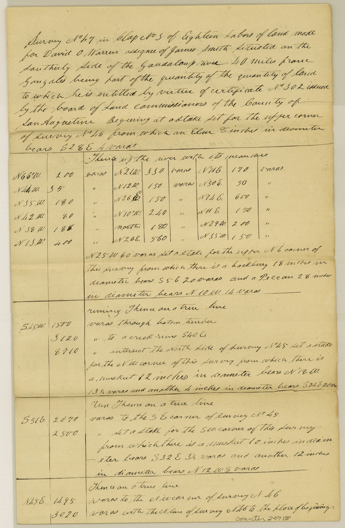
Guadalupe County Sketch File 24
[Field notes of survey no. 47 of 18 labors of land]
-
Map/Doc
24715
-
Collection
General Map Collection
-
Object Dates
1838/4/14 (Creation Date)
1984/11/27 (File Date)
-
People and Organizations
David O. Warren (Surveyor/Engineer)
-
Counties
Guadalupe San Augustine
-
Subjects
Surveying Sketch File
-
Height x Width
12.9 x 8.4 inches
32.8 x 21.3 cm
-
Medium
paper, manuscript
-
Features
Guadalupe River
Gonzales
Part of: General Map Collection
Terry County Sketch File 12

Print $20.00
- Digital $50.00
Terry County Sketch File 12
Size 10.9 x 43.2 inches
Map/Doc 10396
Ward County Working Sketch 19

Print $20.00
- Digital $50.00
Ward County Working Sketch 19
1949
Size 24.2 x 26.1 inches
Map/Doc 72325
Hale County Rolled Sketch 5

Print $20.00
- Digital $50.00
Hale County Rolled Sketch 5
1893
Size 29.0 x 22.2 inches
Map/Doc 9094
Val Verde County Working Sketch 80

Print $20.00
- Digital $50.00
Val Verde County Working Sketch 80
1973
Size 29.1 x 46.1 inches
Map/Doc 72215
Flight Mission No. BRA-7M, Frame 204, Jefferson County

Print $20.00
- Digital $50.00
Flight Mission No. BRA-7M, Frame 204, Jefferson County
1953
Size 18.6 x 22.3 inches
Map/Doc 85572
Carson County Boundary File 10

Print $2.00
- Digital $50.00
Carson County Boundary File 10
Size 11.5 x 7.2 inches
Map/Doc 51185

Karnes County Working Sketch 10

Print $20.00
- Digital $50.00
Karnes County Working Sketch 10
1970
Size 35.5 x 26.3 inches
Map/Doc 66658
Dimmit County Rolled Sketch 20A

Print $20.00
- Digital $50.00
Dimmit County Rolled Sketch 20A
1999
Size 24.9 x 36.5 inches
Map/Doc 6065
Zavala County Sketch File 49

Print $10.00
- Digital $50.00
Zavala County Sketch File 49
1955
Size 14.5 x 9.1 inches
Map/Doc 41441
Polk County Sketch File 6

Print $4.00
- Digital $50.00
Polk County Sketch File 6
Size 7.1 x 9.4 inches
Map/Doc 34129
Taylor County Working Sketch 11

Print $20.00
- Digital $50.00
Taylor County Working Sketch 11
1956
Size 23.0 x 24.4 inches
Map/Doc 69621
You may also like
General Highway Map, Shackelford County, Texas

Print $20.00
General Highway Map, Shackelford County, Texas
1940
Size 18.4 x 24.8 inches
Map/Doc 79241
Hardin County Working Sketch 11

Print $20.00
- Digital $50.00
Hardin County Working Sketch 11
1929
Size 25.4 x 24.1 inches
Map/Doc 63409
Gregg County Working Sketch 15

Print $20.00
- Digital $50.00
Gregg County Working Sketch 15
1941
Size 24.8 x 29.5 inches
Map/Doc 63282
Hays County Sketch File 27

Print $6.00
- Digital $50.00
Hays County Sketch File 27
Size 11.2 x 8.8 inches
Map/Doc 26252
Flight Mission No. CGI-4N, Frame 164, Cameron County

Print $20.00
- Digital $50.00
Flight Mission No. CGI-4N, Frame 164, Cameron County
1955
Size 18.6 x 22.3 inches
Map/Doc 84672
Donley County Working Sketch 5

Print $40.00
- Digital $50.00
Donley County Working Sketch 5
1957
Size 54.8 x 32.2 inches
Map/Doc 62185
Chambers County Sketch File X

Print $4.00
- Digital $50.00
Chambers County Sketch File X
1936
Size 11.1 x 8.7 inches
Map/Doc 17598

North Part Brewster Co.

Print $20.00
- Digital $50.00
North Part Brewster Co.
1904
Size 37.0 x 46.9 inches
Map/Doc 66727
Starr County Sketch File 39

Print $20.00
- Digital $50.00
Starr County Sketch File 39
1940
Size 22.9 x 22.1 inches
Map/Doc 12339
Plat of a survey on Padre Island in Willacy County surveyed for South Padre Development Corporation by Claunch and Associates

Print $40.00
- Digital $50.00
Plat of a survey on Padre Island in Willacy County surveyed for South Padre Development Corporation by Claunch and Associates
1973
Size 73.7 x 42.8 inches
Map/Doc 61426
Map of the chief part of the Southern States and part of the Western engraved to illustrate Mitchell's school and family geography

Print $20.00
- Digital $50.00
Map of the chief part of the Southern States and part of the Western engraved to illustrate Mitchell's school and family geography
1839
Size 11.8 x 17.5 inches
Map/Doc 93497