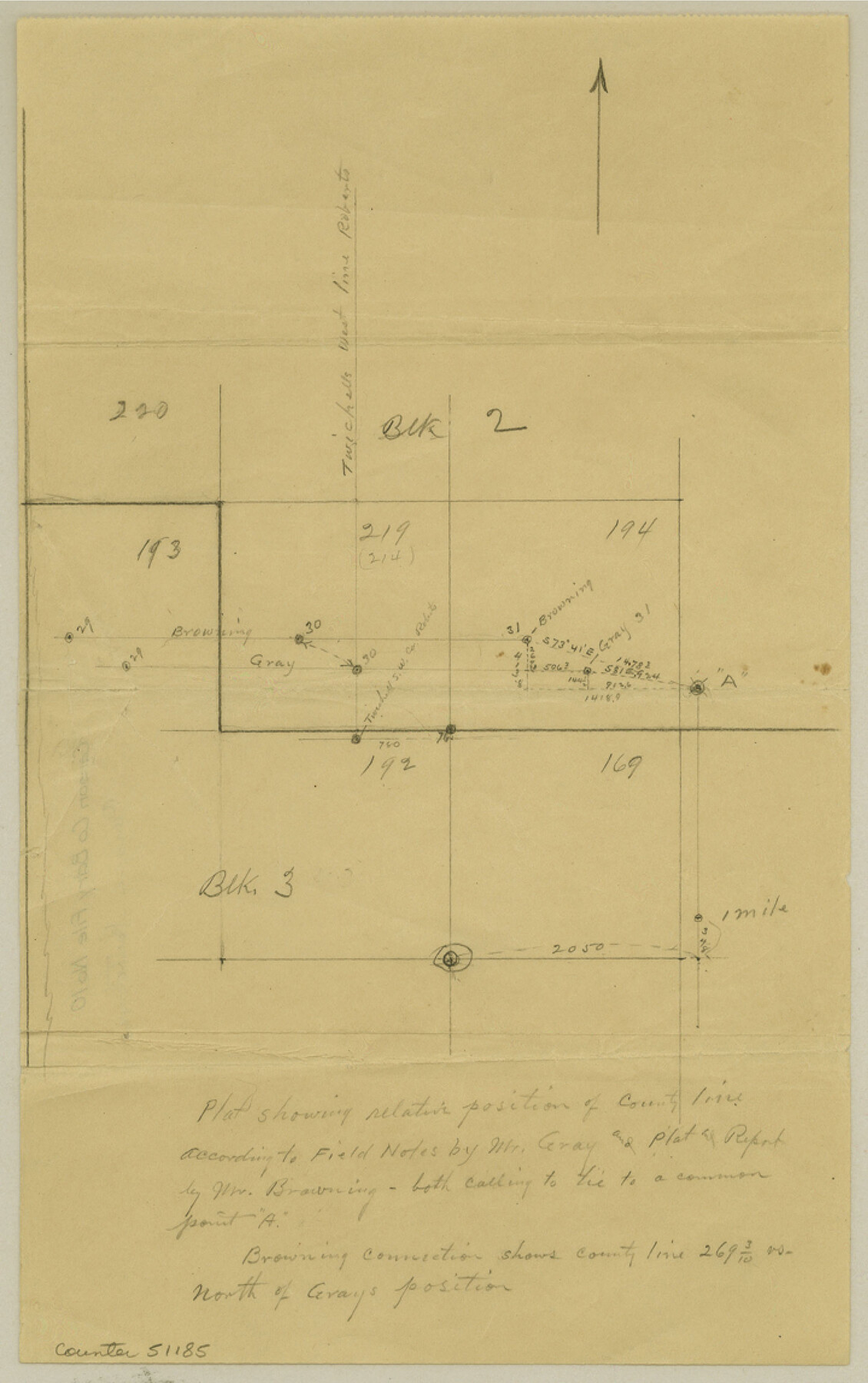
Carson County Boundary File 10
[Sketch of the relative position of the county line between Carson and Hutchinson counties]
-
Map/Doc
51185
-
Collection
General Map Collection
-
Counties
Carson
-
Subjects
County Boundaries
-
Height x Width
11.5 x 7.2 inches
29.2 x 18.3 cm
Part of: General Map Collection
Jack County Boundary File 3a

Print $50.00
- Digital $50.00
Jack County Boundary File 3a
Size 8.7 x 7.4 inches
Map/Doc 55413
Hall County Working Sketch 7

Print $20.00
- Digital $50.00
Hall County Working Sketch 7
1955
Size 31.6 x 18.2 inches
Map/Doc 63335
Wichita County Working Sketch 11

Print $20.00
- Digital $50.00
Wichita County Working Sketch 11
1920
Size 32.0 x 18.8 inches
Map/Doc 72520
Duval County Rolled Sketch 19

Print $4.00
- Digital $50.00
Duval County Rolled Sketch 19
1940
Size 20.2 x 15.1 inches
Map/Doc 5740
Jeff Davis County Working Sketch 25

Print $20.00
- Digital $50.00
Jeff Davis County Working Sketch 25
1959
Size 28.9 x 32.2 inches
Map/Doc 66520
Comal County Sketch File 2

Print $22.00
- Digital $50.00
Comal County Sketch File 2
1848
Size 13.7 x 13.3 inches
Map/Doc 18997
Wichita County Sketch File 33

Print $6.00
- Digital $50.00
Wichita County Sketch File 33
1949
Size 11.0 x 17.0 inches
Map/Doc 40152
Flight Mission No. DCL-7C, Frame 15, Kenedy County

Print $20.00
- Digital $50.00
Flight Mission No. DCL-7C, Frame 15, Kenedy County
1943
Size 15.4 x 15.3 inches
Map/Doc 86007
Matagorda County NRC Article 33.136 Sketch 18

Print $24.00
Matagorda County NRC Article 33.136 Sketch 18
2023
Map/Doc 97283
United States Atlantic and Gulf Coasts Including Puerto Rico and the Virgin Islands

Print $40.00
- Digital $50.00
United States Atlantic and Gulf Coasts Including Puerto Rico and the Virgin Islands
1989
Size 20.6 x 60.3 inches
Map/Doc 73553
Burnet County Sketch File 4a

Print $4.00
- Digital $50.00
Burnet County Sketch File 4a
1856
Size 12.3 x 8.2 inches
Map/Doc 16678
McMullen County Rolled Sketch 5

Print $20.00
- Digital $50.00
McMullen County Rolled Sketch 5
Size 46.4 x 26.8 inches
Map/Doc 6723
You may also like
Jefferson County NRC Article 33.136 Sketch 7

Print $24.00
- Digital $50.00
Jefferson County NRC Article 33.136 Sketch 7
2009
Size 30.8 x 43.0 inches
Map/Doc 94711
Jones County Working Sketch 8

Print $20.00
- Digital $50.00
Jones County Working Sketch 8
1979
Size 25.3 x 20.9 inches
Map/Doc 66646
Hutchinson County Rolled Sketch 42

Print $40.00
- Digital $50.00
Hutchinson County Rolled Sketch 42
1993
Size 38.0 x 49.6 inches
Map/Doc 6308
[Atlas C, Table of Contents]
![78353, [Atlas C, Table of Contents], General Map Collection](https://historictexasmaps.com/wmedia_w700/maps/78353.tif.jpg)
Print $3.00
- Digital $50.00
[Atlas C, Table of Contents]
Size 14.7 x 9.6 inches
Map/Doc 78353
Burleson County Working Sketch 34

Print $20.00
- Digital $50.00
Burleson County Working Sketch 34
1981
Size 20.0 x 12.2 inches
Map/Doc 67753
Nueces County Rolled Sketch 88

Print $20.00
- Digital $50.00
Nueces County Rolled Sketch 88
1983
Size 18.4 x 24.6 inches
Map/Doc 6990
Nautical Chart 887-SC Intracoastal Waterway - Galveston Bay to Cedar Lakes including the Brazos and San Bernard Rivers, Texas

Print $40.00
- Digital $50.00
Nautical Chart 887-SC Intracoastal Waterway - Galveston Bay to Cedar Lakes including the Brazos and San Bernard Rivers, Texas
1971
Size 15.3 x 59.6 inches
Map/Doc 69939

Culberson County Rolled Sketch 21

Print $20.00
- Digital $50.00
Culberson County Rolled Sketch 21
1915
Size 31.2 x 15.6 inches
Map/Doc 5654
Lee County Sketch File 1

Print $4.00
- Digital $50.00
Lee County Sketch File 1
1856
Size 13.1 x 8.2 inches
Map/Doc 29678
Flight Mission No. BRE-2P, Frame 34, Nueces County

Print $20.00
- Digital $50.00
Flight Mission No. BRE-2P, Frame 34, Nueces County
1956
Size 18.7 x 22.6 inches
Map/Doc 86736
Map of Harris County

Print $20.00
- Digital $50.00
Map of Harris County
1893
Size 29.7 x 33.8 inches
Map/Doc 3632