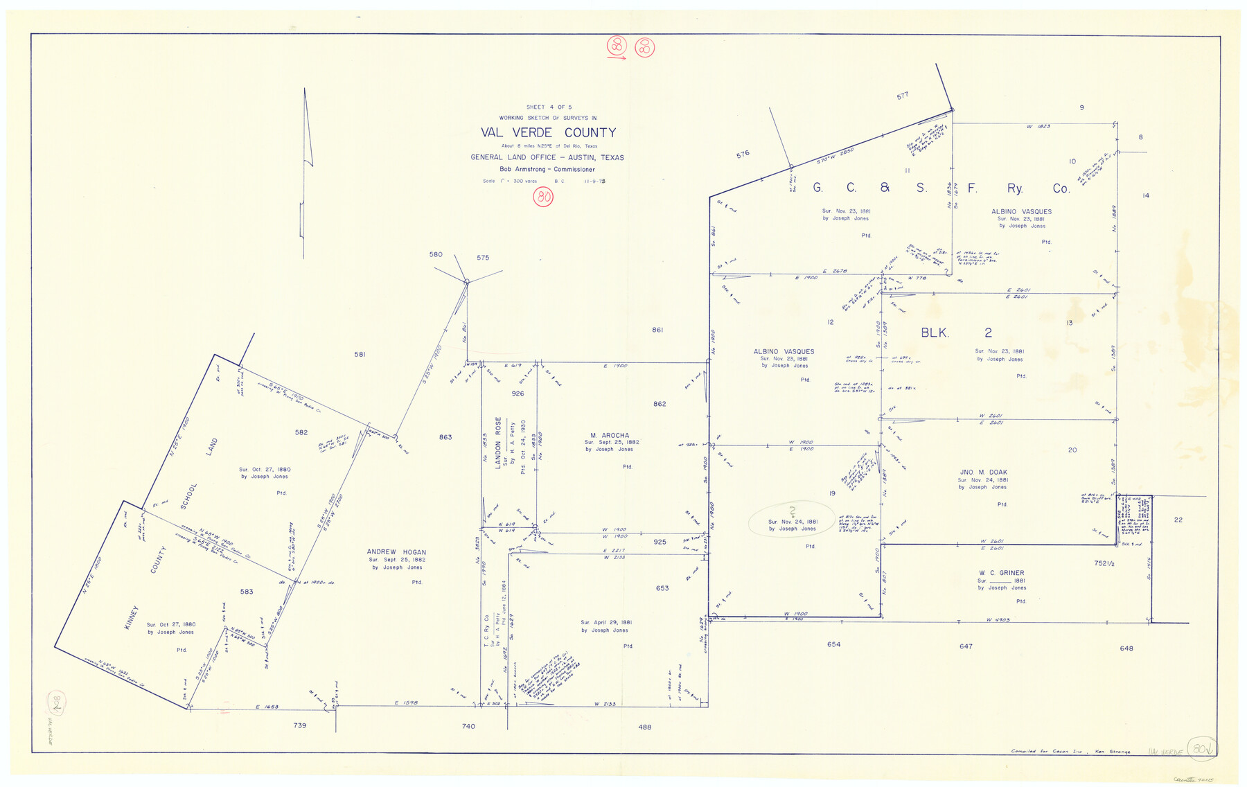
Val Verde County Working Sketch 80
-
Map/Doc
72215
-
Collection
General Map Collection
-
Object Dates
11/9/1973 (Creation Date)
-
People and Organizations
Beverly Christian (Draftsman)
-
Counties
Val Verde
-
Subjects
Surveying Working Sketch
-
Height x Width
29.1 x 46.1 inches
73.9 x 117.1 cm
-
Scale
1" = 300 varas
Part of: General Map Collection
Upton County Working Sketch 55

Print $20.00
- Digital $50.00
Upton County Working Sketch 55
Size 25.7 x 36.7 inches
Map/Doc 69552
Roberts County Working Sketch 24

Print $20.00
- Digital $50.00
Roberts County Working Sketch 24
1981
Size 25.8 x 36.9 inches
Map/Doc 63550
Flight Mission No. DCL-7C, Frame 60, Kenedy County

Print $20.00
- Digital $50.00
Flight Mission No. DCL-7C, Frame 60, Kenedy County
1943
Size 15.3 x 15.3 inches
Map/Doc 86048
Sterling County

Print $40.00
- Digital $50.00
Sterling County
1926
Size 48.5 x 34.7 inches
Map/Doc 63048
A Map of the Cotton Kingdom and its Dependencies in America

Print $20.00
- Digital $50.00
A Map of the Cotton Kingdom and its Dependencies in America
1861
Size 12.2 x 18.6 inches
Map/Doc 96573
Comanche County Sketch File 8

Print $4.00
- Digital $50.00
Comanche County Sketch File 8
1853
Size 13.1 x 8.2 inches
Map/Doc 19066
[Sketch for Mineral Application 26501 - Sabine River, T. A. Oldhausen]
![2839, [Sketch for Mineral Application 26501 - Sabine River, T. A. Oldhausen], General Map Collection](https://historictexasmaps.com/wmedia_w700/maps/2839.tif.jpg)
Print $20.00
- Digital $50.00
[Sketch for Mineral Application 26501 - Sabine River, T. A. Oldhausen]
1931
Size 17.7 x 36.4 inches
Map/Doc 2839
Howard County

Print $20.00
- Digital $50.00
Howard County
1922
Size 41.3 x 35.2 inches
Map/Doc 73185
Irion County Rolled Sketch 21

Print $40.00
- Digital $50.00
Irion County Rolled Sketch 21
Size 52.8 x 44.0 inches
Map/Doc 9256
Hays County Sketch File 5

Print $4.00
- Digital $50.00
Hays County Sketch File 5
1847
Size 12.7 x 8.3 inches
Map/Doc 26206
Martin County Rolled Sketch 3

Print $20.00
- Digital $50.00
Martin County Rolled Sketch 3
Size 29.2 x 15.4 inches
Map/Doc 6664
Galveston County Working Sketch 10

Print $40.00
- Digital $50.00
Galveston County Working Sketch 10
1967
Size 24.7 x 119.8 inches
Map/Doc 69347
You may also like
Fort Bend County Sketch File 14

Print $24.00
- Digital $50.00
Fort Bend County Sketch File 14
1890
Size 12.3 x 7.4 inches
Map/Doc 22913
San Patricio County Sketch File 39

Print $8.00
- Digital $50.00
San Patricio County Sketch File 39
Size 12.9 x 8.4 inches
Map/Doc 36232
Bandera County Working Sketch 46

Print $20.00
- Digital $50.00
Bandera County Working Sketch 46
1981
Size 28.0 x 37.4 inches
Map/Doc 67642
Block 11, Capitol Syndicate Subdivision of Capitol Land Reservation Leagues

Print $20.00
- Digital $50.00
Block 11, Capitol Syndicate Subdivision of Capitol Land Reservation Leagues
Size 25.0 x 26.2 inches
Map/Doc 90737
Brazoria County NRC Article 33.136 Sketch 6

Print $22.00
- Digital $50.00
Brazoria County NRC Article 33.136 Sketch 6
2004
Size 24.6 x 35.2 inches
Map/Doc 82904

Dallas County Working Sketch 8

Print $20.00
- Digital $50.00
Dallas County Working Sketch 8
1953
Size 20.6 x 26.4 inches
Map/Doc 68574
Kleberg County Rolled Sketch 8

Print $20.00
- Digital $50.00
Kleberg County Rolled Sketch 8
1947
Size 33.0 x 42.0 inches
Map/Doc 9360
Upton County Working Sketch 55
Print $20.00
- Digital $50.00
Upton County Working Sketch 55
Size 25.7 x 36.7 inches
Map/Doc 69552
Three Sitios of Land Granted to Vicente Micheli April 28th 1806

Print $2.00
- Digital $50.00
Three Sitios of Land Granted to Vicente Micheli April 28th 1806
1835
Size 11.8 x 8.1 inches
Map/Doc 170
Ellis County Sketch File 18

Print $40.00
- Digital $50.00
Ellis County Sketch File 18
Size 16.0 x 12.8 inches
Map/Doc 21862
Coke County Sketch File 14

Print $6.00
- Digital $50.00
Coke County Sketch File 14
1891
Size 10.8 x 13.1 inches
Map/Doc 18598