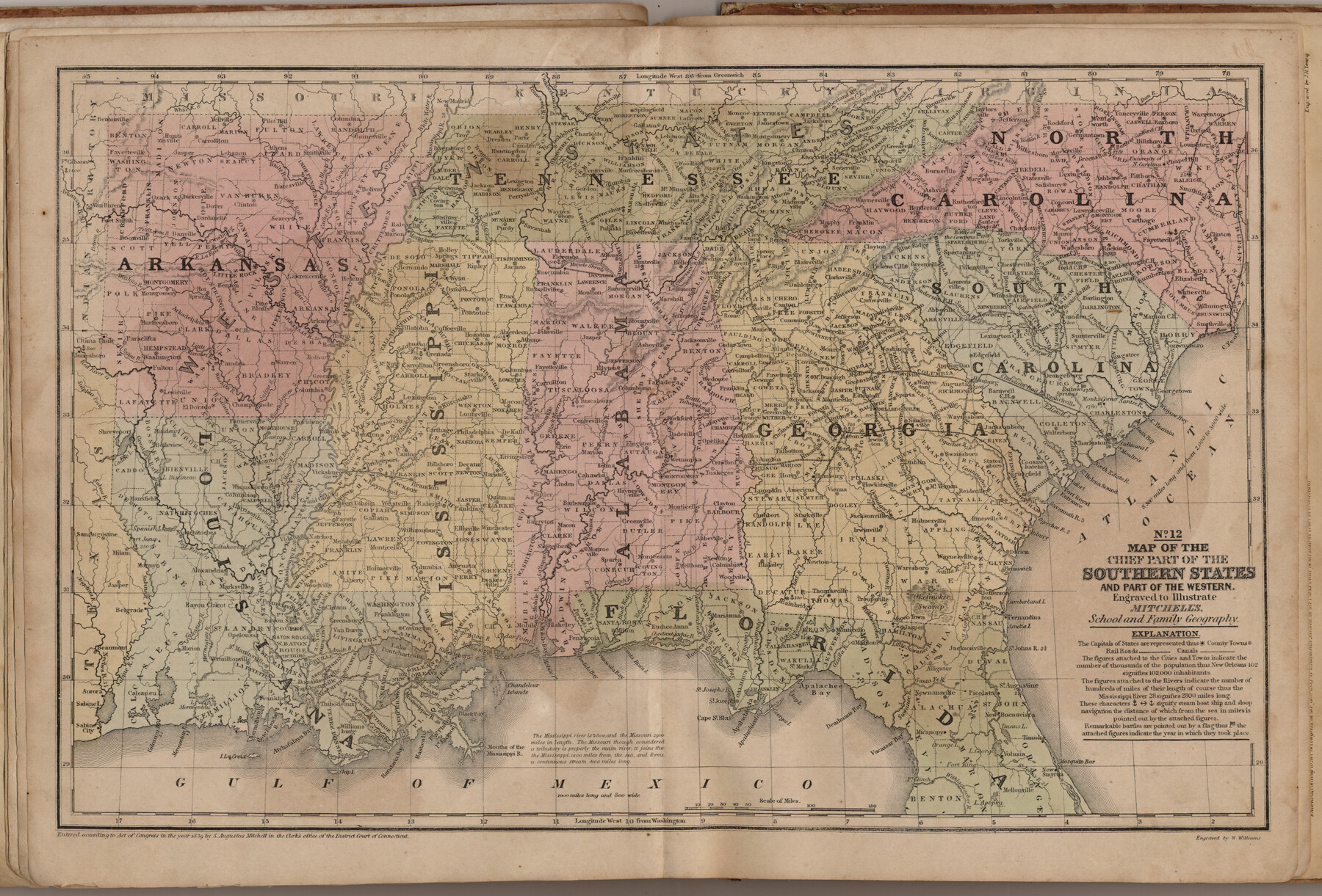
Map of the chief part of the Southern States and part of the Western engraved to illustrate Mitchell's school and family geography
Mitchell's school atlas map no. 12
-
Map/Doc
93497
-
Collection
General Map Collection
-
Object Dates
1839 (Creation Date)
2013/7/12 (File Date)
-
People and Organizations
Thomas, Cowperthwait and Co. (Publisher)
W. Williams (Printer)
Galen Greaser (Donor)
S. Augustus Mitchell (Author)
-
Subjects
Atlas
-
Height x Width
11.8 x 17.5 inches
30.0 x 44.5 cm
-
Comments
Donated by Galen Greaser in 2009. Map is part of volume: "Mitchell's school atlas: comprising the maps, etc., designed to illustrate Mitchell's school and family geography". See 93491 for complete atlas.
Related maps
Mitchell's school atlas: comprising the maps, etc., designed to illustrate Mitchell's school and family geography

Print $370.00
- Digital $50.00
Mitchell's school atlas: comprising the maps, etc., designed to illustrate Mitchell's school and family geography
1851
Size 12.0 x 9.6 inches
Map/Doc 93491
Part of: General Map Collection
Burleson County Sketch File 6

Print $4.00
- Digital $50.00
Burleson County Sketch File 6
1865
Size 8.0 x 9.3 inches
Map/Doc 16651
Dimmit County

Print $40.00
- Digital $50.00
Dimmit County
1916
Size 40.6 x 48.0 inches
Map/Doc 78341
Reeves County Sketch File 12

Print $20.00
- Digital $50.00
Reeves County Sketch File 12
Size 42.7 x 31.3 inches
Map/Doc 10588
Briscoe County Sketch File 5

Print $40.00
- Digital $50.00
Briscoe County Sketch File 5
Size 29.8 x 26.5 inches
Map/Doc 10994
Flight Mission No. BRA-8M, Frame 80, Jefferson County

Print $20.00
- Digital $50.00
Flight Mission No. BRA-8M, Frame 80, Jefferson County
1953
Size 15.9 x 15.6 inches
Map/Doc 85600
Starr County Rolled Sketch X

Print $121.00
- Digital $50.00
Starr County Rolled Sketch X
Size 13.3 x 8.1 inches
Map/Doc 75961
Coleman County

Print $40.00
- Digital $50.00
Coleman County
1897
Size 49.4 x 34.9 inches
Map/Doc 66758
Fort Bend County Working Sketch 28

Print $20.00
- Digital $50.00
Fort Bend County Working Sketch 28
1982
Size 15.8 x 20.1 inches
Map/Doc 69234
Hutchinson County Working Sketch 31

Print $20.00
- Digital $50.00
Hutchinson County Working Sketch 31
1978
Size 27.0 x 22.2 inches
Map/Doc 66391
Map of Polk County

Print $20.00
- Digital $50.00
Map of Polk County
1879
Size 27.1 x 20.8 inches
Map/Doc 3959
[Surveys in Austin's Colony along the San Bernardo River from the mouth of Peach Creek]
![209, [Surveys in Austin's Colony along the San Bernardo River from the mouth of Peach Creek], General Map Collection](https://historictexasmaps.com/wmedia_w700/maps/209.tif.jpg)
Print $20.00
- Digital $50.00
[Surveys in Austin's Colony along the San Bernardo River from the mouth of Peach Creek]
1821
Size 23.4 x 10.6 inches
Map/Doc 209
Tom Green County Sketch File 81

Print $20.00
- Digital $50.00
Tom Green County Sketch File 81
Size 16.6 x 23.4 inches
Map/Doc 12453
You may also like
Potter County Boundary File 3a

Print $4.00
- Digital $50.00
Potter County Boundary File 3a
Size 11.2 x 8.7 inches
Map/Doc 57977
Montgomery County Rolled Sketch 42

Print $20.00
- Digital $50.00
Montgomery County Rolled Sketch 42
1939
Size 13.9 x 20.2 inches
Map/Doc 6816
Val Verde County Sketch File XXX9

Print $4.00
- Digital $50.00
Val Verde County Sketch File XXX9
Size 11.0 x 8.5 inches
Map/Doc 39108
![89627, [Blks. 46 & 47], Twichell Survey Records](https://historictexasmaps.com/wmedia_w700/maps/89627-1.tif.jpg)
Marion County Working Sketch 7

Print $20.00
- Digital $50.00
Marion County Working Sketch 7
1918
Size 27.9 x 27.7 inches
Map/Doc 70782
[SE/4 of NW/4 of King Co.]
![89925, [SE/4 of NW/4 of King Co.], Twichell Survey Records](https://historictexasmaps.com/wmedia_w700/maps/89925-1.tif.jpg)
Print $40.00
- Digital $50.00
[SE/4 of NW/4 of King Co.]
Size 43.7 x 55.5 inches
Map/Doc 89925
Limestone County Boundary File 59

Print $34.00
- Digital $50.00
Limestone County Boundary File 59
Size 7.4 x 8.7 inches
Map/Doc 56299
Flight Mission No. BRE-1P, Frame 118, Nueces County

Print $20.00
- Digital $50.00
Flight Mission No. BRE-1P, Frame 118, Nueces County
1956
Size 17.8 x 21.2 inches
Map/Doc 86684
Starr County Boundary File 1

Print $24.00
- Digital $50.00
Starr County Boundary File 1
Size 13.0 x 8.5 inches
Map/Doc 58801
San Patricio County Rolled Sketch 40

Print $20.00
- Digital $50.00
San Patricio County Rolled Sketch 40
1917
Size 26.0 x 36.0 inches
Map/Doc 7726
Young Territory

Print $20.00
- Digital $50.00
Young Territory
1865
Size 29.7 x 30.5 inches
Map/Doc 1978
McLennan County Working Sketch 3

Print $20.00
- Digital $50.00
McLennan County Working Sketch 3
1941
Size 18.0 x 17.9 inches
Map/Doc 70696