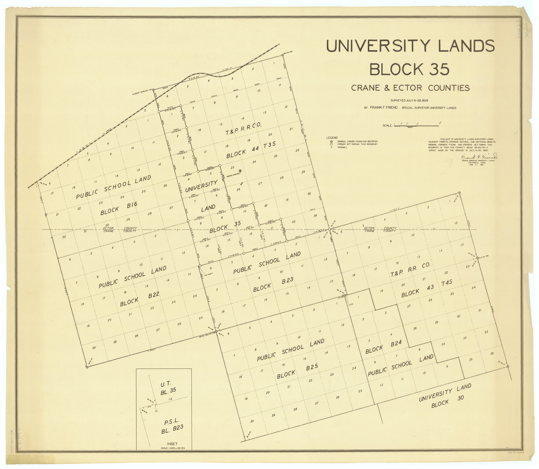
University Lands, Block 35, Crane & Ector Counties
-
Map/Doc
2406
-
Collection
General Map Collection
-
Object Dates
1935 (Creation Date)
-
People and Organizations
Frank F. Friend (Surveyor/Engineer)
-
Counties
Crane Ector
-
Height x Width
39.9 x 45.5 inches
101.3 x 115.6 cm
-
Medium
photocopy
-
Scale
1000 varas
Part of: General Map Collection
Calhoun County Rolled Sketch 12

Print $40.00
- Digital $50.00
Calhoun County Rolled Sketch 12
1940
Size 30.2 x 54.8 inches
Map/Doc 43619

Sutton County Sketch File 6

Print $8.00
- Digital $50.00
Sutton County Sketch File 6
1897
Size 14.0 x 9.0 inches
Map/Doc 37358

Mason County Sketch File 13

Print $4.00
- Digital $50.00
Mason County Sketch File 13
Size 7.3 x 6.2 inches
Map/Doc 30701
Brewster County Working Sketch 78

Print $20.00
- Digital $50.00
Brewster County Working Sketch 78
1970
Size 31.6 x 44.3 inches
Map/Doc 67678
Bowie County Boundary File 72 (23)

Print $10.00
- Digital $50.00
Bowie County Boundary File 72 (23)
Size 13.0 x 8.0 inches
Map/Doc 50694
Jasper County Rolled Sketch 7B

Print $20.00
- Digital $50.00
Jasper County Rolled Sketch 7B
Size 19.7 x 11.6 inches
Map/Doc 6355
Travis County Working Sketch 12

Print $20.00
- Digital $50.00
Travis County Working Sketch 12
1920
Size 47.8 x 26.1 inches
Map/Doc 69396
Colorado County Working Sketch 22

Print $20.00
- Digital $50.00
Colorado County Working Sketch 22
1964
Size 31.9 x 42.5 inches
Map/Doc 68122
[Surveys in the Bexar District along the Sabinal and Frio Rivers]
![3167, [Surveys in the Bexar District along the Sabinal and Frio Rivers], General Map Collection](https://historictexasmaps.com/wmedia_w700/maps/3167.tif.jpg)
Print $20.00
- Digital $50.00
[Surveys in the Bexar District along the Sabinal and Frio Rivers]
1846
Size 16.8 x 19.6 inches
Map/Doc 3167
McMullen County Rolled Sketch 20

Print $20.00
- Digital $50.00
McMullen County Rolled Sketch 20
Size 27.7 x 21.7 inches
Map/Doc 6736
You may also like
[Capitol Leagues 217-228, 238, and vicinity]
![90695, [Capitol Leagues 217-228, 238, and vicinity], Twichell Survey Records](https://historictexasmaps.com/wmedia_w700/maps/90695-1.tif.jpg)
Print $20.00
- Digital $50.00
[Capitol Leagues 217-228, 238, and vicinity]
Size 23.8 x 12.9 inches
Map/Doc 90695
[Leagues 27, 28, 69, 70, 71, 72, and 73]
![91097, [Leagues 27, 28, 69, 70, 71, 72, and 73], Twichell Survey Records](https://historictexasmaps.com/wmedia_w700/maps/91097-1.tif.jpg)
Print $20.00
- Digital $50.00
[Leagues 27, 28, 69, 70, 71, 72, and 73]
Size 23.8 x 16.3 inches
Map/Doc 91097
Flight Mission No. BRA-16M, Frame 161, Jefferson County

Print $20.00
- Digital $50.00
Flight Mission No. BRA-16M, Frame 161, Jefferson County
1953
Size 18.5 x 22.3 inches
Map/Doc 85759
Kerr County Working Sketch 26

Print $20.00
- Digital $50.00
Kerr County Working Sketch 26
1969
Size 31.2 x 32.1 inches
Map/Doc 70057

Parker County Working Sketch 27

Print $20.00
- Digital $50.00
Parker County Working Sketch 27
2009
Map/Doc 89001
Upton County Rolled Sketch 59A

Print $20.00
- Digital $50.00
Upton County Rolled Sketch 59A
Size 35.4 x 45.6 inches
Map/Doc 76422
Flight Mission No. CRC-3R, Frame 50, Chambers County

Print $20.00
- Digital $50.00
Flight Mission No. CRC-3R, Frame 50, Chambers County
1956
Size 18.7 x 22.3 inches
Map/Doc 84823
Rusk County Working Sketch 26

Print $20.00
- Digital $50.00
Rusk County Working Sketch 26
1938
Size 42.8 x 36.8 inches
Map/Doc 63662
San Patricio County Aerial Photograph Index Sheet 5

Print $20.00
- Digital $50.00
San Patricio County Aerial Photograph Index Sheet 5
1957
Size 23.9 x 19.2 inches
Map/Doc 83747
[River Sections 54-73, part of Blk. GG]
![90317, [River Sections 54-73, part of Blk. GG], Twichell Survey Records](https://historictexasmaps.com/wmedia_w700/maps/90317-1.tif.jpg)
Print $20.00
- Digital $50.00
[River Sections 54-73, part of Blk. GG]
Size 37.0 x 35.9 inches
Map/Doc 90317