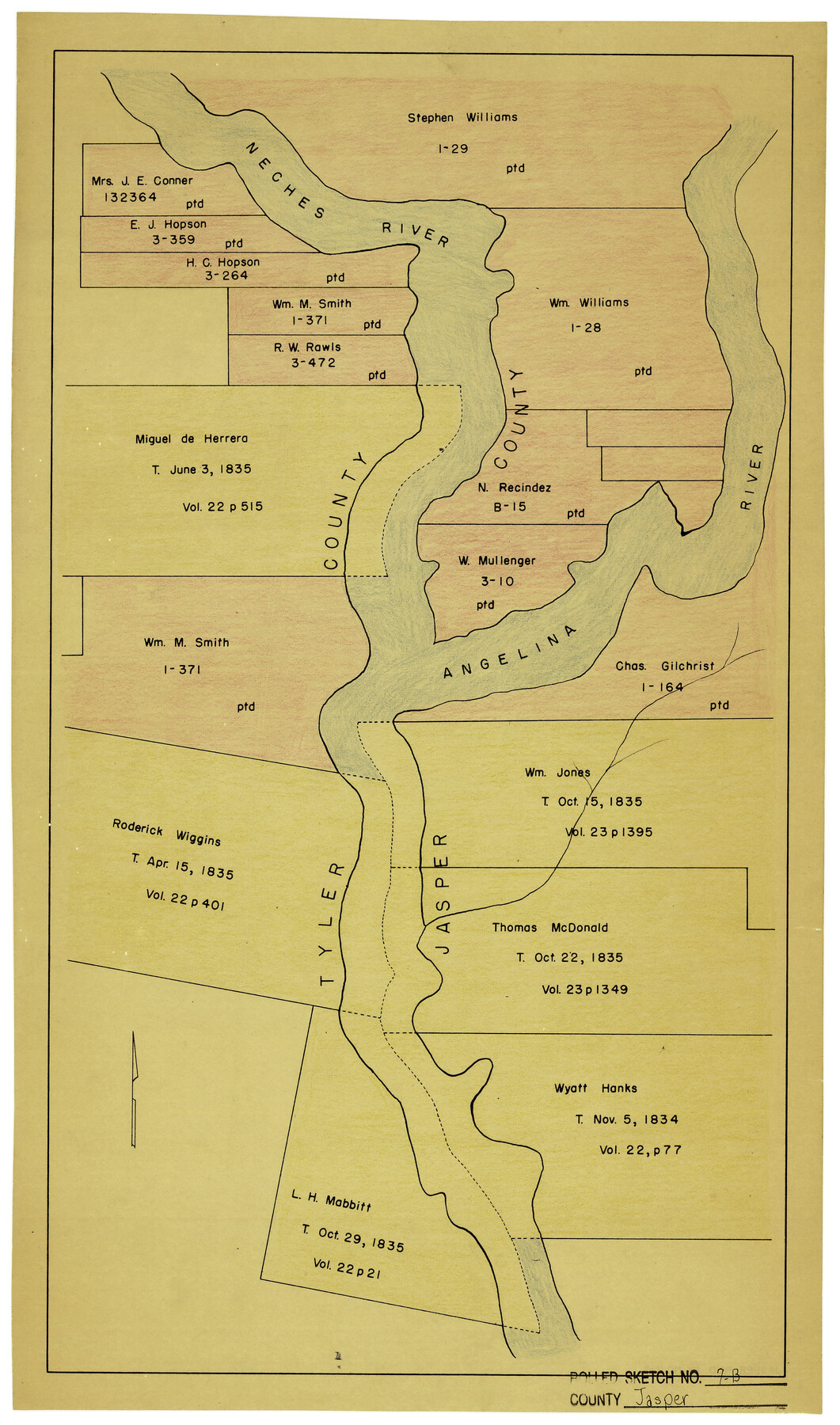
Jasper County Rolled Sketch 7B
[Office sketch showing surveys along the Neches & Angelina Rivers]
-
Map/Doc
6355
-
Collection
General Map Collection
-
Counties
Jasper Tyler
-
Subjects
Surveying Rolled Sketch
-
Height x Width
19.7 x 11.6 inches
50.0 x 29.5 cm
-
Medium
blueprint/diazo
Part of: General Map Collection
Harris County Working Sketch 22

Print $20.00
- Digital $50.00
Harris County Working Sketch 22
Size 17.5 x 22.0 inches
Map/Doc 65914
Flight Mission No. BQY-14M, Frame 181, Harris County

Print $20.00
- Digital $50.00
Flight Mission No. BQY-14M, Frame 181, Harris County
1953
Size 18.7 x 22.2 inches
Map/Doc 85297
Hardin County Rolled Sketch W

Print $40.00
- Digital $50.00
Hardin County Rolled Sketch W
1937
Size 48.6 x 44.4 inches
Map/Doc 9105
Stonewall County Boundary File 3a

Print $68.00
- Digital $50.00
Stonewall County Boundary File 3a
Size 14.4 x 9.0 inches
Map/Doc 58970
Trinity River, Onion Creek Station Sheet/Chambers Creek

Print $6.00
- Digital $50.00
Trinity River, Onion Creek Station Sheet/Chambers Creek
1931
Size 35.1 x 32.4 inches
Map/Doc 65234
Anderson County Boundary File 1

Print $10.00
- Digital $50.00
Anderson County Boundary File 1
Size 14.2 x 8.6 inches
Map/Doc 49726
Crockett County Rolled Sketch 58

Print $20.00
- Digital $50.00
Crockett County Rolled Sketch 58
Size 19.0 x 32.8 inches
Map/Doc 5600

Real County Working Sketch 85

Print $20.00
- Digital $50.00
Real County Working Sketch 85
1988
Size 27.0 x 30.0 inches
Map/Doc 71977
Navigation Maps of Gulf Intracoastal Waterway, Port Arthur to Brownsville, Texas

Print $4.00
- Digital $50.00
Navigation Maps of Gulf Intracoastal Waterway, Port Arthur to Brownsville, Texas
1951
Size 16.6 x 21.3 inches
Map/Doc 65438
McLennan County Sketch File 1a

Print $4.00
- Digital $50.00
McLennan County Sketch File 1a
1872
Size 8.0 x 12.2 inches
Map/Doc 31226
Current Miscellaneous File 113

Print $52.00
- Digital $50.00
Current Miscellaneous File 113
Size 23.8 x 17.1 inches
Map/Doc 74787
You may also like
Flight Mission No. DQN-5K, Frame 52, Calhoun County

Print $20.00
- Digital $50.00
Flight Mission No. DQN-5K, Frame 52, Calhoun County
1953
Size 18.6 x 22.3 inches
Map/Doc 84397
Gillespie County

Print $20.00
- Digital $50.00
Gillespie County
1877
Size 20.1 x 24.5 inches
Map/Doc 3583
Map of Texas from the most recent authorities

Print $20.00
Map of Texas from the most recent authorities
1845
Size 13.5 x 17.1 inches
Map/Doc 94574
Blanco County Sketch File 30

Print $5.00
- Digital $50.00
Blanco County Sketch File 30
Size 9.1 x 10.6 inches
Map/Doc 14627
Uvalde County Working Sketch 9

Print $20.00
- Digital $50.00
Uvalde County Working Sketch 9
1942
Size 18.3 x 24.4 inches
Map/Doc 72079
Morris County Rolled Sketch 2A

Print $20.00
- Digital $50.00
Morris County Rolled Sketch 2A
Size 24.0 x 18.7 inches
Map/Doc 10272
Borden County Working Sketch 8

Print $20.00
- Digital $50.00
Borden County Working Sketch 8
1951
Size 24.7 x 34.4 inches
Map/Doc 67468
Erath County Sketch File 10

Print $4.00
- Digital $50.00
Erath County Sketch File 10
1871
Size 8.1 x 10.3 inches
Map/Doc 22275
La Salle County Working Sketch 45

Print $20.00
- Digital $50.00
La Salle County Working Sketch 45
1980
Size 35.5 x 30.7 inches
Map/Doc 70346
Presidio County Working Sketch 37

Print $20.00
- Digital $50.00
Presidio County Working Sketch 37
1948
Size 26.9 x 43.3 inches
Map/Doc 71714
Newton County Working Sketch 8

Print $20.00
- Digital $50.00
Newton County Working Sketch 8
1937
Size 23.2 x 18.5 inches
Map/Doc 71254
Atascosa County Sketch File 3c

Print $4.00
- Digital $50.00
Atascosa County Sketch File 3c
1858
Size 14.3 x 7.3 inches
Map/Doc 13743