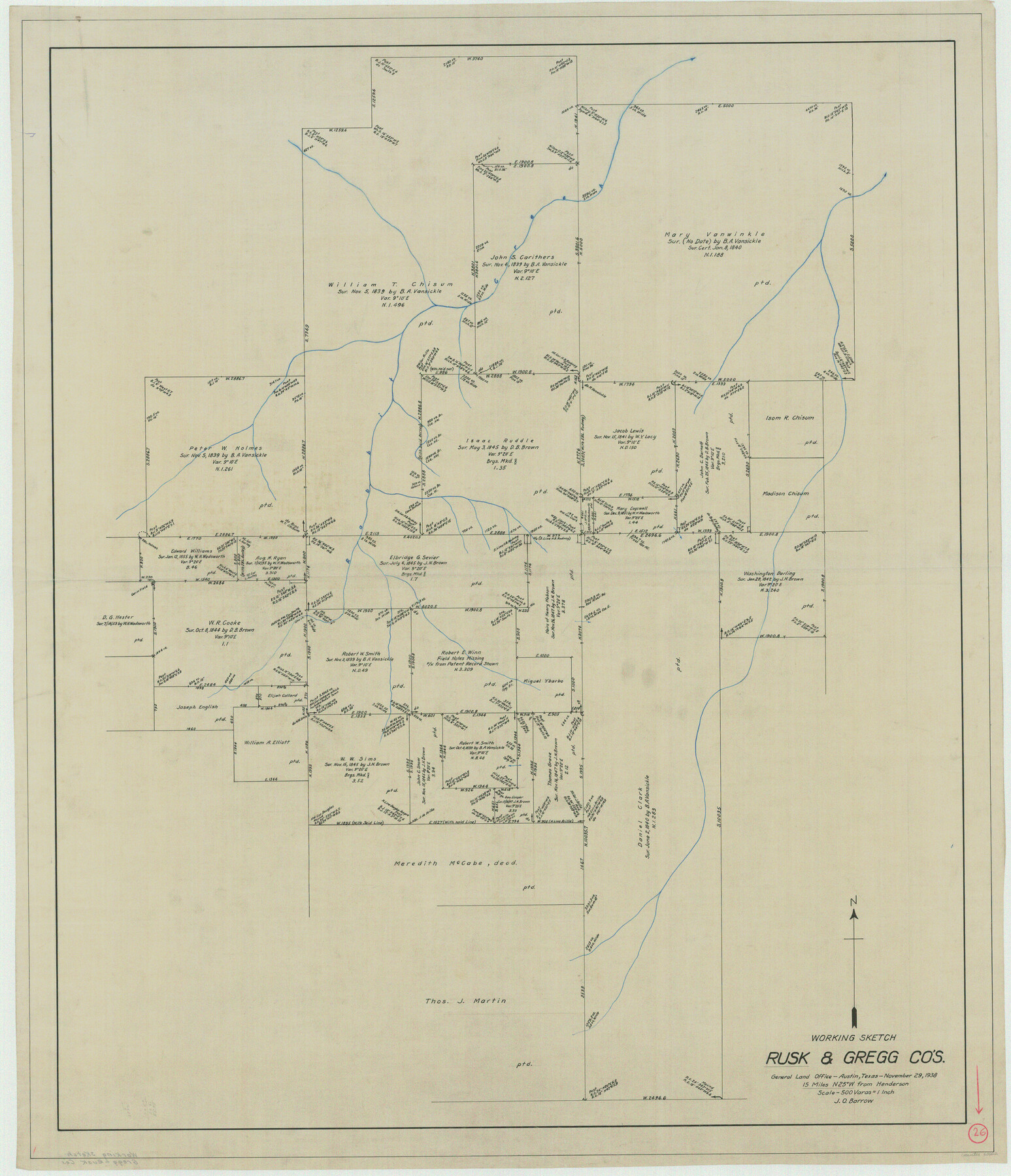
Rusk County Working Sketch 26
-
Map/Doc
63662
-
Collection
General Map Collection
-
Object Dates
11/29/1938 (Creation Date)
-
People and Organizations
J.O. Barrow (Draftsman)
-
Counties
Rusk Gregg
-
Subjects
Surveying Working Sketch
-
Height x Width
42.8 x 36.8 inches
108.7 x 93.5 cm
-
Scale
1" = 500 varas
Part of: General Map Collection
Burnet County Sketch File 46

Print $4.00
- Digital $50.00
Burnet County Sketch File 46
1873
Size 12.8 x 8.5 inches
Map/Doc 16773
Gulf Intracoastal Waterway, Tex. - Aransas Bay to Corpus Christi Bay - Modified Route of Main Channel/Dredging

Print $20.00
- Digital $50.00
Gulf Intracoastal Waterway, Tex. - Aransas Bay to Corpus Christi Bay - Modified Route of Main Channel/Dredging
1958
Size 31.5 x 43.0 inches
Map/Doc 61898
Zavala County

Print $20.00
- Digital $50.00
Zavala County
1977
Size 36.6 x 41.6 inches
Map/Doc 77468

Map of Victoria County

Print $20.00
- Digital $50.00
Map of Victoria County
1873
Size 20.9 x 19.3 inches
Map/Doc 4639
Corpus Christi Harbor

Print $40.00
- Digital $50.00
Corpus Christi Harbor
1976
Size 37.1 x 51.5 inches
Map/Doc 73480
Roberts County Sketch File 7

Print $16.00
- Digital $50.00
Roberts County Sketch File 7
1992
Size 14.3 x 8.8 inches
Map/Doc 35316
Edwards County Working Sketch 58

Print $20.00
- Digital $50.00
Edwards County Working Sketch 58
1953
Size 22.4 x 29.8 inches
Map/Doc 68934

Stephens County Sketch File 2

Print $4.00
- Digital $50.00
Stephens County Sketch File 2
1870
Size 12.9 x 8.2 inches
Map/Doc 37013
Harrison County Sketch File 4

Print $4.00
- Digital $50.00
Harrison County Sketch File 4
Size 9.0 x 8.0 inches
Map/Doc 26040
Comal County Rolled Sketch 1

Print $20.00
- Digital $50.00
Comal County Rolled Sketch 1
1972
Size 24.2 x 19.6 inches
Map/Doc 5535
You may also like
Grayson County Working Sketch 18

Print $20.00
- Digital $50.00
Grayson County Working Sketch 18
1955
Size 22.8 x 21.1 inches
Map/Doc 63257
Trinity County Boundary File 88a

Print $4.00
- Digital $50.00
Trinity County Boundary File 88a
Size 12.6 x 7.8 inches
Map/Doc 59478
Medina County Rolled Sketch 17

Print $20.00
- Digital $50.00
Medina County Rolled Sketch 17
1979
Size 32.3 x 18.9 inches
Map/Doc 6750
University Land Block 46, Culberson County, Texas

Print $20.00
- Digital $50.00
University Land Block 46, Culberson County, Texas
1938
Size 35.1 x 22.0 inches
Map/Doc 2410
Runnels County Rolled Sketch 36

Print $40.00
- Digital $50.00
Runnels County Rolled Sketch 36
Size 61.2 x 43.0 inches
Map/Doc 76027
Travis County Rolled Sketch 25

Print $20.00
- Digital $50.00
Travis County Rolled Sketch 25
1942
Size 22.1 x 29.2 inches
Map/Doc 8026
Duval County Working Sketch 6

Print $20.00
- Digital $50.00
Duval County Working Sketch 6
1935
Size 26.9 x 21.8 inches
Map/Doc 68719
Hays County Sketch File 32

Print $8.00
- Digital $50.00
Hays County Sketch File 32
Size 14.3 x 8.8 inches
Map/Doc 26264
Fannin County Sketch File 6

Print $20.00
- Digital $50.00
Fannin County Sketch File 6
1857
Size 17.0 x 14.5 inches
Map/Doc 11469
Brazos County Working Sketch Graphic Index

Print $20.00
- Digital $50.00
Brazos County Working Sketch Graphic Index
1922
Size 46.7 x 30.9 inches
Map/Doc 76472
Brewster County Rolled Sketch 52

Print $40.00
- Digital $50.00
Brewster County Rolled Sketch 52
1935
Size 24.5 x 59.4 inches
Map/Doc 8479
Map of Young County

Print $20.00
- Digital $50.00
Map of Young County
1880
Size 22.0 x 20.3 inches
Map/Doc 4174