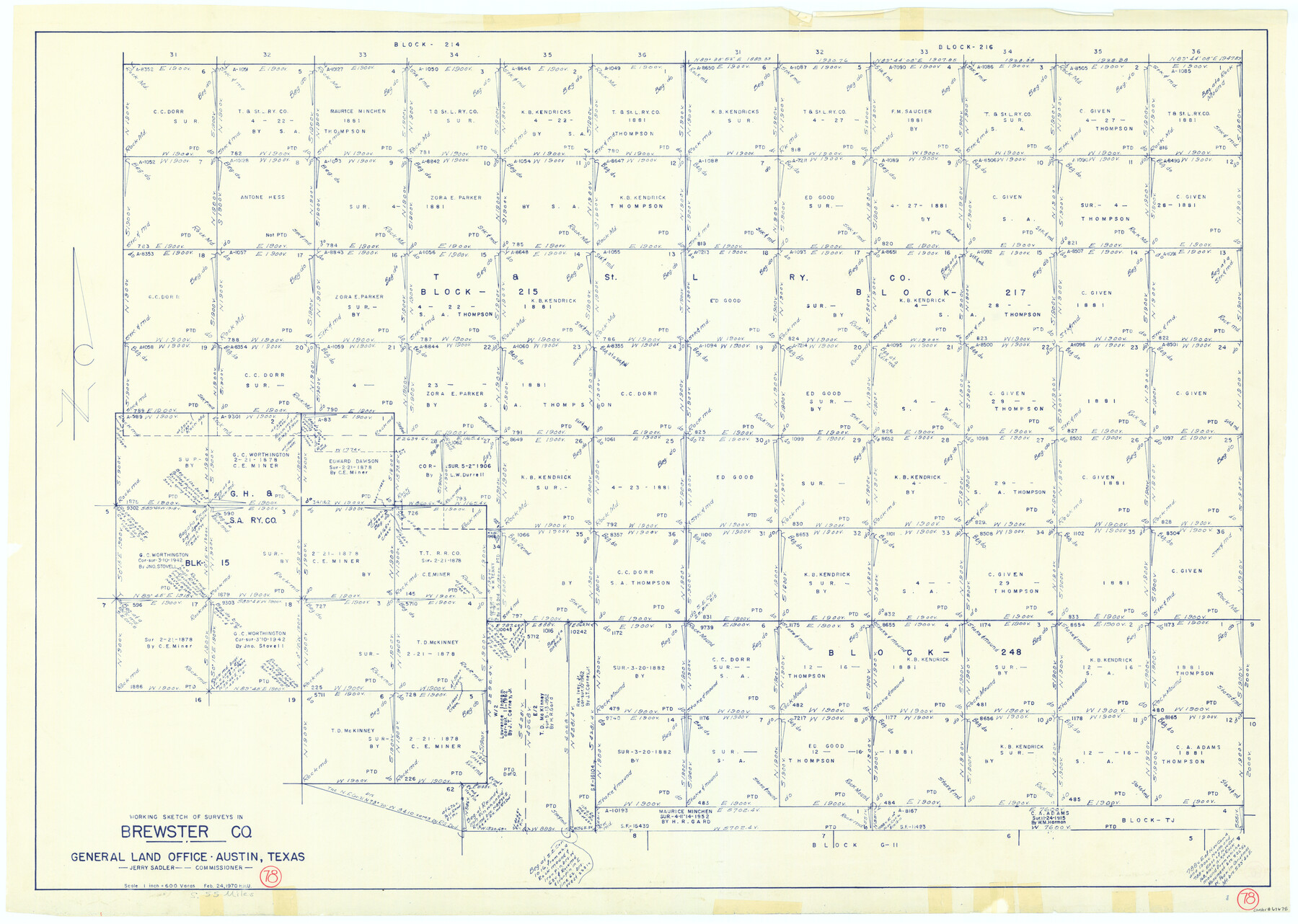
Brewster County Working Sketch 78
-
Map/Doc
67678
-
Collection
General Map Collection
-
Object Dates
2/24/1970 (Creation Date)
-
People and Organizations
Herbert H. Ulbricht (Draftsman)
-
Counties
Brewster
-
Subjects
Surveying Working Sketch
-
Height x Width
31.6 x 44.3 inches
80.3 x 112.5 cm
-
Scale
1" = 600 varas
Part of: General Map Collection
Cameron County Rolled Sketch US

Print $20.00
- Digital $50.00
Cameron County Rolled Sketch US
1913
Size 31.1 x 26.3 inches
Map/Doc 5398
Dickens County Sketch File M

Print $59.00
- Digital $50.00
Dickens County Sketch File M
1908
Size 14.6 x 9.1 inches
Map/Doc 20911
Travis County Working Sketch 42

Print $20.00
- Digital $50.00
Travis County Working Sketch 42
1974
Size 32.5 x 35.2 inches
Map/Doc 69426
Right of Way and Track Map, the Missouri, Kansas and Texas Ry. of Texas operated by the Missouri, Kansas and Texas Ry. of Texas, San Antonio Division

Print $40.00
- Digital $50.00
Right of Way and Track Map, the Missouri, Kansas and Texas Ry. of Texas operated by the Missouri, Kansas and Texas Ry. of Texas, San Antonio Division
1918
Size 25.1 x 57.7 inches
Map/Doc 64585
Orange County Working Sketch 37

Print $40.00
- Digital $50.00
Orange County Working Sketch 37
1962
Size 37.7 x 54.0 inches
Map/Doc 71369
Hartley County Sketch File 9

Print $12.00
- Digital $50.00
Hartley County Sketch File 9
1903
Size 10.8 x 7.2 inches
Map/Doc 26094
Harris County Sketch File 54

Print $6.00
- Digital $50.00
Harris County Sketch File 54
Size 14.5 x 8.8 inches
Map/Doc 25451
Jefferson County Working Sketch 7

Print $20.00
- Digital $50.00
Jefferson County Working Sketch 7
1931
Size 18.0 x 18.6 inches
Map/Doc 66550
Jasper County Rolled Sketch 6

Print $20.00
- Digital $50.00
Jasper County Rolled Sketch 6
1948
Size 27.8 x 43.7 inches
Map/Doc 6353
Map of Sabine County

Print $20.00
- Digital $50.00
Map of Sabine County
1896
Size 25.8 x 17.9 inches
Map/Doc 63012
Zavala County Rolled Sketch 27

Print $20.00
- Digital $50.00
Zavala County Rolled Sketch 27
1955
Size 21.2 x 20.0 inches
Map/Doc 8329
[Sketch for Mineral Application 12206 - Cow Bayou, O. B. Sawyer]
![65569, [Sketch for Mineral Application 12206 - Cow Bayou, O. B. Sawyer], General Map Collection](https://historictexasmaps.com/wmedia_w700/maps/65569.tif.jpg)
Print $40.00
- Digital $50.00
[Sketch for Mineral Application 12206 - Cow Bayou, O. B. Sawyer]
Size 63.3 x 36.5 inches
Map/Doc 65569
You may also like
[Map showing Jno. H. Gibson Block D]
![92005, [Map showing Jno. H. Gibson Block D], Twichell Survey Records](https://historictexasmaps.com/wmedia_w700/maps/92005-1.tif.jpg)
Print $20.00
- Digital $50.00
[Map showing Jno. H. Gibson Block D]
Size 18.3 x 15.9 inches
Map/Doc 92005
The Republic County of Robertson. Spring 1842

Print $20.00
The Republic County of Robertson. Spring 1842
2020
Size 16.9 x 21.7 inches
Map/Doc 96263
Jim Hogg County Boundary File 1

Print $16.00
- Digital $50.00
Jim Hogg County Boundary File 1
Size 11.4 x 8.8 inches
Map/Doc 55519
Flight Mission No. BQR-5K, Frame 62, Brazoria County

Print $20.00
- Digital $50.00
Flight Mission No. BQR-5K, Frame 62, Brazoria County
1952
Size 18.9 x 22.6 inches
Map/Doc 84007
Uvalde County Working Sketch 20

Print $20.00
- Digital $50.00
Uvalde County Working Sketch 20
1950
Size 41.5 x 32.4 inches
Map/Doc 72090
Pecos County Sketch File 37

Print $4.00
- Digital $50.00
Pecos County Sketch File 37
1911
Size 8.9 x 8.3 inches
Map/Doc 33718
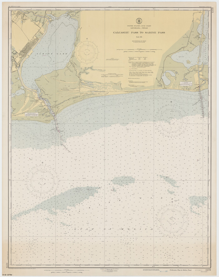
Calcasieu Pass to Sabine Pass
Print $20.00
- Digital $50.00
Calcasieu Pass to Sabine Pass
1950
Size 44.8 x 35.4 inches
Map/Doc 69808
Sutton County Sketch File 57

Print $24.00
- Digital $50.00
Sutton County Sketch File 57
1961
Size 11.2 x 8.8 inches
Map/Doc 37542
[H. & G. N. Block 1]
![90944, [H. & G. N. Block 1], Twichell Survey Records](https://historictexasmaps.com/wmedia_w700/maps/90944-1.tif.jpg)
Print $20.00
- Digital $50.00
[H. & G. N. Block 1]
1873
Size 17.7 x 14.3 inches
Map/Doc 90944
Travis County Working Sketch 15

Print $20.00
- Digital $50.00
Travis County Working Sketch 15
1939
Size 16.1 x 19.7 inches
Map/Doc 69399
Hemphill County Working Sketch 28

Print $40.00
- Digital $50.00
Hemphill County Working Sketch 28
1974
Size 61.8 x 43.5 inches
Map/Doc 66123
Van Zandt County Sketch File 13

Print $4.00
- Digital $50.00
Van Zandt County Sketch File 13
1858
Size 10.6 x 8.2 inches
Map/Doc 39402