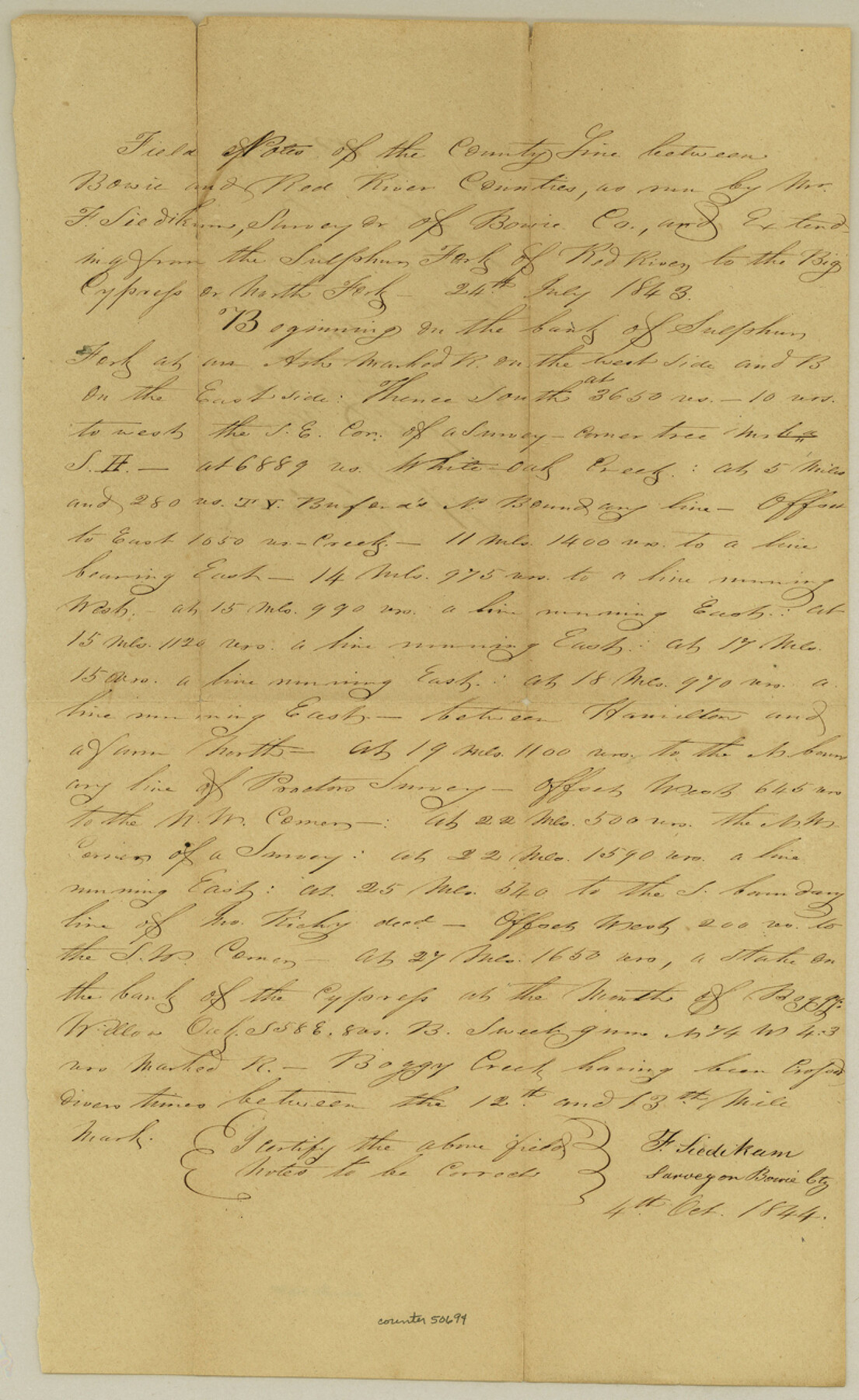
Bowie County Boundary File 72 (23)
Boundary between the Counties of Red River and Bowie
- 
                          Map/Doc
50694
 - 
                            Collection
General Map Collection
 - 
                            Counties
Bowie
 - 
                            Subjects
County Boundaries
 - 
                            Height x Width
13.0 x 8.0 inches
33.0 x 20.3 cm
 
Part of: General Map Collection
            Flight Mission No. BRE-2P, Frame 14, Nueces County


                                            Print $20.00                    
                                             -                         Digital $50.00                                    
                Flight Mission No. BRE-2P, Frame 14, Nueces County
1956
Size 18.5 x 22.6 inches
                                Map/Doc 86723
            
            DeWitt County Working Sketch 6


                                            Print $20.00                    
                                             -                         Digital $50.00                                    
                DeWitt County Working Sketch 6
1977
Size 30.6 x 26.6 inches
                                Map/Doc 68596
            
            Cameron County


                                            Print $20.00                    
                                             -                         Digital $50.00                                    
                Cameron County
1913
Size 29.8 x 33.9 inches
                                Map/Doc 66746
            
            Wilbarger County Working Sketch 14


                                            Print $20.00                    
                                             -                         Digital $50.00                                    
                Wilbarger County Working Sketch 14
1955
Size 24.8 x 21.7 inches
                                Map/Doc 72552
            
            Dimmit County Working Sketch 10


                                            Print $20.00                    
                                             -                         Digital $50.00                                    
                Dimmit County Working Sketch 10
1934
Size 24.2 x 40.3 inches
                                Map/Doc 68671
            
            Brewster County Rolled Sketch 114


                                            Print $20.00                    
                                             -                         Digital $50.00                                    
                Brewster County Rolled Sketch 114
1964
Size 11.4 x 18.4 inches
                                Map/Doc 5277
            
            Sutton County Working Sketch 37


                                            Print $20.00                    
                                             -                         Digital $50.00                                    
                Sutton County Working Sketch 37
1947
Size 31.0 x 41.4 inches
                                Map/Doc 62380
            
            Plat of a survey of the North part of section 16, Block 362, Martha McBride, Presidio County, Texas


                                            Print $6.00                    
                                             -                         Digital $50.00                                    
                Plat of a survey of the North part of section 16, Block 362, Martha McBride, Presidio County, Texas
1989
Size 25.5 x 35.0 inches
                                Map/Doc 60521
            
            Flight Mission No. BRA-16M, Frame 48, Jefferson County


                                            Print $20.00                    
                                             -                         Digital $50.00                                    
                Flight Mission No. BRA-16M, Frame 48, Jefferson County
1953
Size 18.6 x 22.5 inches
                                Map/Doc 85665
            
            Boundary Between the United States & Mexico Agreed upon by the Joint Commission under the Treaty of Guadalupe Hidalgo


                                            Print $20.00                    
                                             -                         Digital $50.00                                    
                Boundary Between the United States & Mexico Agreed upon by the Joint Commission under the Treaty of Guadalupe Hidalgo
1853
Size 18.2 x 26.4 inches
                                Map/Doc 72883
            
            Flight Mission No. CRC-3R, Frame 21, Chambers County


                                            Print $20.00                    
                                             -                         Digital $50.00                                    
                Flight Mission No. CRC-3R, Frame 21, Chambers County
1956
Size 18.6 x 22.2 inches
                                Map/Doc 84795
            
            Hutchinson County Rolled Sketch 39


                                            Print $20.00                    
                                             -                         Digital $50.00                                    
                Hutchinson County Rolled Sketch 39
1956
Size 29.5 x 32.1 inches
                                Map/Doc 7712
            You may also like
            [Map of the Houston and G. N. R.R. and lands adjacent, from Troupe to the Texas Pacific R.R.]


                                            Print $40.00                    
                                             -                         Digital $50.00                                    
                [Map of the Houston and G. N. R.R. and lands adjacent, from Troupe to the Texas Pacific R.R.]
1873
Size 20.2 x 49.3 inches
                                Map/Doc 64628
            
            San Patricio County Sketch File 37


                                            Print $94.00                    
                                             -                         Digital $50.00                                    
                San Patricio County Sketch File 37
1915
Size 10.5 x 6.4 inches
                                Map/Doc 36142
            
            West Part of Liberty Co.


                                            Print $20.00                    
                                             -                         Digital $50.00                                    
                West Part of Liberty Co.
1977
Size 43.5 x 32.9 inches
                                Map/Doc 77353
            
            Township 4 South Ranges 12 and 13  West, South Western District, Louisiana


                                            Print $20.00                    
                                             -                         Digital $50.00                                    
                Township 4 South Ranges 12 and 13 West, South Western District, Louisiana
1857
Size 18.6 x 24.2 inches
                                Map/Doc 65891
            
            Red River County Rolled Sketch 9


                                            Print $20.00                    
                                             -                         Digital $50.00                                    
                Red River County Rolled Sketch 9
Size 27.1 x 18.1 inches
                                Map/Doc 7475
            
            Nueces County Rolled Sketch 123 A-D


                                            Print $10.00                    
                                             -                         Digital $50.00                                    
                Nueces County Rolled Sketch 123 A-D
1997
Size 11.3 x 8.8 inches
                                Map/Doc 41586
            
            Brazoria County Working Sketch 23


                                            Print $20.00                    
                                             -                         Digital $50.00                                    
                Brazoria County Working Sketch 23
1961
Size 37.9 x 32.4 inches
                                Map/Doc 67508
            
            Maps of Gulf Intracoastal Waterway, Texas - Sabine River to the Rio Grande and connecting waterways including ship channels


                                            Print $20.00                    
                                             -                         Digital $50.00                                    
                Maps of Gulf Intracoastal Waterway, Texas - Sabine River to the Rio Grande and connecting waterways including ship channels
1966
Size 14.5 x 22.4 inches
                                Map/Doc 61929
            
            Throckmorton County Sketch File 6a


                                            Print $20.00                    
                                             -                         Digital $50.00                                    
                Throckmorton County Sketch File 6a
1897
Size 14.5 x 12.7 inches
                                Map/Doc 38089
            
            Parker County Sketch File 49


                                            Print $6.00                    
                                             -                         Digital $50.00                                    
                Parker County Sketch File 49
Size 10.6 x 8.8 inches
                                Map/Doc 33618
            
            Flight Mission No. DIX-8P, Frame 85, Aransas County


                                            Print $20.00                    
                                             -                         Digital $50.00                                    
                Flight Mission No. DIX-8P, Frame 85, Aransas County
1956
Size 18.4 x 19.0 inches
                                Map/Doc 83910